Property Record
6561 Harrison Ave, Cincinnati, OH 45247
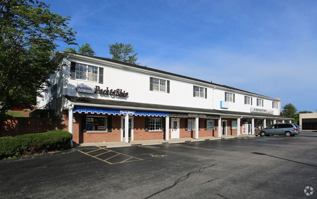

Property Detail
6561 Harrison Ave
550-0220-0251
HARRISON AV 1.2637 ACS R2-T2-S29
Regionalshoppingcenterormallwithanchorstore
Hamilton
EE
Ohio
B and X Area of moderate flood hazard, usually the area between the limits of the 100-year and 500-year floods.
1.26 AC
2025
Forest Park/West
2025
Cincinnati/Dayton
020603
Cincinnati, OH-KY-IN
18,600 SF
NEARBY LISTINGS FOR SALE OR LEASE
DEMOGRAPHICS near 6561 Harrison Ave
1 mile
3 mile
5 mile
2025 Total Population
6,529
38,330
126,490
2030 Population
6,520
38,296
126,455
Pop Growth 2025-2030
(0.14%)
(0.09%)
(0.03%)
Average Age
42
43
41
2025 Total Households
2,934
15,387
51,711
HH Growth 2025-2030
(0.07%)
(0.09%)
(0.06%)
Median Household Inc
$71,972
$91,696
$73,796
Avg Household Size
2.20
2.40
2.40
2025 Avg HH Vehicles
2.00
2.00
2.00
Median Home Value
$250,990
$273,699
$235,344
Median Year Built
1985
1981
1968
Nearby Places
Map Layers
Map Styles
 Street
 Aerial
Layers
 Traffic
 Biking
Places
Listings with unknown addresses are not visible on the map
- Restaurants
- Banks
- Shops
- Fitness
- Groceries
PUBLIC TRANSPORTATION
AIRPORT
Cincinnati/Northern Kentucky International
Drive
Walk
Distance
Cincinnati/Northern Kentucky International
37 min
23.9 mi
SALE & LEASE HISTORY
LISTING DATE
SALE/LEASE

Sep 25, 2016
For Lease
Nearby Properties
Address
Land Use
TOTAL SIZE
Lot Size
Zoning
Address
Land Use
TOTAL SIZE
Lot Size
Zoning
5.38 AC
OO
Address
Land Use
TOTAL SIZE
Lot Size
Zoning
12.23 AC
Address
Land Use
TOTAL SIZE
Lot Size
Zoning
474 SF
9.59 AC
A
Address
Land Use
TOTAL SIZE
Lot Size
Zoning
1,671 SF
21.48 AC
CCUP
Address
Land Use
TOTAL SIZE
Lot Size
Zoning
14.43 AC
Address
Land Use
TOTAL SIZE
Lot Size
Zoning
Address
Land Use
TOTAL SIZE
Lot Size
Zoning
4.68 AC
E
Address
Land Use
TOTAL SIZE
Lot Size
Zoning
29,084 SF
30.10 AC
DD
Address
Land Use
TOTAL SIZE
Lot Size
Zoning
20.34 AC
Address
Land Use
TOTAL SIZE
Lot Size
Zoning
360 SF
7.79 AC
F
Address
Land Use
TOTAL SIZE
Lot Size
Zoning
18.30 AC
EE
Address
Land Use
TOTAL SIZE
Lot Size
Zoning
4.28 AC
OO
Address
Land Use
TOTAL SIZE
Lot Size
Zoning
60,751 SF
9.57 AC
C
Address
Land Use
TOTAL SIZE
Lot Size
Zoning
8,580 SF
19.31 AC
DD
Address
Land Use
TOTAL SIZE
Lot Size
Zoning
Address
Land Use
TOTAL SIZE
Lot Size
Zoning
3.04 AC
OO
Address
Land Use
TOTAL SIZE
Lot Size
Zoning
35,496 SF
13.86 AC
A
Address
Land Use
TOTAL SIZE
Lot Size
Zoning
8.69 AC
EE
Address
Land Use
TOTAL SIZE
Lot Size
Zoning
31.99 AC
B
Address
Land Use
TOTAL SIZE
Lot Size
Zoning
58,082 SF
16.25 AC
B
Address
Land Use
TOTAL SIZE
Lot Size
Zoning
2.76 AC
EE
Address
Land Use
TOTAL SIZE
Lot Size
Zoning
Address
Land Use
TOTAL SIZE
Lot Size
Zoning
37,169 SF
12.82 AC
A
Address
Land Use
TOTAL SIZE
Lot Size
Zoning
2.16 AC
C
Address
Land Use
TOTAL SIZE
Lot Size
Zoning
Address
Land Use
TOTAL SIZE
Lot Size
Zoning
10,692 SF
8.93 AC
D
Address
Land Use
TOTAL SIZE
Lot Size
Zoning
14.99 AC
Address
Land Use
TOTAL SIZE
Lot Size
Zoning
Address
Land Use
TOTAL SIZE
Lot Size
Zoning
2,700 SF
5.30 AC
A
Address
Land Use
TOTAL SIZE
Lot Size
Zoning
The World's #1 Commercial Real Estate Marketplace
Connect with us
© 2026 CoStar Group
The information above has been obtained from sources believed reliable. While we do not doubt its accuracy we have not verified it and make no guarantee, warranty or representation about it. It is your responsibility to independently confirm its accuracy and completeness. Any projections, opinions, assumptions, or estimates used are for example only and do not represent the current or future performance of the property. The value of this transaction to you depends on tax and other factors which should be evaluated by your tax, financial, and legal advisors. You and your advisors should conduct a careful, independent investigation of the property to determine to your satisfaction the suitability of the property for your needs.