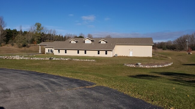
Property Record
6563 E Harrys Rd, Traverse City, MI 49684

Save to a Folder
{{folder.Name}}
{{folder.ListingIds.length}} Properties
{{folder.ListingIds.length}} Property
Create a New Folder
Property Detail
6563 E Harrys Rd
010-035-003-21
L416 P726/96 L592 P582/01 L672 P236/02 L790 P732/04 PRT SW 1/4 OF NE 1/4 SEC 35 COM E 1/4 COR SD SEC
Commercialnec
Leelanau
B and X Area of moderate flood hazard, usually the area between the limits of the 100-year and 500-year floods.
Michigan
0
9.86 AC
2026
Michigan Northwest Area
970501
Other Market Areas
14,708 SF
Traverse City, MI
NEARBY LISTINGS FOR SALE OR LEASE
-
-
View all Traverse City listings for sale on LoopNet.com
DEMOGRAPHICS near 6563 E Harrys Rd
1 mile
3 mile
5 mile
2025 Total Population
151
5,069
21,093
2030 Population
147
5,015
20,950
Pop Growth 2025-2030
(2.65%)
(1.07%)
(0.68%)
Average Age
45
43
45
2025 Total Households
60
2,068
8,932
HH Growth 2025-2030
(1.67%)
(1.06%)
(0.68%)
Median Household Inc
$97,916
$97,870
$98,467
Avg Household Size
2.50
2.40
2.30
2025 Avg HH Vehicles
2.00
2.00
2.00
Median Home Value
$374,999
$395,037
$411,333
Median Year Built
1979
1989
1985
Nearby Places
Map Layers
Map Styles
 Street
 Aerial
Layers
 Traffic
 Biking
Places
Listings with unknown addresses are not visible on the map
- Restaurants
- Banks
- Shops
- Fitness
- Groceries
PUBLIC TRANSPORTATION
AIRPORT
Cherry Capital
Drive
Walk
Distance
Cherry Capital
19 min
9.4 mi
SALE & LEASE HISTORY
LISTING DATE
SALE/LEASE

May 18, 2022
For Sale
Feb 25, 2021
For Sale
Nearby Properties
Address
Land Use
TOTAL SIZE
Lot Size
Zoning
Address
Land Use
TOTAL SIZE
Lot Size
Zoning
38,481 SF
42.96 AC
Address
Land Use
TOTAL SIZE
Lot Size
Zoning
6,789 SF
123.24 AC
Address
Land Use
TOTAL SIZE
Lot Size
Zoning
36,500 SF
10.49 AC
Address
Land Use
TOTAL SIZE
Lot Size
Zoning
576 SF
14.35 AC
Address
Land Use
TOTAL SIZE
Lot Size
Zoning
1,260 SF
23.77 AC
Address
Land Use
TOTAL SIZE
Lot Size
Zoning
160 SF
37.12 AC
Address
Land Use
TOTAL SIZE
Lot Size
Zoning
8,113 SF
1.27 AC
Address
Land Use
TOTAL SIZE
Lot Size
Zoning
0.77 AC
Address
Land Use
TOTAL SIZE
Lot Size
Zoning
8,160 SF
3.49 AC
Address
Land Use
TOTAL SIZE
Lot Size
Zoning
5,589 SF
8.08 AC
Address
Land Use
TOTAL SIZE
Lot Size
Zoning
46,756 SF
Address
Land Use
TOTAL SIZE
Lot Size
Zoning
Address
Land Use
TOTAL SIZE
Lot Size
Zoning
12,867 SF
11 AC
Address
Land Use
TOTAL SIZE
Lot Size
Zoning
9,800 SF
2.38 AC
Address
Land Use
TOTAL SIZE
Lot Size
Zoning
38,400 SF
9.24 AC
Address
Land Use
TOTAL SIZE
Lot Size
Zoning
480 SF
18.30 AC
Address
Land Use
TOTAL SIZE
Lot Size
Zoning
4,200 SF
4.01 AC
Address
Land Use
TOTAL SIZE
Lot Size
Zoning
68.98 AC
Address
Land Use
TOTAL SIZE
Lot Size
Zoning
11,200 SF
2.36 AC
Address
Land Use
TOTAL SIZE
Lot Size
Zoning
1,600 SF
1.03 AC
Address
Land Use
TOTAL SIZE
Lot Size
Zoning
6,547 SF
2.01 AC
Address
Land Use
TOTAL SIZE
Lot Size
Zoning
10,580 SF
40.50 AC
Address
Land Use
TOTAL SIZE
Lot Size
Zoning
5,100 SF
5.68 AC
Address
Land Use
TOTAL SIZE
Lot Size
Zoning
200.80 AC
Address
Land Use
TOTAL SIZE
Lot Size
Zoning
9,660 SF
0.99 AC
Address
Land Use
TOTAL SIZE
Lot Size
Zoning
576 SF
46.80 AC
Address
Land Use
TOTAL SIZE
Lot Size
Zoning
1,924 SF
38 AC
Address
Land Use
TOTAL SIZE
Lot Size
Zoning
3,876 SF
4.08 AC
Address
Land Use
TOTAL SIZE
Lot Size
Zoning
15,000 SF
3.80 AC
The World's #1 Commercial Real Estate Marketplace
Connect with us
© 2026 CoStar Group
The information above has been obtained from sources believed reliable. While we do not doubt its accuracy we have not verified it and make no guarantee, warranty or representation about it. It is your responsibility to independently confirm its accuracy and completeness. Any projections, opinions, assumptions, or estimates used are for example only and do not represent the current or future performance of the property. The value of this transaction to you depends on tax and other factors which should be evaluated by your tax, financial, and legal advisors. You and your advisors should conduct a careful, independent investigation of the property to determine to your satisfaction the suitability of the property for your needs.