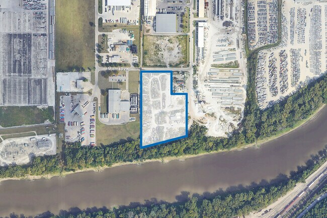
Property Record
6563 Miami Ave, Kansas City, KS 66111

Current Lease Availabilities
NEARBY LISTINGS FOR SALE OR LEASE
Property Detail
6563 Miami Ave
Kansas City, MO-KS
Muncie Industrial Park
233126
MUNCIE INDUSTRIAL PARK, S15, T11, R24, ACRES 7.47, B2 L10 LS: BEG 322.18FT E OF NW COR; E 142FT ALG N LN, SELY CUR RT-41.42FT ALG NELY LN, S 229.08FT ALG E LN, W 162FT, N 249.08FT TO POB
Parkinglot
Wyandotte
AE
Kansas
20209C0153D
10
2025
7.47 AC
2025
Kansas City KS
044002
Kansas City
325,466 SF
DEMOGRAPHICS near 6563 Miami Ave
1 Mile
3 Mile
5 Mile
2024 Total Population
1,379
27,188
124,932
2029 Population
1,358
26,523
123,555
Pop Growth 2024-2029
(1.52%)
(2.45%)
(1.10%)
Average Age
39
38
38
2024 Total Households
563
10,181
46,899
HH Growth 2024-2029
(1.60%)
(2.44%)
(0.87%)
Median Household Inc
$48,420
$58,957
$59,691
Avg Household Size
2.40
2.60
2.60
2024 Avg HH Vehicles
2.00
2.00
2.00
Median Home Value
$75,211
$161,319
$164,634
Median Year Built
1982
1967
1964
Nearby Places
Map Layers
Map Styles
 Street
 Aerial
- Restaurants
- Banks
- Shops
- Fitness
- Groceries
PUBLIC TRANSPORTATION
AIRPORT
Kansas City International
DRIVE
WALK
Distance
Kansas City International
33 min
23.4 mi
Freight Ports
Tulsa Port Of Catoosa
DRIVE
WALK
Distance
Tulsa Port Of Catoosa
270 min
238.4 mi
Nearby Properties
Address
Land Use
TOTAL SIZE
Lot Size
Zoning
Address
Land Use
TOTAL SIZE
Lot Size
Zoning
872,064 SF
119.39 AC
Address
Land Use
TOTAL SIZE
Lot Size
Zoning
347,991 SF
51.92 AC
1KMC
Address
Land Use
TOTAL SIZE
Lot Size
Zoning
542,696 SF
28.12 AC
Address
Land Use
TOTAL SIZE
Lot Size
Zoning
249,363 SF
58.59 AC
Address
Land Use
TOTAL SIZE
Lot Size
Zoning
346,224 SF
28.44 AC
Address
Land Use
TOTAL SIZE
Lot Size
Zoning
407,936 SF
37.46 AC
1
Address
Land Use
TOTAL SIZE
Lot Size
Zoning
396,532 SF
31.98 AC
Address
Land Use
TOTAL SIZE
Lot Size
Zoning
241,816 SF
20.03 AC
Address
Land Use
TOTAL SIZE
Lot Size
Zoning
100,090 SF
48.47 AC
KR1
Address
Land Use
TOTAL SIZE
Lot Size
Zoning
383,232 SF
15.93 AC
LU1
Address
Land Use
TOTAL SIZE
Lot Size
Zoning
158,011 SF
26.66 AC
Address
Land Use
TOTAL SIZE
Lot Size
Zoning
62,452 SF
14.89 AC
KR1
Address
Land Use
TOTAL SIZE
Lot Size
Zoning
132,724 SF
20.84 AC
KC1
Address
Land Use
TOTAL SIZE
Lot Size
Zoning
56,700 SF
18.97 AC
KR1
Address
Land Use
TOTAL SIZE
Lot Size
Zoning
62,068 SF
17.75 AC
KR1
Address
Land Use
TOTAL SIZE
Lot Size
Zoning
19,392 SF
2.77 AC
KCP1
Address
Land Use
TOTAL SIZE
Lot Size
Zoning
1,032,141 SF
45.80 AC
LU1
Address
Land Use
TOTAL SIZE
Lot Size
Zoning
164,462 SF
23.15 AC
Address
Land Use
TOTAL SIZE
Lot Size
Zoning
43,922 SF
5.81 AC
Address
Land Use
TOTAL SIZE
Lot Size
Zoning
512,620 SF
23.85 AC
KM3
Address
Land Use
TOTAL SIZE
Lot Size
Zoning
13,925 SF
107.85 AC
KR1
Address
Land Use
TOTAL SIZE
Lot Size
Zoning
14,120 SF
2.95 AC
Address
Land Use
TOTAL SIZE
Lot Size
Zoning
50,006 SF
18.98 AC
KR1
Address
Land Use
TOTAL SIZE
Lot Size
Zoning
27,022 SF
11.66 AC
K99
Address
Land Use
TOTAL SIZE
Lot Size
Zoning
167,713 SF
78.95 AC
KR1
Address
Land Use
TOTAL SIZE
Lot Size
Zoning
39,221 SF
10.44 AC
Address
Land Use
TOTAL SIZE
Lot Size
Zoning
43,445 SF
8.17 AC
KR1
Address
Land Use
TOTAL SIZE
Lot Size
Zoning
30,520 SF
7.03 AC
KRP5
Address
Land Use
TOTAL SIZE
Lot Size
Zoning
120,863 SF
8.36 AC
KCP1
Address
Land Use
TOTAL SIZE
Lot Size
Zoning
13,673 SF
4.81 AC
The World's #1 Commercial Real Estate Marketplace
Connect with us
© 2026 CoStar Group
The information above has been obtained from sources believed reliable. While we do not doubt its accuracy we have not verified it and make no guarantee, warranty or representation about it. It is your responsibility to independently confirm its accuracy and completeness. Any projections, opinions, assumptions, or estimates used are for example only and do not represent the current or future performance of the property. The value of this transaction to you depends on tax and other factors which should be evaluated by your tax, financial, and legal advisors. You and your advisors should conduct a careful, independent investigation of the property to determine to your satisfaction the suitability of the property for your needs.