Property Record
6564 N Smoke Tree Ln, Paradise Valley, AZ 85253
NEARBY LISTINGS FOR SALE OR LEASE
-
-
View all Paradise Valley listings for sale on LoopNet.com
Property Detail
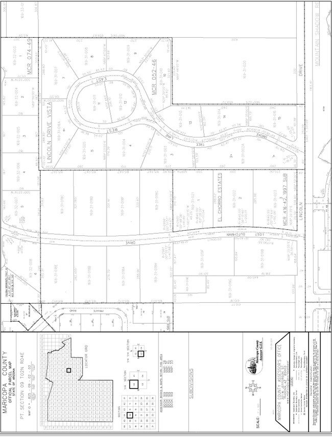
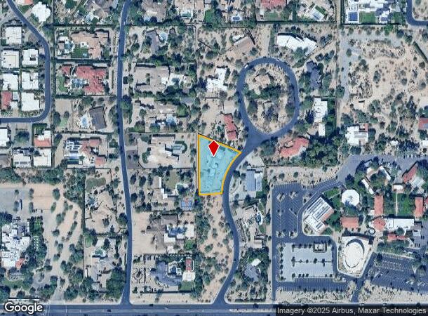
6564 N Smoke Tree Ln
Phoenix-Mesa-Scottsdale, AZ
Lincoln Drive Vista
169-31-003
LINCOLN DRIVE VISTA
Residentialacreage
Maricopa
X
Arizona
04013C1765L
3
2025
0.92 AC
2025
Paradise Valley
105004
Phoenix
2,056 SF
DEMOGRAPHICS near 6564 N Smoke Tree Ln
1 Mile
3 Mile
5 Mile
2024 Total Population
2,235
51,974
230,846
2029 Population
2,444
57,605
253,557
Pop Growth 2024-2029
+ 9.35%
+ 10.83%
+ 9.84%
Average Age
51
47
43
2024 Total Households
924
24,910
110,133
HH Growth 2024-2029
+ 9.31%
+ 11.20%
+ 10.12%
Median Household Inc
$209,691
$123,068
$91,671
Avg Household Size
2.40
2.10
2.00
2024 Avg HH Vehicles
2.00
2.00
2.00
Median Home Value
$1,133,418
$950,031
$654,555
Median Year Built
1984
1984
1978
Nearby Places
Map Layers
Map Styles
 Street
 Aerial
- Restaurants
- Banks
- Shops
- Fitness
- Groceries
PUBLIC TRANSPORTATION
AIRPORT
Phoenix Sky Harbor International
DRIVE
WALK
Distance
Phoenix Sky Harbor International
20 min
10.1 mi
Phoenix-Mesa Gateway
DRIVE
WALK
Distance
Phoenix-Mesa Gateway
47 min
32.6 mi
Freight Ports
Port of San Diego
DRIVE
WALK
Distance
Port of San Diego
413 min
366.1 mi
Nearby Properties
Address
Land Use
TOTAL SIZE
Lot Size
Zoning
Address
Land Use
TOTAL SIZE
Lot Size
Zoning
2,636,740 SF
21.88 AC
C-DT
Address
Land Use
TOTAL SIZE
Lot Size
Zoning
33,483 SF
7.82 AC
PF
Address
Land Use
TOTAL SIZE
Lot Size
Zoning
1,457,213 SF
41.78 AC
PUD
Address
Land Use
TOTAL SIZE
Lot Size
Zoning
981,325 SF
8.31 AC
Address
Land Use
TOTAL SIZE
Lot Size
Zoning
440,573 SF
19.10 AC
SUPR
Address
Land Use
TOTAL SIZE
Lot Size
Zoning
1,229,384 SF
4.81 AC
Address
Land Use
TOTAL SIZE
Lot Size
Zoning
517,502 SF
21.26 AC
SUPR
Address
Land Use
TOTAL SIZE
Lot Size
Zoning
457,979 SF
9.26 AC
CO
Address
Land Use
TOTAL SIZE
Lot Size
Zoning
268,262 SF
1.15 AC
C-DT
Address
Land Use
TOTAL SIZE
Lot Size
Zoning
22,630 SF
1.06 AC
SUPP
Address
Land Use
TOTAL SIZE
Lot Size
Zoning
282,287 SF
38.68 AC
R-10
Address
Land Use
TOTAL SIZE
Lot Size
Zoning
Address
Land Use
TOTAL SIZE
Lot Size
Zoning
590,903 SF
9.41 AC
C-DT
Address
Land Use
TOTAL SIZE
Lot Size
Zoning
1,137 SF
76.71 AC
RE35
Address
Land Use
TOTAL SIZE
Lot Size
Zoning
355,399 SF
7.13 AC
C-C
Address
Land Use
TOTAL SIZE
Lot Size
Zoning
508,796 SF
4.71 AC
PAD
Address
Land Use
TOTAL SIZE
Lot Size
Zoning
121,740 SF
22.13 AC
SUPR
Address
Land Use
TOTAL SIZE
Lot Size
Zoning
158,895 SF
6.83 AC
R-43
Address
Land Use
TOTAL SIZE
Lot Size
Zoning
138,984 SF
14.30 AC
C-C
Address
Land Use
TOTAL SIZE
Lot Size
Zoning
341,324 SF
1.93 AC
Address
Land Use
TOTAL SIZE
Lot Size
Zoning
194,044 SF
4.93 AC
C-2
Address
Land Use
TOTAL SIZE
Lot Size
Zoning
145,146 SF
8.21 AC
M-H
Address
Land Use
TOTAL SIZE
Lot Size
Zoning
181,494 SF
1.76 AC
PUD
Address
Land Use
TOTAL SIZE
Lot Size
Zoning
358,139 SF
5.31 AC
PUD
Address
Land Use
TOTAL SIZE
Lot Size
Zoning
457,244 SF
4.63 AC
C-T
Address
Land Use
TOTAL SIZE
Lot Size
Zoning
132,764 SF
3.97 AC
DDRU2
Address
Land Use
TOTAL SIZE
Lot Size
Zoning
214,351 SF
2.96 AC
PUD
Address
Land Use
TOTAL SIZE
Lot Size
Zoning
144,107 SF
8.57 AC
R-35
Address
Land Use
TOTAL SIZE
Lot Size
Zoning
359,568 SF
19 AC
RT
Address
Land Use
TOTAL SIZE
Lot Size
Zoning
209,344 SF
19.23 AC
PF
The World's #1 Commercial Real Estate Marketplace
Connect with us
© 2025 CoStar Group
The information above has been obtained from sources believed reliable. While we do not doubt its accuracy we have not verified it and make no guarantee, warranty or representation about it. It is your responsibility to independently confirm its accuracy and completeness. Any projections, opinions, assumptions, or estimates used are for example only and do not represent the current or future performance of the property. The value of this transaction to you depends on tax and other factors which should be evaluated by your tax, financial, and legal advisors. You and your advisors should conduct a careful, independent investigation of the property to determine to your satisfaction the suitability of the property for your needs.