Property Record
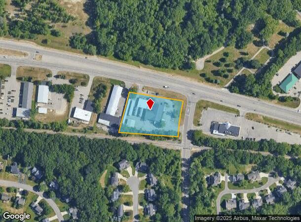
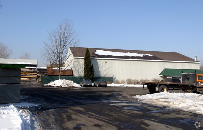
6566 Fulton St E, Ada, MI 49301

NEARBY LISTINGS FOR SALE OR LEASE
-
-
View all Ada listings for sale on LoopNet.com
Property Detail
6566 Fulton St E
41-15-28-324-009
Grand Rapids
Commercialnec
PART SW 1/4 COM AT INT OF SLY LINE OF RELOCATED HWY M21 & WLY LINE OF KULROSS AVE /120 FT WIDE/ TH SLY 207.72 FT ALONG WLY
X
Kent
26081C0434D
Michigan
2024
1.67 AC
2025
Ada/Lowell
011902
West Michigan
12,160 SF
Grand Rapids-Wyoming-Kentwood, MI
DEMOGRAPHICS near 6566 Fulton St E
1 Mile
3 Mile
5 Mile
2024 Total Population
2,468
21,271
62,211
2029 Population
2,499
21,540
62,812
Pop Growth 2024-2029
+ 1.26%
+ 1.26%
+ 0.97%
Average Age
40
40
40
2024 Total Households
835
7,302
22,543
HH Growth 2024-2029
+ 1.20%
+ 1.26%
+ 0.98%
Median Household Inc
$112,040
$133,932
$105,096
Avg Household Size
3.00
2.90
2.60
2024 Avg HH Vehicles
2.00
2.00
2.00
Median Home Value
$315,278
$405,307
$392,153
Median Year Built
1979
1991
1985
Nearby Places
Map Layers
Map Styles
 Street
 Aerial
- Restaurants
- Banks
- Shops
- Fitness
- Groceries
PUBLIC TRANSPORTATION
AIRPORT
Gerald R Ford International
DRIVE
WALK
Distance
Gerald R Ford International
22 min
11.4 mi
Freight Ports
Port Milwaukee
DRIVE
WALK
Distance
Port Milwaukee
316 min
272.0 mi
SALE & LEASE HISTORY
LISTING DATE
SALE/LEASE

Jan 19, 2021
For Sale
Nearby Properties
Address
Land Use
TOTAL SIZE
Lot Size
Zoning
Address
Land Use
TOTAL SIZE
Lot Size
Zoning
277.36 AC
I
Address
Land Use
TOTAL SIZE
Lot Size
Zoning
709,488 SF
106.95 AC
LI
Address
Land Use
TOTAL SIZE
Lot Size
Zoning
Address
Land Use
TOTAL SIZE
Lot Size
Zoning
226,877 SF
22.40 AC
R2
Address
Land Use
TOTAL SIZE
Lot Size
Zoning
183,583 SF
9.12 AC
R-1
Address
Land Use
TOTAL SIZE
Lot Size
Zoning
8.97 AC
Address
Land Use
TOTAL SIZE
Lot Size
Zoning
Address
Land Use
TOTAL SIZE
Lot Size
Zoning
Address
Land Use
TOTAL SIZE
Lot Size
Zoning
33,540 SF
5.67 AC
PO
Address
Land Use
TOTAL SIZE
Lot Size
Zoning
79,374 SF
12.20 AC
C-2
Address
Land Use
TOTAL SIZE
Lot Size
Zoning
14,700 SF
1.44 AC
Address
Land Use
TOTAL SIZE
Lot Size
Zoning
81,494 SF
21.36 AC
R-1
Address
Land Use
TOTAL SIZE
Lot Size
Zoning
0.65 AC
Address
Land Use
TOTAL SIZE
Lot Size
Zoning
67,789 SF
9.51 AC
O-PUD
Address
Land Use
TOTAL SIZE
Lot Size
Zoning
66,036 SF
4.38 AC
O-PUD
Address
Land Use
TOTAL SIZE
Lot Size
Zoning
Address
Land Use
TOTAL SIZE
Lot Size
Zoning
64,790 SF
290,921.90 AC
PUD
Address
Land Use
TOTAL SIZE
Lot Size
Zoning
29,224 SF
5.48 AC
I
Address
Land Use
TOTAL SIZE
Lot Size
Zoning
0.20 AC
Address
Land Use
TOTAL SIZE
Lot Size
Zoning
44,215 SF
12.51 AC
PUD
Address
Land Use
TOTAL SIZE
Lot Size
Zoning
4,600 SF
0.64 AC
Address
Land Use
TOTAL SIZE
Lot Size
Zoning
39,312 SF
7.01 AC
R2
Address
Land Use
TOTAL SIZE
Lot Size
Zoning
0.92 AC
C1
Address
Land Use
TOTAL SIZE
Lot Size
Zoning
18,096 SF
2.53 AC
PO
Address
Land Use
TOTAL SIZE
Lot Size
Zoning
37,134 SF
4.01 AC
C-2
Address
Land Use
TOTAL SIZE
Lot Size
Zoning
87,210 SF
4 AC
I
Address
Land Use
TOTAL SIZE
Lot Size
Zoning
55,541 SF
3.99 AC
C
Address
Land Use
TOTAL SIZE
Lot Size
Zoning
34,276 SF
6.40 AC
PO
Address
Land Use
TOTAL SIZE
Lot Size
Zoning
16,462 SF
1.73 AC
O-PUD
Address
Land Use
TOTAL SIZE
Lot Size
Zoning
9,414 SF
1.64 AC
The World's #1 Commercial Real Estate Marketplace
Connect with us
© 2026 CoStar Group
The information above has been obtained from sources believed reliable. While we do not doubt its accuracy we have not verified it and make no guarantee, warranty or representation about it. It is your responsibility to independently confirm its accuracy and completeness. Any projections, opinions, assumptions, or estimates used are for example only and do not represent the current or future performance of the property. The value of this transaction to you depends on tax and other factors which should be evaluated by your tax, financial, and legal advisors. You and your advisors should conduct a careful, independent investigation of the property to determine to your satisfaction the suitability of the property for your needs.