Property Record
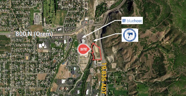
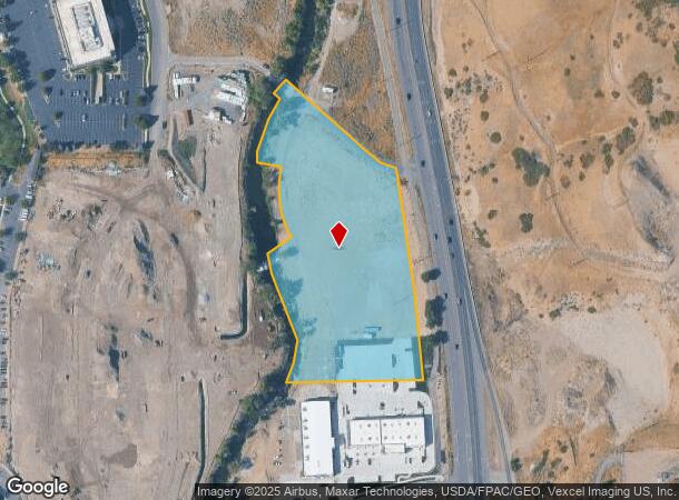
657 N University Ave, Provo, UT 84601
NEARBY LISTINGS FOR SALE OR LEASE
Property Detail
657 N University Ave
Other Market Areas
Canyon River Sub
Provo-Orem, UT
LOT 5, PLAT B, CANYON RIVER SUB AREA 5.487 AC.
65-345-0005
Utah
Vacantlandnec
Utah
2024
5
2025
5.49 AC
001900
DEMOGRAPHICS near 657 N University Ave
1 Mile
3 Mile
5 Mile
2024 Total Population
44,030
131,268
187,674
2029 Population
48,857
144,433
206,397
Pop Growth 2024-2029
+ 10.96%
+ 10.03%
+ 9.98%
Average Age
24
28
29
2024 Total Households
12,228
37,483
53,828
HH Growth 2024-2029
+ 11.65%
+ 10.31%
+ 10.19%
Median Household Inc
$29,410
$43,305
$50,303
Avg Household Size
3.10
3.20
3.20
2024 Avg HH Vehicles
2.00
2.00
2.00
Median Home Value
$225,046
$263,762
$264,792
Median Year Built
1976
1979
1982
Nearby Places
Map Layers
Map Styles
 Street
 Aerial
- Restaurants
- Banks
- Shops
- Fitness
- Groceries
PUBLIC TRANSPORTATION
COMMUTER RAIL
Vineyard Station (FrontRunner - Utah Transit Authority (UTA))
DRIVE
WALK
Distance
Vineyard Station (FrontRunner - Utah Transit Authority (UTA))
10 min
5.1 mi
Orem Central Station (FrontRunner - Utah Transit Authority (UTA))
DRIVE
WALK
Distance
Orem Central Station (FrontRunner - Utah Transit Authority (UTA))
13 min
7.0 mi
AIRPORT
Provo Municipal
DRIVE
WALK
Distance
Provo Municipal
17 min
10.7 mi
Freight Ports
Port of Stockton
DRIVE
WALK
Distance
Port of Stockton
755 min
735.6 mi
Nearby Properties
Address
Land Use
TOTAL SIZE
Lot Size
Zoning
Address
Land Use
TOTAL SIZE
Lot Size
Zoning
623,237 SF
14.06 AC
Address
Land Use
TOTAL SIZE
Lot Size
Zoning
530,326 SF
8.14 AC
Address
Land Use
TOTAL SIZE
Lot Size
Zoning
627,022 SF
9.16 AC
Address
Land Use
TOTAL SIZE
Lot Size
Zoning
310,818 SF
1.17 AC
Address
Land Use
TOTAL SIZE
Lot Size
Zoning
219,346 SF
2.20 AC
Address
Land Use
TOTAL SIZE
Lot Size
Zoning
199,119 SF
17.18 AC
Address
Land Use
TOTAL SIZE
Lot Size
Zoning
122,784 SF
12.46 AC
Address
Land Use
TOTAL SIZE
Lot Size
Zoning
401,381 SF
3.50 AC
Address
Land Use
TOTAL SIZE
Lot Size
Zoning
154,685 SF
13.20 AC
Address
Land Use
TOTAL SIZE
Lot Size
Zoning
311,697 SF
6.49 AC
Address
Land Use
TOTAL SIZE
Lot Size
Zoning
139,462 SF
3.93 AC
Address
Land Use
TOTAL SIZE
Lot Size
Zoning
124,242 SF
9.33 AC
Address
Land Use
TOTAL SIZE
Lot Size
Zoning
179,347 SF
13.55 AC
Address
Land Use
TOTAL SIZE
Lot Size
Zoning
4,053 SF
18.21 AC
Address
Land Use
TOTAL SIZE
Lot Size
Zoning
170,536 SF
2.16 AC
Address
Land Use
TOTAL SIZE
Lot Size
Zoning
204,655 SF
8.10 AC
Address
Land Use
TOTAL SIZE
Lot Size
Zoning
211,929 SF
1.30 AC
Address
Land Use
TOTAL SIZE
Lot Size
Zoning
124,183 SF
4.28 AC
Address
Land Use
TOTAL SIZE
Lot Size
Zoning
83,568 SF
2 AC
Address
Land Use
TOTAL SIZE
Lot Size
Zoning
123,663 SF
5.31 AC
Address
Land Use
TOTAL SIZE
Lot Size
Zoning
157,768 SF
13.17 AC
Address
Land Use
TOTAL SIZE
Lot Size
Zoning
80,621 SF
1.76 AC
Address
Land Use
TOTAL SIZE
Lot Size
Zoning
182,166 SF
2.32 AC
Address
Land Use
TOTAL SIZE
Lot Size
Zoning
151,182 SF
6.41 AC
Address
Land Use
TOTAL SIZE
Lot Size
Zoning
122,527 SF
7.50 AC
Address
Land Use
TOTAL SIZE
Lot Size
Zoning
100,726 SF
2.88 AC
Address
Land Use
TOTAL SIZE
Lot Size
Zoning
109,816 SF
3.61 AC
Address
Land Use
TOTAL SIZE
Lot Size
Zoning
11.41 AC
Address
Land Use
TOTAL SIZE
Lot Size
Zoning
111,516 SF
3.46 AC
Address
Land Use
TOTAL SIZE
Lot Size
Zoning
75,813 SF
7.09 AC
The World's #1 Commercial Real Estate Marketplace
Connect with us
© 2025 CoStar Group
The information above has been obtained from sources believed reliable. While we do not doubt its accuracy we have not verified it and make no guarantee, warranty or representation about it. It is your responsibility to independently confirm its accuracy and completeness. Any projections, opinions, assumptions, or estimates used are for example only and do not represent the current or future performance of the property. The value of this transaction to you depends on tax and other factors which should be evaluated by your tax, financial, and legal advisors. You and your advisors should conduct a careful, independent investigation of the property to determine to your satisfaction the suitability of the property for your needs.