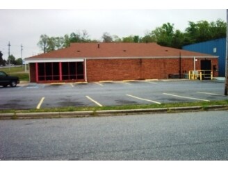
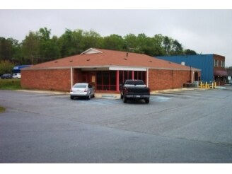
Property Record
657 Oak St, Forest City, NC 28043

Property Detail
657 Oak St
Restaurantbuilding
GPIN:1538089827290000; CRAZY JOES OAK STREET
C3
Rutherford
B and X Area of moderate flood hazard, usually the area between the limits of the 100-year and 500-year floods.
North Carolina
2025
0.52 AC
2025
Other Market Areas
960800
Forest City, NC
5,444 SF
1609326
NEARBY LISTINGS FOR SALE OR LEASE
DEMOGRAPHICS near 657 Oak St
1 mile
3 mile
5 mile
2025 Total Population
2,321
14,230
27,393
2030 Population
2,343
14,331
27,649
Pop Growth 2025-2030
+ 0.95%
+ 0.71%
+ 0.93%
Average Age
41
41
42
2025 Total Households
999
5,784
11,268
HH Growth 2025-2030
+ 1.00%
+ 0.61%
+ 0.85%
Median Household Inc
$32,610
$39,094
$39,817
Avg Household Size
2.20
2.30
2.30
2025 Avg HH Vehicles
1.00
2.00
2.00
Median Home Value
$105,369
$187,698
$186,145
Median Year Built
1968
1969
1972
Nearby Places
Map Layers
Map Styles
 Street
 Aerial
Layers
 Traffic
 Biking
Places
Listings with unknown addresses are not visible on the map
- Restaurants
- Banks
- Shops
- Fitness
- Groceries
PUBLIC TRANSPORTATION
AIRPORT
Greenville Spartanburg International
Drive
Walk
Distance
Greenville Spartanburg International
69 min
49.7 mi
Nearby Properties
Address
Land Use
TOTAL SIZE
Lot Size
Zoning
Address
Land Use
TOTAL SIZE
Lot Size
Zoning
204,184 SF
28.30 AC
C3
Address
Land Use
TOTAL SIZE
Lot Size
Zoning
124,707 SF
30.99 AC
C3
Address
Land Use
TOTAL SIZE
Lot Size
Zoning
87,123 SF
1.98 AC
Address
Land Use
TOTAL SIZE
Lot Size
Zoning
87,108 SF
26.73 AC
GC
Address
Land Use
TOTAL SIZE
Lot Size
Zoning
37,979 SF
9.36 AC
R8
Address
Land Use
TOTAL SIZE
Lot Size
Zoning
64,697 SF
18.07 AC
R8
Address
Land Use
TOTAL SIZE
Lot Size
Zoning
23,826 SF
13.78 AC
M1
Address
Land Use
TOTAL SIZE
Lot Size
Zoning
111,158 SF
11.15 AC
C3
Address
Land Use
TOTAL SIZE
Lot Size
Zoning
63,006 SF
14.29 AC
Address
Land Use
TOTAL SIZE
Lot Size
Zoning
328,907 SF
52.37 AC
Address
Land Use
TOTAL SIZE
Lot Size
Zoning
58,300 SF
3.13 AC
C3
Address
Land Use
TOTAL SIZE
Lot Size
Zoning
4,982 SF
27.13 AC
Address
Land Use
TOTAL SIZE
Lot Size
Zoning
343,372 SF
49.89 AC
M1ETJ
Address
Land Use
TOTAL SIZE
Lot Size
Zoning
14,832 SF
3.11 AC
C2
Address
Land Use
TOTAL SIZE
Lot Size
Zoning
87,740 SF
10.47 AC
C3
Address
Land Use
TOTAL SIZE
Lot Size
Zoning
8,880 SF
11.85 AC
C3
Address
Land Use
TOTAL SIZE
Lot Size
Zoning
12,480 SF
43 AC
Address
Land Use
TOTAL SIZE
Lot Size
Zoning
95,267 SF
8.40 AC
GC
Address
Land Use
TOTAL SIZE
Lot Size
Zoning
16,074 SF
101.60 AC
Address
Land Use
TOTAL SIZE
Lot Size
Zoning
12,580 SF
7.90 AC
R8
Address
Land Use
TOTAL SIZE
Lot Size
Zoning
483 SF
6.26 AC
C3
Address
Land Use
TOTAL SIZE
Lot Size
Zoning
36,693 SF
3.04 AC
C3
Address
Land Use
TOTAL SIZE
Lot Size
Zoning
4,700 SF
4.70 AC
C2
Address
Land Use
TOTAL SIZE
Lot Size
Zoning
23,990 SF
3 AC
Address
Land Use
TOTAL SIZE
Lot Size
Zoning
6,448 SF
3.30 AC
GC
Address
Land Use
TOTAL SIZE
Lot Size
Zoning
6,000 SF
15.30 AC
Address
Land Use
TOTAL SIZE
Lot Size
Zoning
1,444 SF
5.06 AC
C3
Address
Land Use
TOTAL SIZE
Lot Size
Zoning
150,739 SF
35.14 AC
Address
Land Use
TOTAL SIZE
Lot Size
Zoning
6,320 SF
10.50 AC
R6
Address
Land Use
TOTAL SIZE
Lot Size
Zoning
17,755 SF
7.05 AC
R8
The World's #1 Commercial Real Estate Marketplace
Connect with us
© 2026 CoStar Group
The information above has been obtained from sources believed reliable. While we do not doubt its accuracy we have not verified it and make no guarantee, warranty or representation about it. It is your responsibility to independently confirm its accuracy and completeness. Any projections, opinions, assumptions, or estimates used are for example only and do not represent the current or future performance of the property. The value of this transaction to you depends on tax and other factors which should be evaluated by your tax, financial, and legal advisors. You and your advisors should conduct a careful, independent investigation of the property to determine to your satisfaction the suitability of the property for your needs.