Property Record
6574 E Brainerd Rd, Chattanooga, TN 37421
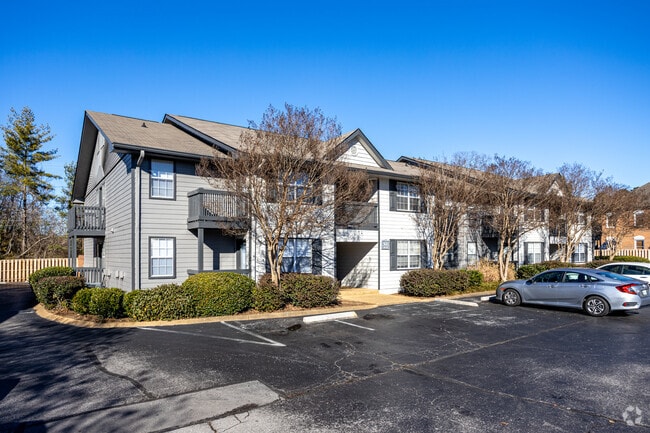

Property Detail
6574 E Brainerd Rd
158G-B-002
LTS 1 3 & 4 WANDA POTTER SUB 41-149 41-296 REV 42-106 HAMILTON POINT 361 UNITS
Multifamilydwelling
Hamilton
R1
Tennessee
B and X Area of moderate flood hazard, usually the area between the limits of the 100-year and 500-year floods.
1,3,4
2025
17.72 AC
2025
Marimont-Old Crab Tree
003400
Chattanooga
20,964 SF
Chattanooga, TN-GA
NEARBY LISTINGS FOR SALE OR LEASE
DEMOGRAPHICS near 6574 E Brainerd Rd
1 mile
3 mile
5 mile
2025 Total Population
5,538
48,872
141,167
2030 Population
5,814
51,259
147,502
Pop Growth 2025-2030
+ 4.98%
+ 4.88%
+ 4.49%
Average Age
39
41
41
2025 Total Households
2,593
21,218
58,494
HH Growth 2025-2030
+ 5.09%
+ 5.02%
+ 4.63%
Median Household Inc
$55,145
$60,974
$64,978
Avg Household Size
2.10
2.20
2.30
2025 Avg HH Vehicles
2.00
2.00
2.00
Median Home Value
$280,475
$265,570
$268,547
Median Year Built
1976
1977
1976
Nearby Places
Map Layers
Map Styles
 Street
 Aerial
Transit
 Traffic
 Biking
Places
Listings with unknown addresses are not visible on the map
- Restaurants
- Banks
- Shops
- Fitness
- Groceries
PUBLIC TRANSPORTATION
AIRPORT
Lovell Field
Drive
Walk
Distance
Lovell Field
10 min
2.8 mi
Freight Ports
Georgia Ports - Savannah
Drive
Walk
Distance
Georgia Ports - Savannah
404 min
360.4 mi
Nearby Properties
Address
Land Use
TOTAL SIZE
Lot Size
Zoning
Address
Land Use
TOTAL SIZE
Lot Size
Zoning
831.19 AC
M1
Address
Land Use
TOTAL SIZE
Lot Size
Zoning
440,611 SF
27.46 AC
C2
Address
Land Use
TOTAL SIZE
Lot Size
Zoning
292,309 SF
45.28 AC
M1
Address
Land Use
TOTAL SIZE
Lot Size
Zoning
117,007 SF
23.87 AC
R4
Address
Land Use
TOTAL SIZE
Lot Size
Zoning
4,418 SF
18.01 AC
R3
Address
Land Use
TOTAL SIZE
Lot Size
Zoning
43,488 SF
27.72 AC
R3
Address
Land Use
TOTAL SIZE
Lot Size
Zoning
25,436 SF
21.34 AC
R3
Address
Land Use
TOTAL SIZE
Lot Size
Zoning
43,576 SF
6.66 AC
C2
Address
Land Use
TOTAL SIZE
Lot Size
Zoning
25,462 SF
16.20 AC
R1
Address
Land Use
TOTAL SIZE
Lot Size
Zoning
97,000 SF
18.78 AC
Address
Land Use
TOTAL SIZE
Lot Size
Zoning
25,165 SF
21.90 AC
Address
Land Use
TOTAL SIZE
Lot Size
Zoning
99,202 SF
17.32 AC
Address
Land Use
TOTAL SIZE
Lot Size
Zoning
129,710 SF
4.55 AC
R1
Address
Land Use
TOTAL SIZE
Lot Size
Zoning
291,314 SF
29.69 AC
M1
Address
Land Use
TOTAL SIZE
Lot Size
Zoning
15,808 SF
19.50 AC
R2
Address
Land Use
TOTAL SIZE
Lot Size
Zoning
50,506 SF
5.14 AC
MD
Address
Land Use
TOTAL SIZE
Lot Size
Zoning
4,390 SF
36.30 AC
R3
Address
Land Use
TOTAL SIZE
Lot Size
Zoning
110,710 SF
6.69 AC
M1
Address
Land Use
TOTAL SIZE
Lot Size
Zoning
238,806 SF
24.84 AC
Address
Land Use
TOTAL SIZE
Lot Size
Zoning
8,032 SF
19.80 AC
Address
Land Use
TOTAL SIZE
Lot Size
Zoning
94,369 SF
26.27 AC
R2
Address
Land Use
TOTAL SIZE
Lot Size
Zoning
66,390 SF
4.37 AC
C2
Address
Land Use
TOTAL SIZE
Lot Size
Zoning
181,612 SF
14.10 AC
Address
Land Use
TOTAL SIZE
Lot Size
Zoning
790,207 SF
53.84 AC
C2
Address
Land Use
TOTAL SIZE
Lot Size
Zoning
176.54 AC
R1
Address
Land Use
TOTAL SIZE
Lot Size
Zoning
21,280 SF
7.67 AC
Address
Land Use
TOTAL SIZE
Lot Size
Zoning
117,663 SF
13.51 AC
C4
Address
Land Use
TOTAL SIZE
Lot Size
Zoning
71,293 SF
8.16 AC
C2
Address
Land Use
TOTAL SIZE
Lot Size
Zoning
43.48 AC
R4
The World's #1 Commercial Real Estate Marketplace
Connect with us
© 2026 CoStar Group
The information above has been obtained from sources believed reliable. While we do not doubt its accuracy we have not verified it and make no guarantee, warranty or representation about it. It is your responsibility to independently confirm its accuracy and completeness. Any projections, opinions, assumptions, or estimates used are for example only and do not represent the current or future performance of the property. The value of this transaction to you depends on tax and other factors which should be evaluated by your tax, financial, and legal advisors. You and your advisors should conduct a careful, independent investigation of the property to determine to your satisfaction the suitability of the property for your needs.