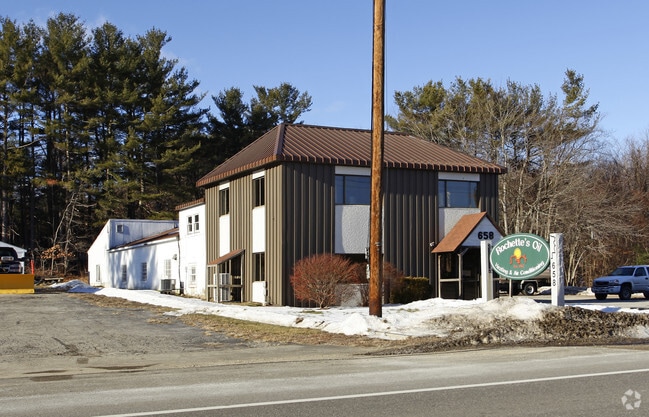
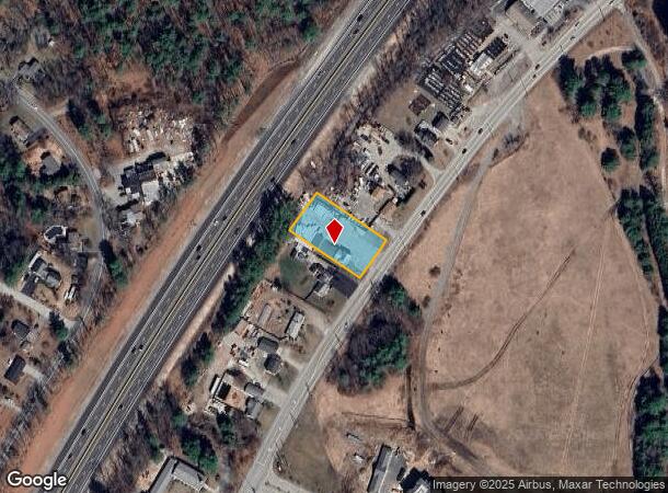
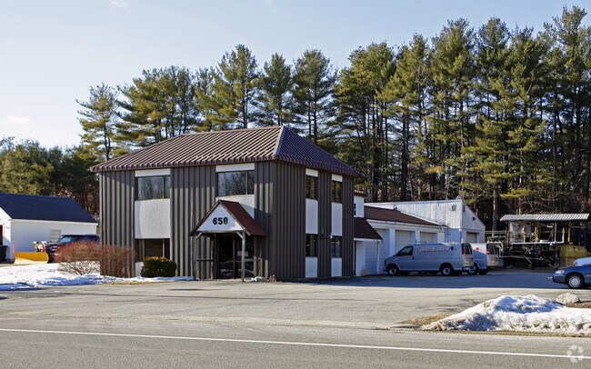
Property Record
658 Daniel Webster Hwy, Merrimack, NH 03054
NEARBY LISTINGS FOR SALE OR LEASE
Property Detail
658 Daniel Webster Hwy
MRMK-000602E-000013
Hillsborough
Commercialbuilding
New Hampshire
X
13
33011C0388D
0.50 AC
2024
Hillsborough
2024
Boston
014101
Manchester-Nashua, NH
6,207 SF
DEMOGRAPHICS near 658 Daniel Webster Hwy
1 Mile
3 Mile
5 Mile
2024 Total Population
4,550
24,052
63,835
2029 Population
4,695
24,613
65,706
Pop Growth 2024-2029
+ 3.19%
+ 2.33%
+ 2.93%
Average Age
42
42
42
2024 Total Households
1,922
9,102
23,877
HH Growth 2024-2029
+ 3.07%
+ 2.35%
+ 2.99%
Median Household Inc
$86,013
$109,934
$115,088
Avg Household Size
2.30
2.60
2.60
2024 Avg HH Vehicles
2.00
2.00
2.00
Median Home Value
$305,132
$365,399
$391,875
Median Year Built
1981
1984
1984
Nearby Places
Map Layers
Map Styles
 Street
 Aerial
- Restaurants
- Banks
- Shops
- Fitness
- Groceries
PUBLIC TRANSPORTATION
AIRPORT
Manchester Boston Regional
DRIVE
WALK
Distance
Manchester Boston Regional
10 min
4.3 mi
Freight Ports
Port of Boston
DRIVE
WALK
Distance
Port of Boston
80 min
59.1 mi
Nearby Properties
Address
Land Use
TOTAL SIZE
Lot Size
Zoning
Address
Land Use
TOTAL SIZE
Lot Size
Zoning
768,020 SF
74.47 AC
I-II
Address
Land Use
TOTAL SIZE
Lot Size
Zoning
202,546 SF
55 AC
RESIDE
Address
Land Use
TOTAL SIZE
Lot Size
Zoning
603,357 SF
45.12 AC
GB
Address
Land Use
TOTAL SIZE
Lot Size
Zoning
56,997 SF
31.28 AC
INDUST
Address
Land Use
TOTAL SIZE
Lot Size
Zoning
0.60 AC
PZ
Address
Land Use
TOTAL SIZE
Lot Size
Zoning
42,228 SF
15.58 AC
PZ
Address
Land Use
TOTAL SIZE
Lot Size
Zoning
50.47 AC
GB
Address
Land Use
TOTAL SIZE
Lot Size
Zoning
151,002 SF
6.95 AC
PZ
Address
Land Use
TOTAL SIZE
Lot Size
Zoning
142,318 SF
26.13 AC
GB
Address
Land Use
TOTAL SIZE
Lot Size
Zoning
227,589 SF
GB
Address
Land Use
TOTAL SIZE
Lot Size
Zoning
244,637 SF
27.28 AC
IND-II
Address
Land Use
TOTAL SIZE
Lot Size
Zoning
13,395 SF
8.16 AC
PZ
Address
Land Use
TOTAL SIZE
Lot Size
Zoning
116.34 AC
IND-II
Address
Land Use
TOTAL SIZE
Lot Size
Zoning
187,046 SF
17.40 AC
PZ
Address
Land Use
TOTAL SIZE
Lot Size
Zoning
24.20 AC
GB
Address
Land Use
TOTAL SIZE
Lot Size
Zoning
24,495 SF
13.05 AC
RESIDE
Address
Land Use
TOTAL SIZE
Lot Size
Zoning
5,894 SF
12.50 AC
RESIDE
Address
Land Use
TOTAL SIZE
Lot Size
Zoning
1.63 AC
RES
Address
Land Use
TOTAL SIZE
Lot Size
Zoning
69,045 SF
35 AC
RESIDE
Address
Land Use
TOTAL SIZE
Lot Size
Zoning
107,615 SF
13.34 AC
PZ
Address
Land Use
TOTAL SIZE
Lot Size
Zoning
19,260 SF
4.73 AC
PZ
Address
Land Use
TOTAL SIZE
Lot Size
Zoning
70,098 SF
7.69 AC
C2- GE
Address
Land Use
TOTAL SIZE
Lot Size
Zoning
92,235 SF
8.95 AC
PZ
Address
Land Use
TOTAL SIZE
Lot Size
Zoning
Address
Land Use
TOTAL SIZE
Lot Size
Zoning
74,276 SF
17.79 AC
PZ
Address
Land Use
TOTAL SIZE
Lot Size
Zoning
240,111 SF
21.18 AC
INDUST
Address
Land Use
TOTAL SIZE
Lot Size
Zoning
67,668 SF
4.76 AC
PZ
Address
Land Use
TOTAL SIZE
Lot Size
Zoning
70,180 SF
10.34 AC
IND-II
Address
Land Use
TOTAL SIZE
Lot Size
Zoning
125,088 SF
8.94 AC
PZ
Address
Land Use
TOTAL SIZE
Lot Size
Zoning
142,740 SF
3.16 AC
INDUST
The World's #1 Commercial Real Estate Marketplace
Connect with us
© 2025 CoStar Group
The information above has been obtained from sources believed reliable. While we do not doubt its accuracy we have not verified it and make no guarantee, warranty or representation about it. It is your responsibility to independently confirm its accuracy and completeness. Any projections, opinions, assumptions, or estimates used are for example only and do not represent the current or future performance of the property. The value of this transaction to you depends on tax and other factors which should be evaluated by your tax, financial, and legal advisors. You and your advisors should conduct a careful, independent investigation of the property to determine to your satisfaction the suitability of the property for your needs.