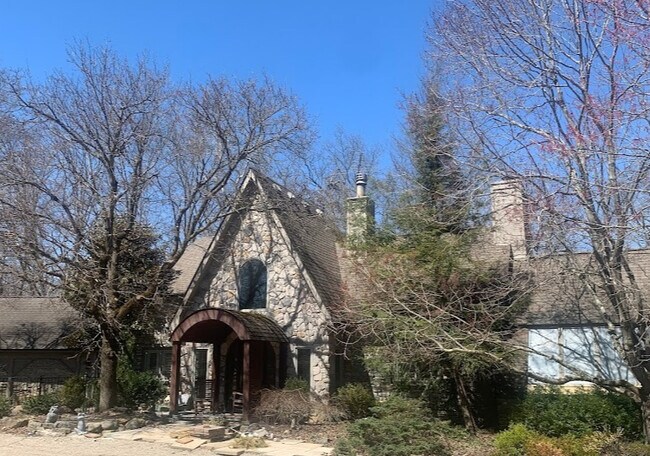
Property Record
6580 Harriott Rd, Powell, OH 43065


NEARBY LISTINGS FOR SALE OR LEASE
Property Detail
6580 Harriott Rd
600-310-03-069-000
R Coopers Surv 2546
Storebuilding
LANDS SURVEY 2546
X
Delaware
39159C0395E
Ohio
2024
5.01 AC
2024
Outlying Delaware County
011412
Columbus
5,027 SF
Columbus, OH
DEMOGRAPHICS near 6580 Harriott Rd
1 mile
3 mile
5 mile
2024 Total Population
3,143
41,644
105,983
2029 Population
3,555
46,976
115,993
Pop Growth 2024-2029
+ 13.11%
+ 12.80%
+ 9.44%
Average Age
42
40
39
2024 Total Households
1,084
13,992
37,331
HH Growth 2024-2029
+ 13.28%
+ 12.93%
+ 9.22%
Median Household Inc
$186,033
$180,478
$145,867
Avg Household Size
2.90
3.00
2.80
2024 Avg HH Vehicles
2.00
2.00
2.00
Median Home Value
$601,109
$495,738
$444,441
Median Year Built
1988
2002
1996
Nearby Places
Map Layers
Map Styles
 Street
 Aerial
Transit
 Traffic
 Biking
Places
Listings with unknown addresses are not visible on the map
- Restaurants
- Banks
- Shops
- Fitness
- Groceries
PUBLIC TRANSPORTATION
AIRPORT
John Glenn Columbus International
Drive
Walk
Distance
John Glenn Columbus International
36 min
25.0 mi
Rickenbacker International
Drive
Walk
Distance
Rickenbacker International
48 min
34.3 mi
Freight Ports
Port of Toledo
Drive
Walk
Distance
Port of Toledo
167 min
132.2 mi
SALE & LEASE HISTORY
LISTING DATE
SALE/LEASE

Feb 10, 2022
For Sale
Nearby Properties
Address
Land Use
TOTAL SIZE
Lot Size
Zoning
Address
Land Use
TOTAL SIZE
Lot Size
Zoning
90.16 AC
Address
Land Use
TOTAL SIZE
Lot Size
Zoning
247,368 SF
7.88 AC
Address
Land Use
TOTAL SIZE
Lot Size
Zoning
159,901 SF
19.97 AC
Address
Land Use
TOTAL SIZE
Lot Size
Zoning
59,144 SF
87.61 AC
Address
Land Use
TOTAL SIZE
Lot Size
Zoning
113,169 SF
33.30 AC
Address
Land Use
TOTAL SIZE
Lot Size
Zoning
103,368 SF
13.48 AC
Address
Land Use
TOTAL SIZE
Lot Size
Zoning
31,496 SF
3.25 AC
Address
Land Use
TOTAL SIZE
Lot Size
Zoning
3,200 SF
39.80 AC
Address
Land Use
TOTAL SIZE
Lot Size
Zoning
4,204 SF
118.93 AC
Address
Land Use
TOTAL SIZE
Lot Size
Zoning
9,493 SF
248.77 AC
Address
Land Use
TOTAL SIZE
Lot Size
Zoning
47,548 SF
9.28 AC
Address
Land Use
TOTAL SIZE
Lot Size
Zoning
64,520 SF
12 AC
Address
Land Use
TOTAL SIZE
Lot Size
Zoning
51,561 SF
7.79 AC
Address
Land Use
TOTAL SIZE
Lot Size
Zoning
12,336 SF
147.79 AC
Address
Land Use
TOTAL SIZE
Lot Size
Zoning
37,997 SF
160.59 AC
Address
Land Use
TOTAL SIZE
Lot Size
Zoning
32,891 SF
11.94 AC
Address
Land Use
TOTAL SIZE
Lot Size
Zoning
33,711 SF
5.08 AC
Address
Land Use
TOTAL SIZE
Lot Size
Zoning
22,080 SF
11.95 AC
Address
Land Use
TOTAL SIZE
Lot Size
Zoning
76,011 SF
8.89 AC
Address
Land Use
TOTAL SIZE
Lot Size
Zoning
2,712 SF
1.69 AC
Address
Land Use
TOTAL SIZE
Lot Size
Zoning
42,911 SF
9.43 AC
Address
Land Use
TOTAL SIZE
Lot Size
Zoning
21,262 SF
104.67 AC
Address
Land Use
TOTAL SIZE
Lot Size
Zoning
30,650 SF
11.43 AC
Address
Land Use
TOTAL SIZE
Lot Size
Zoning
7,394 SF
310.47 AC
Address
Land Use
TOTAL SIZE
Lot Size
Zoning
16,775 SF
1.33 AC
Address
Land Use
TOTAL SIZE
Lot Size
Zoning
25,458 SF
4.58 AC
Address
Land Use
TOTAL SIZE
Lot Size
Zoning
27,874 SF
11.82 AC
Address
Land Use
TOTAL SIZE
Lot Size
Zoning
29,540 SF
37.44 AC
Address
Land Use
TOTAL SIZE
Lot Size
Zoning
20,572 SF
3.07 AC
Address
Land Use
TOTAL SIZE
Lot Size
Zoning
6,010 SF
3.56 AC
The World's #1 Commercial Real Estate Marketplace
Connect with us
© 2026 CoStar Group
The information above has been obtained from sources believed reliable. While we do not doubt its accuracy we have not verified it and make no guarantee, warranty or representation about it. It is your responsibility to independently confirm its accuracy and completeness. Any projections, opinions, assumptions, or estimates used are for example only and do not represent the current or future performance of the property. The value of this transaction to you depends on tax and other factors which should be evaluated by your tax, financial, and legal advisors. You and your advisors should conduct a careful, independent investigation of the property to determine to your satisfaction the suitability of the property for your needs.