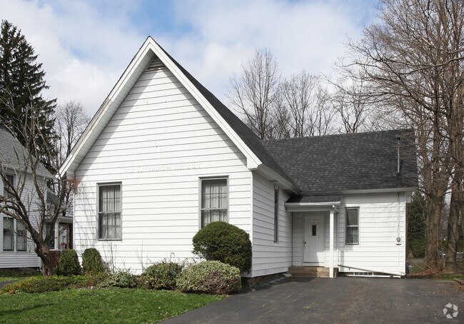
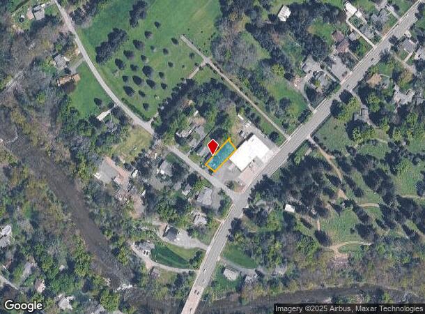
Property Record
6581 Stevens Rd, Hamburg, NY 14075

NEARBY LISTINGS FOR SALE OR LEASE
Property Detail
6581 Stevens Rd
144889-195-150-0001-007-000
Holland Land Companys Survey
Religious
Erie
X
New York
36029C0478H
7.000
2025
0.21 AC
2024
South
013400
Buffalo/Niagara Falls
1,512 SF
Buffalo-Cheektowaga-Niagara Falls, NY
DEMOGRAPHICS near 6581 Stevens Rd
1 Mile
3 Mile
5 Mile
2024 Total Population
3,051
25,814
63,949
2029 Population
3,030
25,945
64,131
Pop Growth 2024-2029
(0.69%)
+ 0.51%
+ 0.28%
Average Age
43
43
44
2024 Total Households
1,243
10,641
26,701
HH Growth 2024-2029
(0.80%)
+ 0.38%
+ 0.21%
Median Household Inc
$103,872
$87,411
$78,960
Avg Household Size
2.30
2.40
2.30
2024 Avg HH Vehicles
2.00
2.00
2.00
Median Home Value
$269,437
$250,060
$237,162
Median Year Built
1948
1968
1974
Nearby Places
- Restaurants
- Banks
- Shops
- Fitness
- Groceries
PUBLIC TRANSPORTATION
AIRPORT
Buffalo Niagara International
DRIVE
WALK
Distance
Buffalo Niagara International
35 min
22.2 mi
Niagara Falls International
DRIVE
WALK
Distance
Niagara Falls International
53 min
33.6 mi
Freight Ports
Port of Toledo
DRIVE
WALK
Distance
Port of Toledo
347 min
291.6 mi
Nearby Properties
Address
Land Use
TOTAL SIZE
Lot Size
Zoning
Address
Land Use
TOTAL SIZE
Lot Size
Zoning
14,835 SF
215.22 AC
C2
Address
Land Use
TOTAL SIZE
Lot Size
Zoning
407.90 AC
Address
Land Use
TOTAL SIZE
Lot Size
Zoning
218,461 SF
27.59 AC
C2
Address
Land Use
TOTAL SIZE
Lot Size
Zoning
157,973 SF
16.50 AC
Address
Land Use
TOTAL SIZE
Lot Size
Zoning
49.70 AC
02 - SINGL
Address
Land Use
TOTAL SIZE
Lot Size
Zoning
137,276 SF
5.10 AC
Address
Land Use
TOTAL SIZE
Lot Size
Zoning
7,448 SF
12.16 AC
Address
Land Use
TOTAL SIZE
Lot Size
Zoning
74,669 SF
9.23 AC
Address
Land Use
TOTAL SIZE
Lot Size
Zoning
136,770 SF
15.20 AC
Address
Land Use
TOTAL SIZE
Lot Size
Zoning
24.50 AC
Address
Land Use
TOTAL SIZE
Lot Size
Zoning
4,664 SF
18.10 AC
R3
Address
Land Use
TOTAL SIZE
Lot Size
Zoning
7,354 SF
10.79 AC
R3
Address
Land Use
TOTAL SIZE
Lot Size
Zoning
Address
Land Use
TOTAL SIZE
Lot Size
Zoning
Address
Land Use
TOTAL SIZE
Lot Size
Zoning
14,978 SF
3.80 AC
C2
Address
Land Use
TOTAL SIZE
Lot Size
Zoning
4.60 AC
Address
Land Use
TOTAL SIZE
Lot Size
Zoning
84,500 SF
8.20 AC
R3
Address
Land Use
TOTAL SIZE
Lot Size
Zoning
57,339 SF
2.90 AC
Address
Land Use
TOTAL SIZE
Lot Size
Zoning
Address
Land Use
TOTAL SIZE
Lot Size
Zoning
29,088 SF
5 AC
C2
Address
Land Use
TOTAL SIZE
Lot Size
Zoning
Address
Land Use
TOTAL SIZE
Lot Size
Zoning
Address
Land Use
TOTAL SIZE
Lot Size
Zoning
Address
Land Use
TOTAL SIZE
Lot Size
Zoning
19,768 SF
8.80 AC
A1
Address
Land Use
TOTAL SIZE
Lot Size
Zoning
59,772 SF
6.68 AC
C2
Address
Land Use
TOTAL SIZE
Lot Size
Zoning
11,319 SF
6.60 AC
Address
Land Use
TOTAL SIZE
Lot Size
Zoning
22,932 SF
5.60 AC
Address
Land Use
TOTAL SIZE
Lot Size
Zoning
2,462 SF
11.19 AC
R3
Address
Land Use
TOTAL SIZE
Lot Size
Zoning
58,332 SF
6.45 AC
C1
Address
Land Use
TOTAL SIZE
Lot Size
Zoning
The World's #1 Commercial Real Estate Marketplace
Connect with us
© 2025 CoStar Group
The information above has been obtained from sources believed reliable. While we do not doubt its accuracy we have not verified it and make no guarantee, warranty or representation about it. It is your responsibility to independently confirm its accuracy and completeness. Any projections, opinions, assumptions, or estimates used are for example only and do not represent the current or future performance of the property. The value of this transaction to you depends on tax and other factors which should be evaluated by your tax, financial, and legal advisors. You and your advisors should conduct a careful, independent investigation of the property to determine to your satisfaction the suitability of the property for your needs.