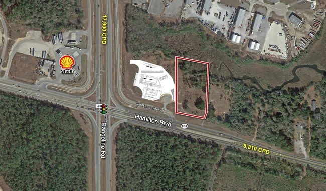
Property Record
6585 Rangeline Rd, Theodore, AL 36582

Property Detail
6585 Rangeline Rd
Mobile, AL
LOT 15 HURRICANE BAY IN MBK 71/16 LESS AND EXCEPT THT PT INTO HAMILTON BLVD #SEC 1 T6S R1W #MP39 02 01 0 005
39-02-01-0-005-015
Mobile
Conveniencestore
Alabama
AE The base floodplain where base flood elevations are provided. AE Zones are now used on new format FIRMs instead of A1-A30 Zones.
15
2025
6.91 AC
2025
Outlying Mobile County
007000
Mobile
5,588 SF
NEARBY LISTINGS FOR SALE OR LEASE
DEMOGRAPHICS near 6585 Rangeline Rd
1 mile
3 mile
5 mile
2025 Total Population
400
6,509
31,165
2030 Population
403
6,542
31,130
Pop Growth 2025-2030
+ 0.75%
+ 0.51%
(0.11%)
Average Age
45
43
41
2025 Total Households
159
2,635
12,392
HH Growth 2025-2030
+ 0.63%
+ 0.53%
(0.15%)
Median Household Inc
$78,226
$70,925
$56,523
Avg Household Size
2.40
2.40
2.40
2025 Avg HH Vehicles
2.00
2.00
2.00
Median Home Value
$450,000
$278,811
$180,522
Median Year Built
1994
1984
1979
Nearby Places
Map Layers
Map Styles
 Street
 Aerial
Layers
 Traffic
 Biking
Places
Listings with unknown addresses are not visible on the map
- Restaurants
- Banks
- Shops
- Fitness
- Groceries
PUBLIC TRANSPORTATION
AIRPORT
Mobile International
Drive
Walk
Distance
Mobile International
16 min
10.6 mi
Mobile Regional
Drive
Walk
Distance
Mobile Regional
32 min
16.4 mi
SALE & LEASE HISTORY
LISTING DATE
SALE/LEASE

Oct 10, 2016
For Sale
Mar 29, 2017
For Sale
Mar 29, 2017
For Lease
Jul 26, 2017
For Sale
Nearby Properties
Address
Land Use
TOTAL SIZE
Lot Size
Zoning
Address
Land Use
TOTAL SIZE
Lot Size
Zoning
127,658 SF
52 AC
Address
Land Use
TOTAL SIZE
Lot Size
Zoning
118,956 SF
9.90 AC
Address
Land Use
TOTAL SIZE
Lot Size
Zoning
102,400 SF
23.99 AC
Address
Land Use
TOTAL SIZE
Lot Size
Zoning
39,348 SF
100.44 AC
Address
Land Use
TOTAL SIZE
Lot Size
Zoning
82,948 SF
39.21 AC
Address
Land Use
TOTAL SIZE
Lot Size
Zoning
78,750 SF
27.51 AC
Address
Land Use
TOTAL SIZE
Lot Size
Zoning
35,508 SF
92.85 AC
Address
Land Use
TOTAL SIZE
Lot Size
Zoning
74,374 SF
7.06 AC
Address
Land Use
TOTAL SIZE
Lot Size
Zoning
234,275 SF
40.29 AC
Address
Land Use
TOTAL SIZE
Lot Size
Zoning
132,400 SF
23 AC
Address
Land Use
TOTAL SIZE
Lot Size
Zoning
78,750 SF
24 AC
Address
Land Use
TOTAL SIZE
Lot Size
Zoning
47,368 SF
45.38 AC
Address
Land Use
TOTAL SIZE
Lot Size
Zoning
15,200 SF
79.74 AC
Address
Land Use
TOTAL SIZE
Lot Size
Zoning
185.25 AC
Address
Land Use
TOTAL SIZE
Lot Size
Zoning
396.69 AC
Address
Land Use
TOTAL SIZE
Lot Size
Zoning
16,448 SF
9.30 AC
Address
Land Use
TOTAL SIZE
Lot Size
Zoning
440 SF
19.38 AC
Address
Land Use
TOTAL SIZE
Lot Size
Zoning
76,560 SF
27.88 AC
Address
Land Use
TOTAL SIZE
Lot Size
Zoning
158,516 SF
9.15 AC
Address
Land Use
TOTAL SIZE
Lot Size
Zoning
37,800 SF
10 AC
Address
Land Use
TOTAL SIZE
Lot Size
Zoning
66,608 SF
6.24 AC
Address
Land Use
TOTAL SIZE
Lot Size
Zoning
75,000 SF
8.60 AC
Address
Land Use
TOTAL SIZE
Lot Size
Zoning
63,366 SF
19 AC
Address
Land Use
TOTAL SIZE
Lot Size
Zoning
150,000 SF
7.96 AC
Address
Land Use
TOTAL SIZE
Lot Size
Zoning
992 SF
46.54 AC
Address
Land Use
TOTAL SIZE
Lot Size
Zoning
82,968 SF
32.37 AC
Address
Land Use
TOTAL SIZE
Lot Size
Zoning
222,300 SF
16.04 AC
Address
Land Use
TOTAL SIZE
Lot Size
Zoning
13,432 SF
9.34 AC
Address
Land Use
TOTAL SIZE
Lot Size
Zoning
16,500 SF
6.98 AC
Address
Land Use
TOTAL SIZE
Lot Size
Zoning
102,680 SF
19.95 AC
The World's #1 Commercial Real Estate Marketplace
Connect with us
© 2026 CoStar Group
The information above has been obtained from sources believed reliable. While we do not doubt its accuracy we have not verified it and make no guarantee, warranty or representation about it. It is your responsibility to independently confirm its accuracy and completeness. Any projections, opinions, assumptions, or estimates used are for example only and do not represent the current or future performance of the property. The value of this transaction to you depends on tax and other factors which should be evaluated by your tax, financial, and legal advisors. You and your advisors should conduct a careful, independent investigation of the property to determine to your satisfaction the suitability of the property for your needs.