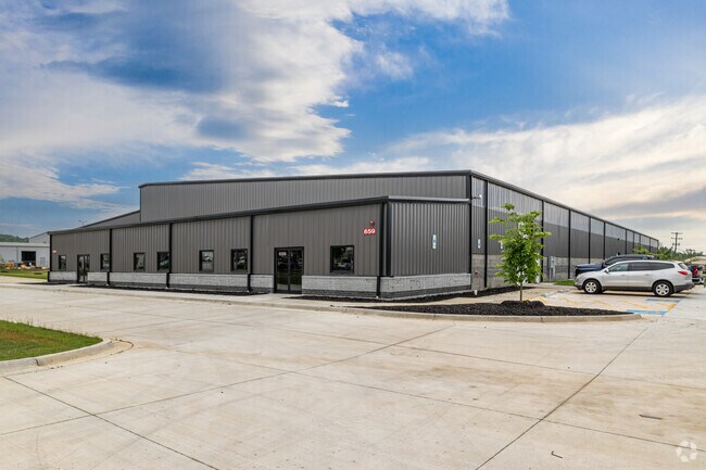
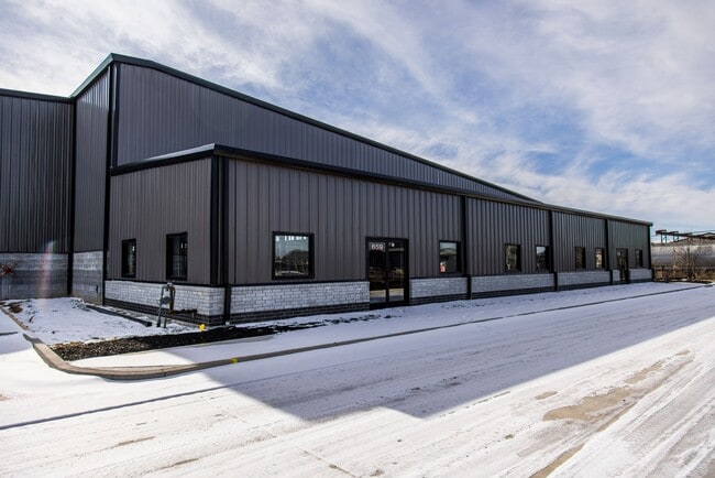
Property Record
659 E Randall Wobbe Ln, Springdale, AR 72764

Current Lease Availabilities
Property Detail
659 E Randall Wobbe Ln
815-29637-000
PT NE SE 4.75 AC FURTHER DESCRIBED FROM 2020-15040 AS: PART OF THE NE OF THE SE OF SECTION 25, TOWNSHIP 18 NORTH, RANGE 30 WE
Warehouse
Washington
I2
Arkansas
B and X Area of moderate flood hazard, usually the area between the limits of the 100-year and 500-year floods.
4.75 AC
2025
Greater Springdale
2025
Fayetteville/Springdale/Rogers
010202
Fayetteville-Springdale-Rogers, AR
62,351 SF
NEARBY LISTINGS FOR SALE OR LEASE
DEMOGRAPHICS near 659 E Randall Wobbe Ln
1 mile
3 mile
5 mile
2025 Total Population
9,533
62,204
105,512
2030 Population
10,282
66,559
113,373
Pop Growth 2025-2030
+ 7.86%
+ 7.00%
+ 7.45%
Average Age
33
34
35
2025 Total Households
2,809
18,678
34,117
HH Growth 2025-2030
+ 8.08%
+ 7.10%
+ 7.65%
Median Household Inc
$55,838
$61,509
$70,965
Avg Household Size
3.30
3.20
3.00
2025 Avg HH Vehicles
2.00
2.00
2.00
Median Home Value
$214,689
$240,967
$279,908
Median Year Built
1995
1991
1995
Nearby Places
Map Layers
Map Styles
 Street
 Aerial
Layers
 Traffic
 Biking
Places
Listings with unknown addresses are not visible on the map
- Restaurants
- Banks
- Shops
- Fitness
- Groceries
PUBLIC TRANSPORTATION
AIRPORT
Northwest Arkansas Ntl
Drive
Walk
Distance
Northwest Arkansas Ntl
33 min
16.4 mi
Freight Ports
Tulsa Port of Inola
Drive
Walk
Distance
Tulsa Port of Inola
107 min
89.5 mi
Nearby Properties
Address
Land Use
TOTAL SIZE
Lot Size
Zoning
Address
Land Use
TOTAL SIZE
Lot Size
Zoning
58,764 SF
1.56 AC
Address
Land Use
TOTAL SIZE
Lot Size
Zoning
403,089 SF
1.93 AC
Address
Land Use
TOTAL SIZE
Lot Size
Zoning
481,800 SF
40 AC
Address
Land Use
TOTAL SIZE
Lot Size
Zoning
153,718 SF
Address
Land Use
TOTAL SIZE
Lot Size
Zoning
341,266 SF
17.61 AC
Address
Land Use
TOTAL SIZE
Lot Size
Zoning
191,100 SF
10.03 AC
Address
Land Use
TOTAL SIZE
Lot Size
Zoning
117,690 SF
2.38 AC
Address
Land Use
TOTAL SIZE
Lot Size
Zoning
292,470 SF
17.27 AC
Address
Land Use
TOTAL SIZE
Lot Size
Zoning
174,333 SF
25 AC
I1I2
Address
Land Use
TOTAL SIZE
Lot Size
Zoning
134,342 SF
14.95 AC
Address
Land Use
TOTAL SIZE
Lot Size
Zoning
16,698 SF
1.11 AC
Address
Land Use
TOTAL SIZE
Lot Size
Zoning
178,140 SF
4.39 AC
Address
Land Use
TOTAL SIZE
Lot Size
Zoning
180,412 SF
13.14 AC
Address
Land Use
TOTAL SIZE
Lot Size
Zoning
117,196 SF
9.74 AC
Address
Land Use
TOTAL SIZE
Lot Size
Zoning
224,408 SF
9.80 AC
I1
Address
Land Use
TOTAL SIZE
Lot Size
Zoning
73,436 SF
16.01 AC
I1
Address
Land Use
TOTAL SIZE
Lot Size
Zoning
206,446 SF
17.14 AC
Address
Land Use
TOTAL SIZE
Lot Size
Zoning
31,150 SF
3.74 AC
C1
Address
Land Use
TOTAL SIZE
Lot Size
Zoning
182,415 SF
68.93 AC
Address
Land Use
TOTAL SIZE
Lot Size
Zoning
182,415 SF
12.04 AC
Address
Land Use
TOTAL SIZE
Lot Size
Zoning
80,475 SF
0.45 AC
C3
Address
Land Use
TOTAL SIZE
Lot Size
Zoning
73,711 SF
3.59 AC
Address
Land Use
TOTAL SIZE
Lot Size
Zoning
147,762 SF
Address
Land Use
TOTAL SIZE
Lot Size
Zoning
352,195 SF
15 AC
Address
Land Use
TOTAL SIZE
Lot Size
Zoning
54,460 SF
6.38 AC
Address
Land Use
TOTAL SIZE
Lot Size
Zoning
153,968 SF
21 AC
Address
Land Use
TOTAL SIZE
Lot Size
Zoning
364,696 SF
4.49 AC
Address
Land Use
TOTAL SIZE
Lot Size
Zoning
189,244 SF
11.16 AC
I2
Address
Land Use
TOTAL SIZE
Lot Size
Zoning
55,663 SF
2.54 AC
Address
Land Use
TOTAL SIZE
Lot Size
Zoning
162,000 SF
16 AC
I2
The World's #1 Commercial Real Estate Marketplace
Connect with us
© 2026 CoStar Group
The information above has been obtained from sources believed reliable. While we do not doubt its accuracy we have not verified it and make no guarantee, warranty or representation about it. It is your responsibility to independently confirm its accuracy and completeness. Any projections, opinions, assumptions, or estimates used are for example only and do not represent the current or future performance of the property. The value of this transaction to you depends on tax and other factors which should be evaluated by your tax, financial, and legal advisors. You and your advisors should conduct a careful, independent investigation of the property to determine to your satisfaction the suitability of the property for your needs.