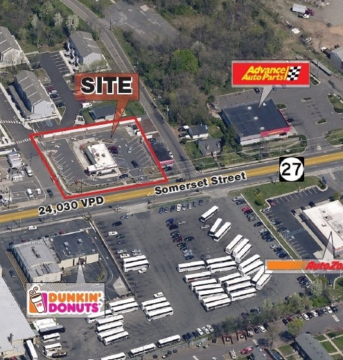
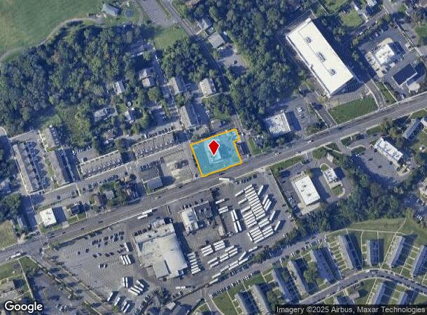
Property Record
659 State Route 27 St, Somerset, NJ 08873
NEARBY LISTINGS FOR SALE OR LEASE
Property Detail
659 State Route 27 St
08-00151-0000-00012-01
Somerset
Restaurantdrivein
New Jersey
X
12.1
34023C0126F
0.61 AC
2024
Somerset
2025
Northern New Jersey
372900
Newark, NJ-PA
2,766 SF
DEMOGRAPHICS near 659 State Route 27 St
1 Mile
3 Mile
5 Mile
2024 Total Population
20,575
132,952
254,501
2029 Population
20,228
132,096
253,337
Pop Growth 2024-2029
(1.69%)
(0.64%)
(0.46%)
Average Age
35
36
38
2024 Total Households
5,962
42,988
85,266
HH Growth 2024-2029
(1.64%)
(0.40%)
(0.35%)
Median Household Inc
$65,186
$81,838
$96,911
Avg Household Size
3.20
2.70
2.70
2024 Avg HH Vehicles
1.00
2.00
2.00
Median Home Value
$290,702
$370,495
$391,612
Median Year Built
1965
1971
1974
Nearby Places
Map Layers
Map Styles
 Street
 Aerial
- Restaurants
- Banks
- Shops
- Fitness
- Groceries
PUBLIC TRANSPORTATION
COMMUTER RAIL
Jersey Avenue (Northeast Corridor Line - NJ Transit Commuter Rail (NJ Transit))
DRIVE
WALK
Distance
Jersey Avenue (Northeast Corridor Line - NJ Transit Commuter Rail (NJ Transit))
8 min
1.3 mi
New Brunswick (Northeast Corridor Line - NJ Transit Commuter Rail (NJ Transit))
DRIVE
WALK
Distance
New Brunswick (Northeast Corridor Line - NJ Transit Commuter Rail (NJ Transit))
5 min
1.8 mi
AIRPORT
Trenton Mercer
DRIVE
WALK
Distance
Trenton Mercer
41 min
27.3 mi
Newark Liberty International
DRIVE
WALK
Distance
Newark Liberty International
41 min
30.4 mi
LaGuardia
DRIVE
WALK
Distance
LaGuardia
72 min
46.9 mi
Freight Ports
New York Container Terminal
DRIVE
WALK
Distance
New York Container Terminal
36 min
23.2 mi
SALE & LEASE HISTORY
LISTING DATE
SALE/LEASE

Apr 20, 2018
For Lease
Apr 20, 2018
For Sale
Nearby Properties
Address
Land Use
TOTAL SIZE
Lot Size
Zoning
Address
Land Use
TOTAL SIZE
Lot Size
Zoning
8.25 AC
D-HI
Address
Land Use
TOTAL SIZE
Lot Size
Zoning
Address
Land Use
TOTAL SIZE
Lot Size
Zoning
38,536 SF
149.61 AC
IN-2
Address
Land Use
TOTAL SIZE
Lot Size
Zoning
145,522 SF
97.30 AC
E
Address
Land Use
TOTAL SIZE
Lot Size
Zoning
25.77 AC
C-6
Address
Land Use
TOTAL SIZE
Lot Size
Zoning
11.50 AC
HI
Address
Land Use
TOTAL SIZE
Lot Size
Zoning
37.80 AC
IN-2
Address
Land Use
TOTAL SIZE
Lot Size
Zoning
99.79 AC
B-I
Address
Land Use
TOTAL SIZE
Lot Size
Zoning
77.04 AC
I2
Address
Land Use
TOTAL SIZE
Lot Size
Zoning
78.71 AC
ER
Address
Land Use
TOTAL SIZE
Lot Size
Zoning
17 AC
O-1
Address
Land Use
TOTAL SIZE
Lot Size
Zoning
21.30 AC
IN-1
Address
Land Use
TOTAL SIZE
Lot Size
Zoning
48.30 AC
GB
Address
Land Use
TOTAL SIZE
Lot Size
Zoning
16,397 SF
41.98 AC
R20
Address
Land Use
TOTAL SIZE
Lot Size
Zoning
543,945 SF
48.46 AC
B-I
Address
Land Use
TOTAL SIZE
Lot Size
Zoning
Address
Land Use
TOTAL SIZE
Lot Size
Zoning
1.15 AC
C-4
Address
Land Use
TOTAL SIZE
Lot Size
Zoning
0.25 AC
C-4
Address
Land Use
TOTAL SIZE
Lot Size
Zoning
18.21 AC
E
Address
Land Use
TOTAL SIZE
Lot Size
Zoning
0.92 AC
D-HI
Address
Land Use
TOTAL SIZE
Lot Size
Zoning
6,495 SF
5.74 AC
IN-1
Address
Land Use
TOTAL SIZE
Lot Size
Zoning
1.81 AC
D-HI
Address
Land Use
TOTAL SIZE
Lot Size
Zoning
53,900 SF
4.69 AC
IN-1
Address
Land Use
TOTAL SIZE
Lot Size
Zoning
11.35 AC
R20
Address
Land Use
TOTAL SIZE
Lot Size
Zoning
83,080 SF
12.40 AC
E
Address
Land Use
TOTAL SIZE
Lot Size
Zoning
111,911 SF
126 AC
E
Address
Land Use
TOTAL SIZE
Lot Size
Zoning
5.54 AC
C-5
Address
Land Use
TOTAL SIZE
Lot Size
Zoning
Address
Land Use
TOTAL SIZE
Lot Size
Zoning
Address
Land Use
TOTAL SIZE
Lot Size
Zoning
The World's #1 Commercial Real Estate Marketplace
Connect with us
© 2025 CoStar Group
The information above has been obtained from sources believed reliable. While we do not doubt its accuracy we have not verified it and make no guarantee, warranty or representation about it. It is your responsibility to independently confirm its accuracy and completeness. Any projections, opinions, assumptions, or estimates used are for example only and do not represent the current or future performance of the property. The value of this transaction to you depends on tax and other factors which should be evaluated by your tax, financial, and legal advisors. You and your advisors should conduct a careful, independent investigation of the property to determine to your satisfaction the suitability of the property for your needs.