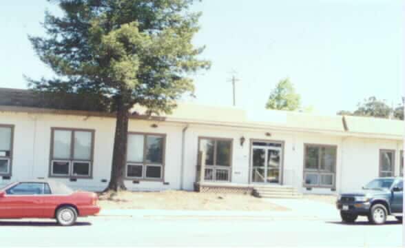
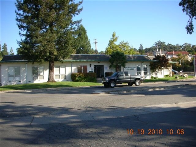
Property Record
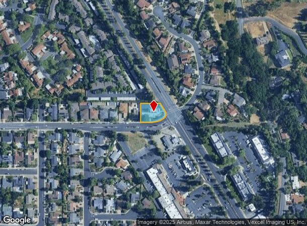
110 Blue Ridge Dr, Martinez, CA 94553

NEARBY LISTINGS FOR SALE OR LEASE
Property Detail
110 Blue Ridge Dr
164-182-027-7
Las Juntas Rho
Officebuilding
POR RO LAS JUNTAS
X
Contra Costa
06013C0280G
California
2024
0.41 AC
2025
Martinez/Pacheco/Hercules
321103
East Bay/Oakland
4,609 SF
Oakland-Hayward-Berkeley, CA
DEMOGRAPHICS near 110 Blue Ridge Dr
1 Mile
3 Mile
5 Mile
2024 Total Population
10,556
95,780
230,751
2029 Population
10,459
94,965
229,506
Pop Growth 2024-2029
(0.92%)
(0.85%)
(0.54%)
Average Age
46
41
42
2024 Total Households
4,236
37,043
91,392
HH Growth 2024-2029
(0.97%)
(0.84%)
(0.50%)
Median Household Inc
$162,318
$118,345
$118,104
Avg Household Size
2.50
2.50
2.50
2024 Avg HH Vehicles
2.00
2.00
2.00
Median Home Value
$1,007,552
$837,191
$832,570
Median Year Built
1974
1974
1972
Nearby Places
- Restaurants
- Banks
- Shops
- Fitness
- Groceries
PUBLIC TRANSPORTATION
COMMUTER RAIL
DRIVE
WALK
Distance
11 min
5.4 mi
AIRPORT
Metro Oakland International
DRIVE
WALK
Distance
Metro Oakland International
39 min
26.4 mi
San Francisco International
DRIVE
WALK
Distance
San Francisco International
57 min
38.3 mi
Freight Ports
Port of Oakland
DRIVE
WALK
Distance
Port of Oakland
28 min
19.1 mi
SALE & LEASE HISTORY
LISTING DATE
SALE/LEASE

Jan 24, 2019
For Lease
Aug 16, 2017
For Lease
Nearby Properties
Address
Land Use
TOTAL SIZE
Lot Size
Zoning
Address
Land Use
TOTAL SIZE
Lot Size
Zoning
489,813 SF
38.82 AC
Address
Land Use
TOTAL SIZE
Lot Size
Zoning
34,226 SF
30 AC
Address
Land Use
TOTAL SIZE
Lot Size
Zoning
57.67 AC
HI
Address
Land Use
TOTAL SIZE
Lot Size
Zoning
12.82 AC
Address
Land Use
TOTAL SIZE
Lot Size
Zoning
31,614 SF
24.46 AC
Address
Land Use
TOTAL SIZE
Lot Size
Zoning
38,694 SF
2.33 AC
Address
Land Use
TOTAL SIZE
Lot Size
Zoning
234,624 SF
6.63 AC
Address
Land Use
TOTAL SIZE
Lot Size
Zoning
70,000 SF
25.77 AC
Address
Land Use
TOTAL SIZE
Lot Size
Zoning
112,000 SF
18.40 AC
Address
Land Use
TOTAL SIZE
Lot Size
Zoning
192,387 SF
17.42 AC
M17
Address
Land Use
TOTAL SIZE
Lot Size
Zoning
9,840 SF
5.85 AC
Address
Land Use
TOTAL SIZE
Lot Size
Zoning
12,864 SF
5.62 AC
Address
Land Use
TOTAL SIZE
Lot Size
Zoning
100,627 SF
6.47 AC
Address
Land Use
TOTAL SIZE
Lot Size
Zoning
45,744 SF
9.49 AC
Address
Land Use
TOTAL SIZE
Lot Size
Zoning
164,517 SF
3.65 AC
Address
Land Use
TOTAL SIZE
Lot Size
Zoning
225,367 SF
7.42 AC
Address
Land Use
TOTAL SIZE
Lot Size
Zoning
86,074 SF
2.17 AC
Address
Land Use
TOTAL SIZE
Lot Size
Zoning
92,550 SF
3.88 AC
Address
Land Use
TOTAL SIZE
Lot Size
Zoning
22,152 SF
5.51 AC
Address
Land Use
TOTAL SIZE
Lot Size
Zoning
184,929 SF
2.34 AC
P1
Address
Land Use
TOTAL SIZE
Lot Size
Zoning
3,612 SF
4.74 AC
Address
Land Use
TOTAL SIZE
Lot Size
Zoning
146,085 SF
8.69 AC
Address
Land Use
TOTAL SIZE
Lot Size
Zoning
83,969 SF
2.43 AC
Address
Land Use
TOTAL SIZE
Lot Size
Zoning
206,000 SF
1.76 AC
P1
Address
Land Use
TOTAL SIZE
Lot Size
Zoning
482.84 AC
U
Address
Land Use
TOTAL SIZE
Lot Size
Zoning
79,030 SF
1.54 AC
P1
Address
Land Use
TOTAL SIZE
Lot Size
Zoning
60,000 SF
4.51 AC
Address
Land Use
TOTAL SIZE
Lot Size
Zoning
22.30 AC
Address
Land Use
TOTAL SIZE
Lot Size
Zoning
255,088 SF
4.89 AC
P1
Address
Land Use
TOTAL SIZE
Lot Size
Zoning
87,357 SF
6.38 AC
P1
The World's #1 Commercial Real Estate Marketplace
Connect with us
© 2025 CoStar Group
The information above has been obtained from sources believed reliable. While we do not doubt its accuracy we have not verified it and make no guarantee, warranty or representation about it. It is your responsibility to independently confirm its accuracy and completeness. Any projections, opinions, assumptions, or estimates used are for example only and do not represent the current or future performance of the property. The value of this transaction to you depends on tax and other factors which should be evaluated by your tax, financial, and legal advisors. You and your advisors should conduct a careful, independent investigation of the property to determine to your satisfaction the suitability of the property for your needs.