Property Record
66 Forest Grove Rd, Coraopolis, PA 15108


Property Detail
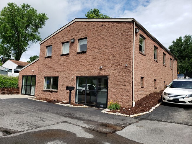
66 Forest Grove Rd
Pittsburgh, PA
LOT 87.47X AVG 177.99X88.45 RR FOREST GROVE RD 1 STY BLOCK OFFICE BLDG #66
0208-A-00289-0000-00
Allegheny
Medicalbuilding
Pennsylvania
B and X Area of moderate flood hazard, usually the area between the limits of the 100-year and 500-year floods.
289
2024
0.37 AC
2025
West Pittsburgh
459102
Pittsburgh
NEARBY LISTINGS FOR SALE OR LEASE
DEMOGRAPHICS near 66 Forest Grove Rd
1 mile
3 mile
5 mile
2025 Total Population
5,620
36,608
119,721
2030 Population
5,593
36,267
118,152
Pop Growth 2025-2030
(0.48%)
(0.93%)
(1.31%)
Average Age
44
43
42
2025 Total Households
2,190
15,717
53,542
HH Growth 2025-2030
(0.64%)
(0.97%)
(1.42%)
Median Household Inc
$103,409
$86,492
$76,542
Avg Household Size
2.50
2.30
2.20
2025 Avg HH Vehicles
2.00
2.00
2.00
Median Home Value
$324,637
$264,369
$238,749
Median Year Built
1978
1971
1959
Nearby Places
Map Layers
Map Styles
 Street
 Aerial
Layers
 Traffic
 Biking
Places
Listings with unknown addresses are not visible on the map
- Restaurants
- Banks
- Shops
- Fitness
- Groceries
PUBLIC TRANSPORTATION
COMMUTER RAIL
Drive
Walk
Distance
20 min
9.2 mi
AIRPORT
Pittsburgh International
Drive
Walk
Distance
Pittsburgh International
20 min
7.4 mi
SALE & LEASE HISTORY
LISTING DATE
SALE/LEASE

Jun 25, 2019
For Lease
Nearby Properties
Address
Land Use
TOTAL SIZE
Lot Size
Zoning
Address
Land Use
TOTAL SIZE
Lot Size
Zoning
105.09 AC
Address
Land Use
TOTAL SIZE
Lot Size
Zoning
61.94 AC
Address
Land Use
TOTAL SIZE
Lot Size
Zoning
75.22 AC
Address
Land Use
TOTAL SIZE
Lot Size
Zoning
33.43 AC
Address
Land Use
TOTAL SIZE
Lot Size
Zoning
Address
Land Use
TOTAL SIZE
Lot Size
Zoning
20.19 AC
Address
Land Use
TOTAL SIZE
Lot Size
Zoning
Address
Land Use
TOTAL SIZE
Lot Size
Zoning
Address
Land Use
TOTAL SIZE
Lot Size
Zoning
20.40 AC
Address
Land Use
TOTAL SIZE
Lot Size
Zoning
25.09 AC
Address
Land Use
TOTAL SIZE
Lot Size
Zoning
Address
Land Use
TOTAL SIZE
Lot Size
Zoning
10.60 AC
Address
Land Use
TOTAL SIZE
Lot Size
Zoning
Address
Land Use
TOTAL SIZE
Lot Size
Zoning
5.32 AC
Address
Land Use
TOTAL SIZE
Lot Size
Zoning
Address
Land Use
TOTAL SIZE
Lot Size
Zoning
11.93 AC
Address
Land Use
TOTAL SIZE
Lot Size
Zoning
12.69 AC
Address
Land Use
TOTAL SIZE
Lot Size
Zoning
Address
Land Use
TOTAL SIZE
Lot Size
Zoning
Address
Land Use
TOTAL SIZE
Lot Size
Zoning
8.31 AC
Address
Land Use
TOTAL SIZE
Lot Size
Zoning
23.73 AC
Address
Land Use
TOTAL SIZE
Lot Size
Zoning
42.80 AC
Address
Land Use
TOTAL SIZE
Lot Size
Zoning
6.40 AC
Address
Land Use
TOTAL SIZE
Lot Size
Zoning
Address
Land Use
TOTAL SIZE
Lot Size
Zoning
39.88 AC
Address
Land Use
TOTAL SIZE
Lot Size
Zoning
14.14 AC
Address
Land Use
TOTAL SIZE
Lot Size
Zoning
5.58 AC
Address
Land Use
TOTAL SIZE
Lot Size
Zoning
48.63 AC
Address
Land Use
TOTAL SIZE
Lot Size
Zoning
55.31 AC
Address
Land Use
TOTAL SIZE
Lot Size
Zoning
The World's #1 Commercial Real Estate Marketplace
Connect with us
© 2026 CoStar Group
The information above has been obtained from sources believed reliable. While we do not doubt its accuracy we have not verified it and make no guarantee, warranty or representation about it. It is your responsibility to independently confirm its accuracy and completeness. Any projections, opinions, assumptions, or estimates used are for example only and do not represent the current or future performance of the property. The value of this transaction to you depends on tax and other factors which should be evaluated by your tax, financial, and legal advisors. You and your advisors should conduct a careful, independent investigation of the property to determine to your satisfaction the suitability of the property for your needs.