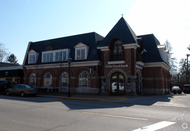
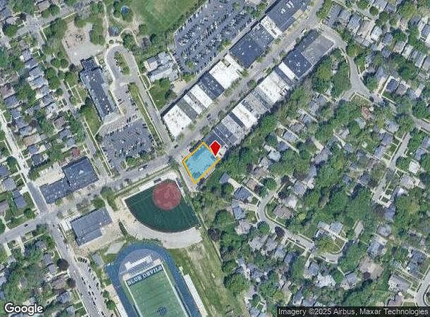
Property Record
66 Kercheval Ave, Grosse Pointe Farms, MI 48236

NEARBY LISTINGS FOR SALE OR LEASE
Property Detail
66 Kercheval Ave
Detroit-Warren-Dearborn, MI
Radnor Park
38-014-01-0173-000
FMZB173 TO 177 LOTS 173 TO 177 INCL RADNOR PARK SUB PC 258,584 L65 P80 WCR
Financialbuilding
Wayne
X
Michigan
26163C0144F
173-177
2025
0.30 AC
2025
The Pointes/Harper Woods
550600
Detroit
5,911 SF
DEMOGRAPHICS near 66 Kercheval Ave
1 Mile
3 Mile
5 Mile
2024 Total Population
11,224
79,255
187,972
2029 Population
10,724
77,565
186,799
Pop Growth 2024-2029
(4.45%)
(2.13%)
(0.62%)
Average Age
43
40
39
2024 Total Households
4,350
30,278
72,812
HH Growth 2024-2029
(4.44%)
(2.20%)
(0.80%)
Median Household Inc
$147,086
$67,617
$52,928
Avg Household Size
2.50
2.60
2.50
2024 Avg HH Vehicles
2.00
2.00
1.00
Median Home Value
$397,560
$245,094
$160,217
Median Year Built
1947
1948
1951
Nearby Places
Map Layers
Map Styles
 Street
 Aerial
- Restaurants
- Banks
- Shops
- Fitness
- Groceries
PUBLIC TRANSPORTATION
AIRPORT
Windsor International
DRIVE
WALK
Distance
Windsor International
45 min
18.3 mi
Detroit Metro Wayne County
DRIVE
WALK
Distance
Detroit Metro Wayne County
51 min
32.1 mi
Freight Ports
DRIVE
WALK
Distance
96 min
72.9 mi
Nearby Properties
Address
Land Use
TOTAL SIZE
Lot Size
Zoning
Address
Land Use
TOTAL SIZE
Lot Size
Zoning
211,065 SF
8.84 AC
C.F
Address
Land Use
TOTAL SIZE
Lot Size
Zoning
575,081 SF
8.53 AC
R6
Address
Land Use
TOTAL SIZE
Lot Size
Zoning
101,733 SF
1.10 AC
C-2
Address
Land Use
TOTAL SIZE
Lot Size
Zoning
49,437 SF
0.47 AC
Address
Land Use
TOTAL SIZE
Lot Size
Zoning
93,296 SF
1.05 AC
C-2
Address
Land Use
TOTAL SIZE
Lot Size
Zoning
62,195 SF
1.50 AC
Address
Land Use
TOTAL SIZE
Lot Size
Zoning
17,558 SF
3.15 AC
Address
Land Use
TOTAL SIZE
Lot Size
Zoning
41,000 SF
C-1
Address
Land Use
TOTAL SIZE
Lot Size
Zoning
89,897 SF
2.23 AC
Address
Land Use
TOTAL SIZE
Lot Size
Zoning
28,055 SF
0.44 AC
Address
Land Use
TOTAL SIZE
Lot Size
Zoning
42,113 SF
0.54 AC
Address
Land Use
TOTAL SIZE
Lot Size
Zoning
102,205 SF
214.30 AC
Address
Land Use
TOTAL SIZE
Lot Size
Zoning
20,625 SF
0.48 AC
C-2
Address
Land Use
TOTAL SIZE
Lot Size
Zoning
47,227 SF
6.29 AC
PD
Address
Land Use
TOTAL SIZE
Lot Size
Zoning
10,704 SF
1.84 AC
Address
Land Use
TOTAL SIZE
Lot Size
Zoning
25,500 SF
0.23 AC
Address
Land Use
TOTAL SIZE
Lot Size
Zoning
101,814 SF
3.74 AC
R-2
Address
Land Use
TOTAL SIZE
Lot Size
Zoning
60,484 SF
4.85 AC
PD
Address
Land Use
TOTAL SIZE
Lot Size
Zoning
43,967 SF
2.80 AC
O-1
Address
Land Use
TOTAL SIZE
Lot Size
Zoning
16.16 AC
PD
Address
Land Use
TOTAL SIZE
Lot Size
Zoning
14,820 SF
0.41 AC
C-1
Address
Land Use
TOTAL SIZE
Lot Size
Zoning
18,113 SF
0.42 AC
C-2
Address
Land Use
TOTAL SIZE
Lot Size
Zoning
6,152 SF
4.30 AC
Address
Land Use
TOTAL SIZE
Lot Size
Zoning
24,120 SF
4.89 AC
B4
Address
Land Use
TOTAL SIZE
Lot Size
Zoning
10,630 SF
0.20 AC
C-2
Address
Land Use
TOTAL SIZE
Lot Size
Zoning
140,160 SF
0.62 AC
Address
Land Use
TOTAL SIZE
Lot Size
Zoning
16,142 SF
0.76 AC
Address
Land Use
TOTAL SIZE
Lot Size
Zoning
35,296 SF
0.31 AC
R2
Address
Land Use
TOTAL SIZE
Lot Size
Zoning
8,180 SF
0.43 AC
P-1
Address
Land Use
TOTAL SIZE
Lot Size
Zoning
10,438 SF
0.45 AC
R-01
The World's #1 Commercial Real Estate Marketplace
Connect with us
© 2025 CoStar Group
The information above has been obtained from sources believed reliable. While we do not doubt its accuracy we have not verified it and make no guarantee, warranty or representation about it. It is your responsibility to independently confirm its accuracy and completeness. Any projections, opinions, assumptions, or estimates used are for example only and do not represent the current or future performance of the property. The value of this transaction to you depends on tax and other factors which should be evaluated by your tax, financial, and legal advisors. You and your advisors should conduct a careful, independent investigation of the property to determine to your satisfaction the suitability of the property for your needs.