Property Record
66 Lexington Ave, Trenton, NJ 08618
NEARBY LISTINGS FOR SALE OR LEASE
-
-
-
-
-
-
No Photo
-
-
-
-
-
-
View all Trenton listings for sale on LoopNet.com
Property Detail
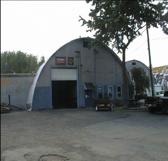
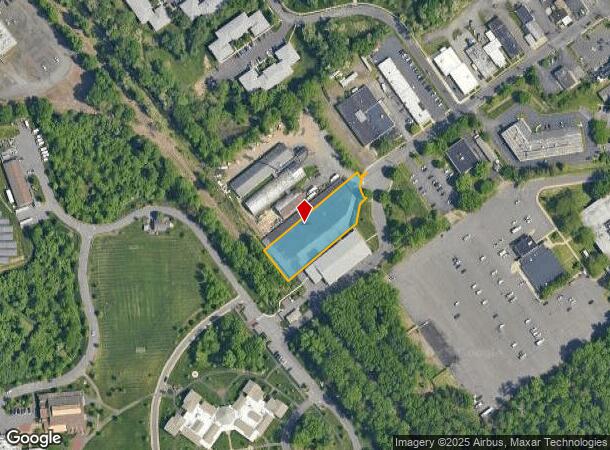
66 Lexington Ave
Trenton, NJ
Popkin & Teich Lexington Avenue
02-00320-0000-00128
UNIT 2311 BLDG 23
Warehouse
Mercer
X
New Jersey
34021C0118F
128
2024
0.90 AC
2025
Trenton/295
001401
Northern New Jersey
12,678 SF
DEMOGRAPHICS near 66 Lexington Ave
1 Mile
3 Mile
5 Mile
2024 Total Population
12,411
97,710
231,918
2029 Population
12,307
97,303
229,105
Pop Growth 2024-2029
(0.84%)
(0.42%)
(1.21%)
Average Age
42
40
40
2024 Total Households
4,777
37,677
84,164
HH Growth 2024-2029
(0.86%)
(0.53%)
(1.26%)
Median Household Inc
$71,347
$67,059
$75,816
Avg Household Size
2.30
2.40
2.60
2024 Avg HH Vehicles
2.00
2.00
2.00
Median Home Value
$184,510
$245,167
$293,091
Median Year Built
1953
1955
1957
Nearby Places
Map Layers
Map Styles
 Street
 Aerial
- Restaurants
- Banks
- Shops
- Fitness
- Groceries
PUBLIC TRANSPORTATION
COMMUTER RAIL
West Trenton (R3 - Southeastern Pennsylvania Transportation Authority Regional Rail (SEPTA Regional Rail))
DRIVE
WALK
Distance
West Trenton (R3 - Southeastern Pennsylvania Transportation Authority Regional Rail (SEPTA Regional Rail))
6 min
2.6 mi
DRIVE
WALK
Distance
8 min
3.7 mi
AIRPORT
Trenton Mercer
DRIVE
WALK
Distance
Trenton Mercer
8 min
3.4 mi
Philadelphia International
DRIVE
WALK
Distance
Philadelphia International
68 min
45.7 mi
Freight Ports
Port of Philadelphia
DRIVE
WALK
Distance
Port of Philadelphia
48 min
32.0 mi
Nearby Properties
Address
Land Use
TOTAL SIZE
Lot Size
Zoning
Address
Land Use
TOTAL SIZE
Lot Size
Zoning
67.65 AC
R-1
Address
Land Use
TOTAL SIZE
Lot Size
Zoning
8.23 AC
BA
Address
Land Use
TOTAL SIZE
Lot Size
Zoning
26 AC
HIST
Address
Land Use
TOTAL SIZE
Lot Size
Zoning
225.40 AC
R-1
Address
Land Use
TOTAL SIZE
Lot Size
Zoning
6.69 AC
BA
Address
Land Use
TOTAL SIZE
Lot Size
Zoning
1,996 SF
125 AC
RA
Address
Land Use
TOTAL SIZE
Lot Size
Zoning
5.97 AC
R-1
Address
Land Use
TOTAL SIZE
Lot Size
Zoning
879,376 SF
2.54 AC
BA
Address
Land Use
TOTAL SIZE
Lot Size
Zoning
4,320 SF
12.06 AC
PRO
Address
Land Use
TOTAL SIZE
Lot Size
Zoning
125,000 SF
3.68 AC
MU
Address
Land Use
TOTAL SIZE
Lot Size
Zoning
96.60 AC
OP-2
Address
Land Use
TOTAL SIZE
Lot Size
Zoning
117.50 AC
OP-1
Address
Land Use
TOTAL SIZE
Lot Size
Zoning
42.80 AC
IP-1
Address
Land Use
TOTAL SIZE
Lot Size
Zoning
5.38 AC
MU
Address
Land Use
TOTAL SIZE
Lot Size
Zoning
27.21 AC
PRO
Address
Land Use
TOTAL SIZE
Lot Size
Zoning
288,000 SF
1.23 AC
BA
Address
Land Use
TOTAL SIZE
Lot Size
Zoning
0.35 AC
OP
Address
Land Use
TOTAL SIZE
Lot Size
Zoning
6.11 AC
R-1
Address
Land Use
TOTAL SIZE
Lot Size
Zoning
104.60 AC
IP-1
Address
Land Use
TOTAL SIZE
Lot Size
Zoning
0.24 AC
BA
Address
Land Use
TOTAL SIZE
Lot Size
Zoning
186,960 SF
2.37 AC
BA
Address
Land Use
TOTAL SIZE
Lot Size
Zoning
24.44 AC
AT
Address
Land Use
TOTAL SIZE
Lot Size
Zoning
212,074 SF
0.82 AC
BA
Address
Land Use
TOTAL SIZE
Lot Size
Zoning
23.50 AC
R-2
Address
Land Use
TOTAL SIZE
Lot Size
Zoning
Address
Land Use
TOTAL SIZE
Lot Size
Zoning
323,087 SF
1.95 AC
PM
Address
Land Use
TOTAL SIZE
Lot Size
Zoning
161,080 SF
2.21 AC
BA
Address
Land Use
TOTAL SIZE
Lot Size
Zoning
0.32 AC
OP
Address
Land Use
TOTAL SIZE
Lot Size
Zoning
0.59 AC
RM
Address
Land Use
TOTAL SIZE
Lot Size
Zoning
11.40 AC
The World's #1 Commercial Real Estate Marketplace
Connect with us
© 2025 CoStar Group
The information above has been obtained from sources believed reliable. While we do not doubt its accuracy we have not verified it and make no guarantee, warranty or representation about it. It is your responsibility to independently confirm its accuracy and completeness. Any projections, opinions, assumptions, or estimates used are for example only and do not represent the current or future performance of the property. The value of this transaction to you depends on tax and other factors which should be evaluated by your tax, financial, and legal advisors. You and your advisors should conduct a careful, independent investigation of the property to determine to your satisfaction the suitability of the property for your needs.