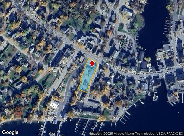
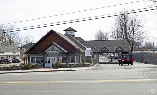
Property Record
66 N Main St, Wolfeboro, NH 03894

NEARBY LISTINGS FOR SALE OR LEASE
-
-
View all Wolfeboro listings for sale on LoopNet.com
Property Detail
66 N Main St
Commercialbuilding
Carroll
X
New Hampshire
33003C0730D
0.65 AC
2024
Concord/New Hampshire North Area
2024
Other Market Areas
956101
WOLF-000217-000122
5,340 SF
DEMOGRAPHICS near 66 N Main St
1 Mile
3 Mile
5 Mile
2024 Total Population
1,455
5,317
8,150
2029 Population
1,593
5,860
8,920
Pop Growth 2024-2029
+ 9.48%
+ 10.21%
+ 9.45%
Average Age
51
52
51
2024 Total Households
657
2,414
3,676
HH Growth 2024-2029
+ 9.28%
+ 10.11%
+ 9.30%
Median Household Inc
$52,656
$63,239
$72,178
Avg Household Size
2.10
2.10
2.10
2024 Avg HH Vehicles
1.00
2.00
2.00
Median Home Value
$370,472
$362,546
$373,003
Median Year Built
1981
1983
1981
Nearby Places
Map Layers
Map Styles
 Street
 Aerial
- Restaurants
- Banks
- Shops
- Fitness
- Groceries
Nearby Properties
Address
Land Use
TOTAL SIZE
Lot Size
Zoning
Address
Land Use
TOTAL SIZE
Lot Size
Zoning
306,273 SF
46.12 AC
COMMER
Address
Land Use
TOTAL SIZE
Lot Size
Zoning
53,306 SF
65.72 AC
WINNIP
Address
Land Use
TOTAL SIZE
Lot Size
Zoning
17.55 AC
COMMER
Address
Land Use
TOTAL SIZE
Lot Size
Zoning
1,789 SF
30.81 AC
COMMER
Address
Land Use
TOTAL SIZE
Lot Size
Zoning
17,788 SF
7.10 AC
WINNIP
Address
Land Use
TOTAL SIZE
Lot Size
Zoning
3,578 SF
78.19 AC
COMMER
Address
Land Use
TOTAL SIZE
Lot Size
Zoning
18,772 SF
5.93 AC
WINNIP
Address
Land Use
TOTAL SIZE
Lot Size
Zoning
18,179 SF
3.50 AC
WINNIP
Address
Land Use
TOTAL SIZE
Lot Size
Zoning
16,014 SF
6.20 AC
WINNIP
Address
Land Use
TOTAL SIZE
Lot Size
Zoning
1,945 SF
34.69 AC
WINNIP
Address
Land Use
TOTAL SIZE
Lot Size
Zoning
6,973 SF
14.62 AC
LR-LAK
Address
Land Use
TOTAL SIZE
Lot Size
Zoning
29,560 SF
9.48 AC
LR-LAK
Address
Land Use
TOTAL SIZE
Lot Size
Zoning
983 SF
61.40 AC
SOUTH
Address
Land Use
TOTAL SIZE
Lot Size
Zoning
13,445 SF
2.42 AC
WINNIP
Address
Land Use
TOTAL SIZE
Lot Size
Zoning
40,404 SF
2.52 AC
WINNIP
Address
Land Use
TOTAL SIZE
Lot Size
Zoning
2,124 SF
11.30 AC
LR-LAK
Address
Land Use
TOTAL SIZE
Lot Size
Zoning
11,121 SF
1.24 AC
WINNIP
Address
Land Use
TOTAL SIZE
Lot Size
Zoning
8,586 SF
1.63 AC
WINNIP
Address
Land Use
TOTAL SIZE
Lot Size
Zoning
7,763 SF
1.24 AC
LR-LAK
Address
Land Use
TOTAL SIZE
Lot Size
Zoning
1.40 AC
WINNIP
Address
Land Use
TOTAL SIZE
Lot Size
Zoning
3,085 SF
2.20 AC
WINNIP
Address
Land Use
TOTAL SIZE
Lot Size
Zoning
7,491 SF
3.45 AC
WINNIP
Address
Land Use
TOTAL SIZE
Lot Size
Zoning
10,835 SF
0.90 AC
WINNIP
Address
Land Use
TOTAL SIZE
Lot Size
Zoning
8,058 SF
1.95 AC
WINNIP
Address
Land Use
TOTAL SIZE
Lot Size
Zoning
9,384 SF
1.10 AC
WINNIP
Address
Land Use
TOTAL SIZE
Lot Size
Zoning
4,228 SF
3.81 AC
WINNWI
Address
Land Use
TOTAL SIZE
Lot Size
Zoning
8,250 SF
2.70 AC
WINNIP
Address
Land Use
TOTAL SIZE
Lot Size
Zoning
8,371 SF
3.10 AC
WINNIP
Address
Land Use
TOTAL SIZE
Lot Size
Zoning
8,535 SF
1.94 AC
WINNIP
Address
Land Use
TOTAL SIZE
Lot Size
Zoning
7,315 SF
3.14 AC
WINNWI
The World's #1 Commercial Real Estate Marketplace
Connect with us
© 2025 CoStar Group
The information above has been obtained from sources believed reliable. While we do not doubt its accuracy we have not verified it and make no guarantee, warranty or representation about it. It is your responsibility to independently confirm its accuracy and completeness. Any projections, opinions, assumptions, or estimates used are for example only and do not represent the current or future performance of the property. The value of this transaction to you depends on tax and other factors which should be evaluated by your tax, financial, and legal advisors. You and your advisors should conduct a careful, independent investigation of the property to determine to your satisfaction the suitability of the property for your needs.