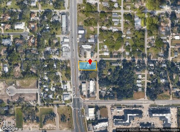
Property Record
66 Tamiami Trl, Osprey, FL 34229
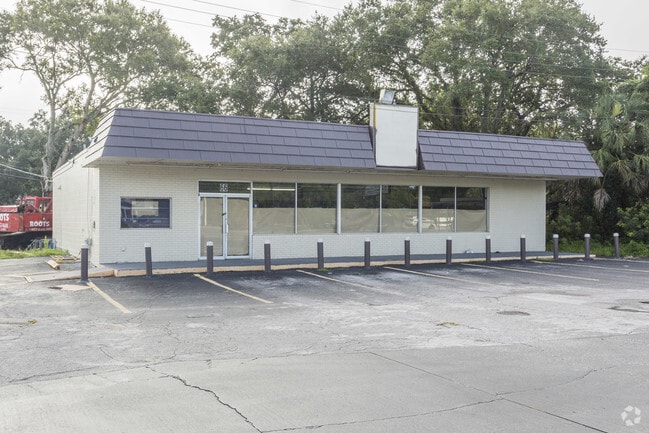
This Property Is For Sale
NEARBY LISTINGS FOR SALE OR LEASE
Property Detail
66 Tamiami Trl
North Port-Sarasota-Bradenton, FL
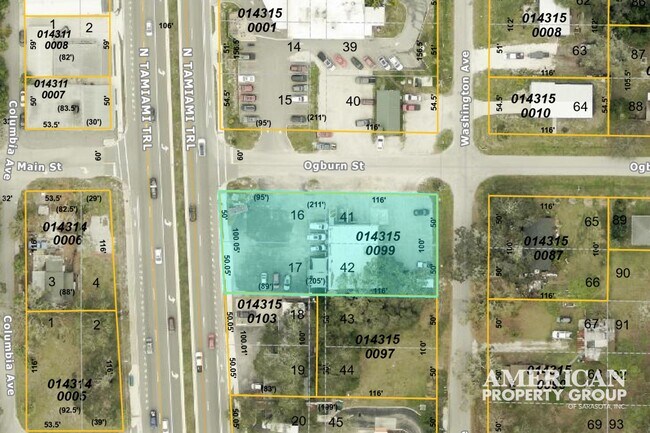
Ogburns T B Add To Town Of Osprey
0143-15-0099
LOTS 16, 17, 41 & 42, TOGETHER WITH VAC ALLEY LYING WLY OF SAID LOTS 41 & 42, OGBURNS T B ADD TO TOWN OF OSPREY, LESS ST RD R/W
Restaurantbuilding
Sarasota
X
Florida
12115C0228G
16,17
2023
0.48 AC
2024
Sarasota
002101
Tampa/St Petersburg
2,400 SF
DEMOGRAPHICS near 66 Tamiami Trl
1 Mile
3 Mile
5 Mile
2024 Total Population
2,622
27,336
62,388
2029 Population
2,993
31,833
72,684
Pop Growth 2024-2029
+ 14.15%
+ 16.45%
+ 16.50%
Average Age
57
58
56
2024 Total Households
1,339
13,944
31,399
HH Growth 2024-2029
+ 14.12%
+ 16.58%
+ 16.59%
Median Household Inc
$81,744
$88,982
$84,601
Avg Household Size
1.90
1.90
1.90
2024 Avg HH Vehicles
2.00
2.00
2.00
Median Home Value
$606,635
$476,960
$419,727
Median Year Built
1999
1995
1990
Nearby Places
- Restaurants
- Banks
- Shops
- Fitness
- Groceries
PUBLIC TRANSPORTATION
AIRPORT
Sarasota/Bradenton International
DRIVE
WALK
Distance
Sarasota/Bradenton International
29 min
15.8 mi
Freight Ports
Port Manatee
DRIVE
WALK
Distance
Port Manatee
51 min
37.0 mi
Nearby Properties
Address
Land Use
TOTAL SIZE
Lot Size
Zoning
Address
Land Use
TOTAL SIZE
Lot Size
Zoning
530,029 SF
14.92 AC
RMF4
Address
Land Use
TOTAL SIZE
Lot Size
Zoning
289,996 SF
20.95 AC
RMF3
Address
Land Use
TOTAL SIZE
Lot Size
Zoning
318,414 SF
22.35 AC
RMF1
Address
Land Use
TOTAL SIZE
Lot Size
Zoning
242,685 SF
26.67 AC
RMF1
Address
Land Use
TOTAL SIZE
Lot Size
Zoning
312,294 SF
40.21 AC
OPI
Address
Land Use
TOTAL SIZE
Lot Size
Zoning
195,192 SF
73.19 AC
GU
Address
Land Use
TOTAL SIZE
Lot Size
Zoning
175,813 SF
10.09 AC
CG
Address
Land Use
TOTAL SIZE
Lot Size
Zoning
17,785 SF
56.32 AC
RMF2
Address
Land Use
TOTAL SIZE
Lot Size
Zoning
148,339 SF
12.86 AC
CG
Address
Land Use
TOTAL SIZE
Lot Size
Zoning
123,338 SF
8.53 AC
OPI
Address
Land Use
TOTAL SIZE
Lot Size
Zoning
124,546 SF
76 AC
GU
Address
Land Use
TOTAL SIZE
Lot Size
Zoning
145,945 SF
13.93 AC
CG
Address
Land Use
TOTAL SIZE
Lot Size
Zoning
557,334 SF
38.73 AC
CG
Address
Land Use
TOTAL SIZE
Lot Size
Zoning
209,566 SF
18.63 AC
CG
Address
Land Use
TOTAL SIZE
Lot Size
Zoning
64,866 SF
426.09 AC
OUE2
Address
Land Use
TOTAL SIZE
Lot Size
Zoning
17,028 SF
3.57 AC
RE2
Address
Land Use
TOTAL SIZE
Lot Size
Zoning
12,552 SF
6.73 AC
RE2
Address
Land Use
TOTAL SIZE
Lot Size
Zoning
64,581 SF
11.85 AC
CG
Address
Land Use
TOTAL SIZE
Lot Size
Zoning
89,684 SF
2.42 AC
CG
Address
Land Use
TOTAL SIZE
Lot Size
Zoning
7,969 SF
38.20 AC
RMH
Address
Land Use
TOTAL SIZE
Lot Size
Zoning
16,879 SF
8.60 AC
RE2
Address
Land Use
TOTAL SIZE
Lot Size
Zoning
88,509 SF
12.03 AC
CG
Address
Land Use
TOTAL SIZE
Lot Size
Zoning
111,041 SF
20 AC
CG
Address
Land Use
TOTAL SIZE
Lot Size
Zoning
8,407 SF
30.21 AC
RSF1
Address
Land Use
TOTAL SIZE
Lot Size
Zoning
74,091 SF
1.67 AC
CI
Address
Land Use
TOTAL SIZE
Lot Size
Zoning
704 SF
1.80 AC
RSF1
Address
Land Use
TOTAL SIZE
Lot Size
Zoning
13.74 AC
PUD
Address
Land Use
TOTAL SIZE
Lot Size
Zoning
142,735 SF
14.83 AC
CG
Address
Land Use
TOTAL SIZE
Lot Size
Zoning
8.15 AC
RMF3
Address
Land Use
TOTAL SIZE
Lot Size
Zoning
68,641 SF
6.40 AC
RTR
The World's #1 Commercial Real Estate Marketplace
Connect with us
© 2025 CoStar Group
The information above has been obtained from sources believed reliable. While we do not doubt its accuracy we have not verified it and make no guarantee, warranty or representation about it. It is your responsibility to independently confirm its accuracy and completeness. Any projections, opinions, assumptions, or estimates used are for example only and do not represent the current or future performance of the property. The value of this transaction to you depends on tax and other factors which should be evaluated by your tax, financial, and legal advisors. You and your advisors should conduct a careful, independent investigation of the property to determine to your satisfaction the suitability of the property for your needs.