Property Record
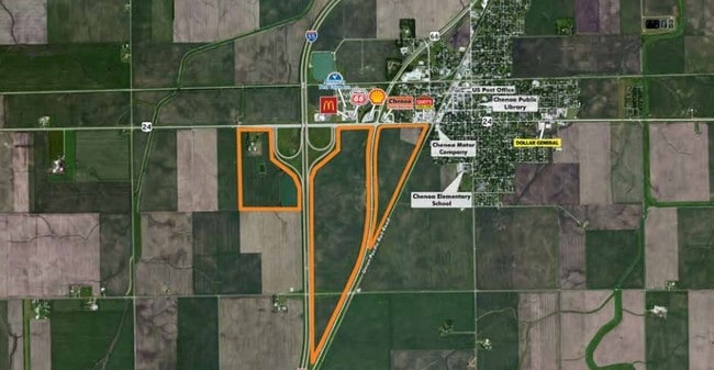
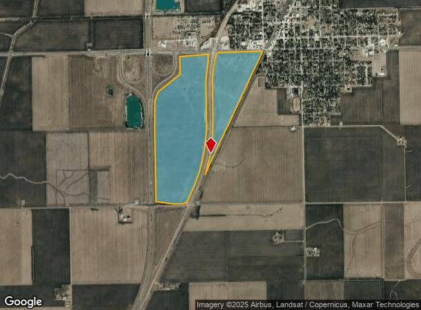
66 Rt 55 & Division St, Chenoa, IL 61726
NEARBY LISTINGS FOR SALE OR LEASE
-
-
View all Chenoa listings for sale on LoopNet.com
Property Detail
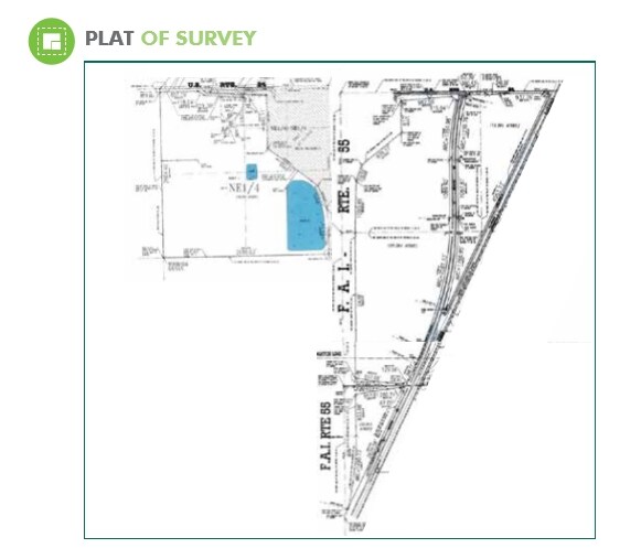
66 Rt 55 & Division St
03-11-400-006
SEC 11-26-4E ALL LYING W OF RR (EX HWY & 2.12 ACS RD PER 94-5990)
Farms
Mclean
X
Illinois
17113C0200E
242.54 AC
2022
Bloomington/Normal
2024
Other Market Areas
005700
Bloomington, IL
DEMOGRAPHICS near 66 Rt 55 & Division St
1 mile
3 mile
5 mile
2024 Total Population
893
1,862
2,309
2029 Population
893
1,871
2,312
Pop Growth 2024-2029
0.00%
+ 0.48%
+ 0.13%
Average Age
41
42
42
2024 Total Households
373
783
956
HH Growth 2024-2029
0.00%
+ 0.38%
0.00%
Median Household Inc
$72,655
$64,253
$72,060
Avg Household Size
2.40
2.40
2.40
2024 Avg HH Vehicles
2.00
2.00
2.00
Median Home Value
$136,549
$127,524
$140,151
Median Year Built
1961
1964
1964
Nearby Places
Map Layers
Map Styles
 Street
 Aerial
Transit
 Traffic
 Biking
Places
Listings with unknown addresses are not visible on the map
- Restaurants
- Banks
- Shops
- Fitness
- Groceries
PUBLIC TRANSPORTATION
AIRPORT
Central Il Regional/Bloomington-Normal
Drive
Walk
Distance
Central Il Regional/Bloomington-Normal
36 min
24.4 mi
Freight Ports
Port Milwaukee
Drive
Walk
Distance
Port Milwaukee
215 min
183.8 mi
SALE & LEASE HISTORY
LISTING DATE
SALE/LEASE

Jul 05, 2017
For Sale
Nearby Properties
Address
Land Use
TOTAL SIZE
Lot Size
Zoning
Address
Land Use
TOTAL SIZE
Lot Size
Zoning
167.03 AC
Address
Land Use
TOTAL SIZE
Lot Size
Zoning
88.76 AC
Address
Land Use
TOTAL SIZE
Lot Size
Zoning
Address
Land Use
TOTAL SIZE
Lot Size
Zoning
6,336 SF
3.73 AC
Address
Land Use
TOTAL SIZE
Lot Size
Zoning
3,825 SF
1.33 AC
Address
Land Use
TOTAL SIZE
Lot Size
Zoning
0.78 AC
Address
Land Use
TOTAL SIZE
Lot Size
Zoning
1.04 AC
Address
Land Use
TOTAL SIZE
Lot Size
Zoning
6,062 SF
120 AC
Address
Land Use
TOTAL SIZE
Lot Size
Zoning
0.38 AC
Address
Land Use
TOTAL SIZE
Lot Size
Zoning
19.49 AC
Address
Land Use
TOTAL SIZE
Lot Size
Zoning
0.42 AC
Address
Land Use
TOTAL SIZE
Lot Size
Zoning
5.33 AC
Address
Land Use
TOTAL SIZE
Lot Size
Zoning
4,693 SF
14.94 AC
Address
Land Use
TOTAL SIZE
Lot Size
Zoning
2,531 SF
11.27 AC
Address
Land Use
TOTAL SIZE
Lot Size
Zoning
6,428 SF
9.68 AC
Address
Land Use
TOTAL SIZE
Lot Size
Zoning
1,834 SF
160 AC
Address
Land Use
TOTAL SIZE
Lot Size
Zoning
7,560 SF
1.30 AC
Address
Land Use
TOTAL SIZE
Lot Size
Zoning
2,913 SF
40 AC
Address
Land Use
TOTAL SIZE
Lot Size
Zoning
1,344 SF
80 AC
Address
Land Use
TOTAL SIZE
Lot Size
Zoning
4,335 SF
4.23 AC
Address
Land Use
TOTAL SIZE
Lot Size
Zoning
1,492 SF
157.56 AC
Address
Land Use
TOTAL SIZE
Lot Size
Zoning
Address
Land Use
TOTAL SIZE
Lot Size
Zoning
0.56 AC
Address
Land Use
TOTAL SIZE
Lot Size
Zoning
2,205 SF
1.30 AC
Address
Land Use
TOTAL SIZE
Lot Size
Zoning
2,772 SF
7.79 AC
Address
Land Use
TOTAL SIZE
Lot Size
Zoning
1,426 SF
40 AC
Address
Land Use
TOTAL SIZE
Lot Size
Zoning
2,541 SF
0.57 AC
Address
Land Use
TOTAL SIZE
Lot Size
Zoning
6.18 AC
The World's #1 Commercial Real Estate Marketplace
Connect with us
© 2026 CoStar Group
The information above has been obtained from sources believed reliable. While we do not doubt its accuracy we have not verified it and make no guarantee, warranty or representation about it. It is your responsibility to independently confirm its accuracy and completeness. Any projections, opinions, assumptions, or estimates used are for example only and do not represent the current or future performance of the property. The value of this transaction to you depends on tax and other factors which should be evaluated by your tax, financial, and legal advisors. You and your advisors should conduct a careful, independent investigation of the property to determine to your satisfaction the suitability of the property for your needs.