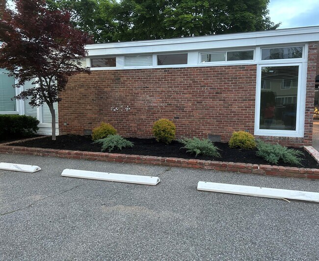
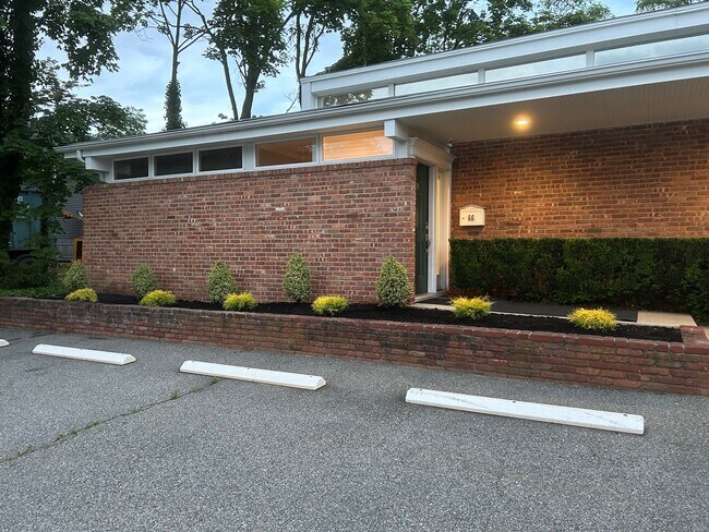
Property Record
66 Split Rock Rd, Syosset, NY 11791

Save to a Folder
{{folder.Name}}
{{folder.ListingIds.length}} Properties
{{folder.ListingIds.length}} Property
Create a New Folder
Property Detail
66 Split Rock Rd
Nassau County-Suffolk County, NY
TOWN #3 SCH DIST 012
2489-25-009-00-0025-0
Nassau
Hospitalpublic
New York
B and X Area of moderate flood hazard, usually the area between the limits of the 100-year and 500-year floods.
25
2025
0.21 AC
2026
Eastern Nassau
518300
Long Island (New York)
2,340 SF
NEARBY LISTINGS FOR SALE OR LEASE
DEMOGRAPHICS near 66 Split Rock Rd
1 mile
3 mile
5 mile
2025 Total Population
10,015
56,716
166,173
2030 Population
10,088
57,367
166,727
Pop Growth 2025-2030
+ 0.73%
+ 1.15%
+ 0.33%
Average Age
42
43
43
2025 Total Households
3,122
18,252
53,669
HH Growth 2025-2030
+ 0.54%
+ 1.12%
+ 0.29%
Median Household Inc
$196,112
$186,375
$167,665
Avg Household Size
3.10
3.00
2.90
2025 Avg HH Vehicles
2.00
2.00
2.00
Median Home Value
$953,512
$914,894
$821,305
Median Year Built
1962
1962
1958
Nearby Places
Map Layers
Map Styles
 Street
 Aerial
Layers
 Traffic
 Biking
Places
Listings with unknown addresses are not visible on the map
- Restaurants
- Banks
- Shops
- Fitness
- Groceries
PUBLIC TRANSPORTATION
COMMUTER RAIL
Syosset Station (Port Jefferson Branch - Long Island Rail Road)
Drive
Walk
Distance
Syosset Station (Port Jefferson Branch - Long Island Rail Road)
1 min
9 min
0.5 mi
Cold Spring Harbor Station (Port Jefferson Branch - Long Island Rail Road)
Drive
Walk
Distance
Cold Spring Harbor Station (Port Jefferson Branch - Long Island Rail Road)
8 min
3.3 mi
AIRPORT
LaGuardia
Drive
Walk
Distance
LaGuardia
37 min
24.0 mi
John F Kennedy International
Drive
Walk
Distance
John F Kennedy International
39 min
24.5 mi
Westchester County
Drive
Walk
Distance
Westchester County
67 min
44.4 mi
Freight Ports
NY - Red Hook Container Terminal
Drive
Walk
Distance
NY - Red Hook Container Terminal
48 min
32.1 mi
SALE & LEASE HISTORY
LISTING DATE
SALE/LEASE

Oct 11, 2024
For Sale
Nearby Properties
Address
Land Use
TOTAL SIZE
Lot Size
Zoning
Address
Land Use
TOTAL SIZE
Lot Size
Zoning
Address
Land Use
TOTAL SIZE
Lot Size
Zoning
Address
Land Use
TOTAL SIZE
Lot Size
Zoning
Address
Land Use
TOTAL SIZE
Lot Size
Zoning
441,456 SF
47.92 AC
Address
Land Use
TOTAL SIZE
Lot Size
Zoning
Address
Land Use
TOTAL SIZE
Lot Size
Zoning
178,486 SF
53.25 AC
Address
Land Use
TOTAL SIZE
Lot Size
Zoning
469,586 SF
53.14 AC
Address
Land Use
TOTAL SIZE
Lot Size
Zoning
800 SF
45.25 AC
Address
Land Use
TOTAL SIZE
Lot Size
Zoning
300,526 SF
44.30 AC
Address
Land Use
TOTAL SIZE
Lot Size
Zoning
75,253 SF
44.28 AC
Address
Land Use
TOTAL SIZE
Lot Size
Zoning
160 SF
241.23 AC
Address
Land Use
TOTAL SIZE
Lot Size
Zoning
Address
Land Use
TOTAL SIZE
Lot Size
Zoning
2,555 SF
284.67 AC
Address
Land Use
TOTAL SIZE
Lot Size
Zoning
Address
Land Use
TOTAL SIZE
Lot Size
Zoning
Address
Land Use
TOTAL SIZE
Lot Size
Zoning
534,840 SF
26.15 AC
Address
Land Use
TOTAL SIZE
Lot Size
Zoning
29,574 SF
174.23 AC
Address
Land Use
TOTAL SIZE
Lot Size
Zoning
146,287 SF
48.63 AC
Address
Land Use
TOTAL SIZE
Lot Size
Zoning
77,284 SF
40.86 AC
Address
Land Use
TOTAL SIZE
Lot Size
Zoning
159,471 SF
28.50 AC
Address
Land Use
TOTAL SIZE
Lot Size
Zoning
Address
Land Use
TOTAL SIZE
Lot Size
Zoning
220,367 SF
24 AC
Address
Land Use
TOTAL SIZE
Lot Size
Zoning
66,061 SF
18.79 AC
Address
Land Use
TOTAL SIZE
Lot Size
Zoning
546,788 SF
21.16 AC
Address
Land Use
TOTAL SIZE
Lot Size
Zoning
83.59 AC
Address
Land Use
TOTAL SIZE
Lot Size
Zoning
Address
Land Use
TOTAL SIZE
Lot Size
Zoning
28,537 SF
5.21 AC
Address
Land Use
TOTAL SIZE
Lot Size
Zoning
147,175 SF
10.28 AC
Address
Land Use
TOTAL SIZE
Lot Size
Zoning
204,726 SF
28.34 AC
Address
Land Use
TOTAL SIZE
Lot Size
Zoning
69,168 SF
15.12 AC
The World's #1 Commercial Real Estate Marketplace
Connect with us
© 2026 CoStar Group
The information above has been obtained from sources believed reliable. While we do not doubt its accuracy we have not verified it and make no guarantee, warranty or representation about it. It is your responsibility to independently confirm its accuracy and completeness. Any projections, opinions, assumptions, or estimates used are for example only and do not represent the current or future performance of the property. The value of this transaction to you depends on tax and other factors which should be evaluated by your tax, financial, and legal advisors. You and your advisors should conduct a careful, independent investigation of the property to determine to your satisfaction the suitability of the property for your needs.