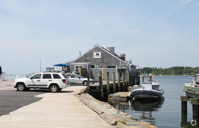
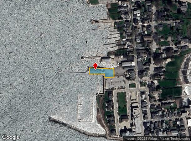
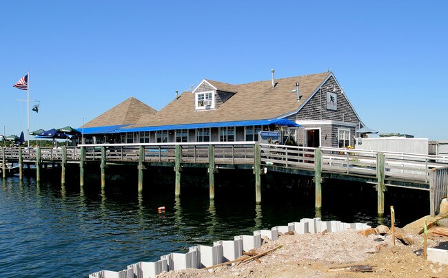
Property Record
66 Water St, Stonington, CT 06378
NEARBY LISTINGS FOR SALE OR LEASE
Property Detail
66 Water St
STON-000101-000001-000003B
New London
Commercialbuilding
Connecticut
VE
3b
09011C0533J
0.32 AC
2025
SE New London
2025
Hartford
705200
Norwich-New London, CT
3,388 SF
DEMOGRAPHICS near 66 Water St
1 Mile
3 Mile
5 Mile
2024 Total Population
1,558
5,465
28,383
2029 Population
1,587
5,553
28,850
Pop Growth 2024-2029
+ 1.86%
+ 1.61%
+ 1.65%
Average Age
52
51
49
2024 Total Households
837
2,604
12,869
HH Growth 2024-2029
+ 1.79%
+ 1.65%
+ 1.62%
Median Household Inc
$87,369
$101,793
$102,972
Avg Household Size
1.90
2.00
2.10
2024 Avg HH Vehicles
2.00
2.00
2.00
Median Home Value
$683,520
$572,468
$437,334
Median Year Built
1946
1953
1966
Nearby Places
- Restaurants
- Banks
- Shops
- Fitness
- Groceries
PUBLIC TRANSPORTATION
COMMUTER RAIL
Mystic Amtrak (Northeast Regional - Amtrak)
DRIVE
WALK
Distance
Mystic Amtrak (Northeast Regional - Amtrak)
9 min
4.6 mi
Westerly Amtrak Station (Northeast Regional - Amtrak)
DRIVE
WALK
Distance
Westerly Amtrak Station (Northeast Regional - Amtrak)
12 min
6.2 mi
Freight Ports
Port of Davisville, RI
DRIVE
WALK
Distance
Port of Davisville, RI
63 min
43.4 mi
Nearby Properties
Address
Land Use
TOTAL SIZE
Lot Size
Zoning
Address
Land Use
TOTAL SIZE
Lot Size
Zoning
74,328 SF
19.50 AC
RR-80
Address
Land Use
TOTAL SIZE
Lot Size
Zoning
40.80 AC
M-1
Address
Land Use
TOTAL SIZE
Lot Size
Zoning
85,073 SF
17.60 AC
RA-20
Address
Land Use
TOTAL SIZE
Lot Size
Zoning
1.30 AC
Address
Land Use
TOTAL SIZE
Lot Size
Zoning
25.88 AC
RR-80
Address
Land Use
TOTAL SIZE
Lot Size
Zoning
46,652 SF
12.23 AC
RC-120
Address
Land Use
TOTAL SIZE
Lot Size
Zoning
48.70 AC
GB-130
Address
Land Use
TOTAL SIZE
Lot Size
Zoning
3.50 AC
RC-120
Address
Land Use
TOTAL SIZE
Lot Size
Zoning
40,534 SF
20.84 AC
RC-120
Address
Land Use
TOTAL SIZE
Lot Size
Zoning
4.80 AC
RL
Address
Land Use
TOTAL SIZE
Lot Size
Zoning
7.62 AC
RM-20
Address
Land Use
TOTAL SIZE
Lot Size
Zoning
2,616 SF
3.21 AC
RR-80
Address
Land Use
TOTAL SIZE
Lot Size
Zoning
1.15 AC
MC-80
Address
Land Use
TOTAL SIZE
Lot Size
Zoning
12.40 AC
RM-20
Address
Land Use
TOTAL SIZE
Lot Size
Zoning
3 AC
RR-80
Address
Land Use
TOTAL SIZE
Lot Size
Zoning
21.96 AC
TC-80
Address
Land Use
TOTAL SIZE
Lot Size
Zoning
22,538 SF
3.26 AC
GC-60
Address
Land Use
TOTAL SIZE
Lot Size
Zoning
17,925 SF
5.38 AC
LS-5
Address
Land Use
TOTAL SIZE
Lot Size
Zoning
2.30 AC
RR-80
Address
Land Use
TOTAL SIZE
Lot Size
Zoning
3.60 AC
RR-80
Address
Land Use
TOTAL SIZE
Lot Size
Zoning
8.50 AC
LI-130
Address
Land Use
TOTAL SIZE
Lot Size
Zoning
9,344 SF
0.37 AC
R-1
Address
Land Use
TOTAL SIZE
Lot Size
Zoning
11.74 AC
M-1
Address
Land Use
TOTAL SIZE
Lot Size
Zoning
3,744 SF
2.30 AC
MC-80
Address
Land Use
TOTAL SIZE
Lot Size
Zoning
10.20 AC
GC-60
Address
Land Use
TOTAL SIZE
Lot Size
Zoning
8.03 AC
GC-60
Address
Land Use
TOTAL SIZE
Lot Size
Zoning
10.20 AC
RC-120
Address
Land Use
TOTAL SIZE
Lot Size
Zoning
4.30 AC
MC-80
Address
Land Use
TOTAL SIZE
Lot Size
Zoning
580 SF
0.26 AC
RC-120
Address
Land Use
TOTAL SIZE
Lot Size
Zoning
3.32 AC
RM-20
The World's #1 Commercial Real Estate Marketplace
Connect with us
© 2025 CoStar Group
The information above has been obtained from sources believed reliable. While we do not doubt its accuracy we have not verified it and make no guarantee, warranty or representation about it. It is your responsibility to independently confirm its accuracy and completeness. Any projections, opinions, assumptions, or estimates used are for example only and do not represent the current or future performance of the property. The value of this transaction to you depends on tax and other factors which should be evaluated by your tax, financial, and legal advisors. You and your advisors should conduct a careful, independent investigation of the property to determine to your satisfaction the suitability of the property for your needs.