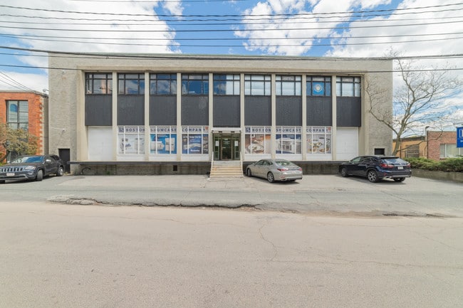
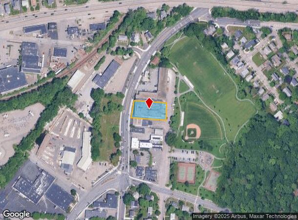
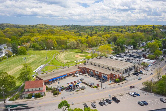
Property Record
66 Winchester St, Newton Highlands, MA 02461
NEARBY LISTINGS FOR SALE OR LEASE
Property Detail
66 Winchester St
NEWT-000083-000003-000046
Middlesex
Storebuilding
Massachusetts
X
46
25017C0554F
0.46 AC
2025
Newton/Dover
2025
Boston
374100
Boston-Cambridge-Newton, MA-NH
31,878 SF
DEMOGRAPHICS near 66 Winchester St
1 Mile
3 Mile
5 Mile
2024 Total Population
16,384
117,751
416,439
2029 Population
16,165
116,343
406,829
Pop Growth 2024-2029
(1.34%)
(1.20%)
(2.31%)
Average Age
43
41
40
2024 Total Households
6,135
42,039
166,796
HH Growth 2024-2029
(1.42%)
(1.33%)
(2.63%)
Median Household Inc
$178,373
$175,321
$119,777
Avg Household Size
2.60
2.60
2.30
2024 Avg HH Vehicles
2.00
2.00
1.00
Median Home Value
$1,051,361
$1,043,857
$895,489
Median Year Built
1948
1949
1949
Nearby Places
Map Layers
Map Styles
 Street
 Aerial
- Restaurants
- Banks
- Shops
- Fitness
- Groceries
PUBLIC TRANSPORTATION
TRANSIT/SUBWAY
Newton Highlands Station (Green Line - D - Massachusetts Bay Transportation Authority Subway (The T))
DRIVE
WALK
Distance
Newton Highlands Station (Green Line - D - Massachusetts Bay Transportation Authority Subway (The T))
1 min
9 min
0.5 mi
COMMUTER RAIL
Needham Heights (Needham Line - Massachusetts Bay Transportation Authority Commuter Rail (Purple Line))
DRIVE
WALK
Distance
Needham Heights (Needham Line - Massachusetts Bay Transportation Authority Commuter Rail (Purple Line))
5 min
2.4 mi
Newtonville (Framingham/Worcester Line - Massachusetts Bay Transportation Authority Commuter Rail (Purple Line))
DRIVE
WALK
Distance
Newtonville (Framingham/Worcester Line - Massachusetts Bay Transportation Authority Commuter Rail (Purple Line))
9 min
4.6 mi
AIRPORT
General Edward Lawrence Logan International
DRIVE
WALK
Distance
General Edward Lawrence Logan International
24 min
13.8 mi
Freight Ports
Port of Boston
DRIVE
WALK
Distance
Port of Boston
23 min
12.1 mi
SALE & LEASE HISTORY
LISTING DATE
SALE/LEASE

Jun 04, 2019
For Lease
Nearby Properties
Address
Land Use
TOTAL SIZE
Lot Size
Zoning
Address
Land Use
TOTAL SIZE
Lot Size
Zoning
30,845 SF
50.36 AC
SR1
Address
Land Use
TOTAL SIZE
Lot Size
Zoning
387,550 SF
7.99 AC
MU1
Address
Land Use
TOTAL SIZE
Lot Size
Zoning
412,208 SF
7.93 AC
I
Address
Land Use
TOTAL SIZE
Lot Size
Zoning
30,170 SF
19 AC
SR2
Address
Land Use
TOTAL SIZE
Lot Size
Zoning
228,483 SF
7.57 AC
BU1
Address
Land Use
TOTAL SIZE
Lot Size
Zoning
317,049 SF
11.22 AC
M05
Address
Land Use
TOTAL SIZE
Lot Size
Zoning
1,050 SF
8.77 AC
BU4
Address
Land Use
TOTAL SIZE
Lot Size
Zoning
4.74 AC
NEBC
Address
Land Use
TOTAL SIZE
Lot Size
Zoning
179,834 SF
8.57 AC
PUB
Address
Land Use
TOTAL SIZE
Lot Size
Zoning
241,737 SF
4.67 AC
BU1
Address
Land Use
TOTAL SIZE
Lot Size
Zoning
25,744 SF
35.80 AC
S40
Address
Land Use
TOTAL SIZE
Lot Size
Zoning
76,800 SF
22.65 AC
MU1
Address
Land Use
TOTAL SIZE
Lot Size
Zoning
5,119 SF
119.98 AC
S15
Address
Land Use
TOTAL SIZE
Lot Size
Zoning
286,928 SF
2.89 AC
BU1
Address
Land Use
TOTAL SIZE
Lot Size
Zoning
151,232 SF
8.27 AC
PUB
Address
Land Use
TOTAL SIZE
Lot Size
Zoning
220,500 SF
1.96 AC
NEBC
Address
Land Use
TOTAL SIZE
Lot Size
Zoning
208,500 SF
13.98 AC
I
Address
Land Use
TOTAL SIZE
Lot Size
Zoning
200,730 SF
5.95 AC
BU4
Address
Land Use
TOTAL SIZE
Lot Size
Zoning
59.94 AC
PUB
Address
Land Use
TOTAL SIZE
Lot Size
Zoning
Address
Land Use
TOTAL SIZE
Lot Size
Zoning
Address
Land Use
TOTAL SIZE
Lot Size
Zoning
7,873 SF
5.04 AC
SR1
Address
Land Use
TOTAL SIZE
Lot Size
Zoning
144,584 SF
4.86 AC
PUB
Address
Land Use
TOTAL SIZE
Lot Size
Zoning
264,014 SF
10.64 AC
NEBC
Address
Land Use
TOTAL SIZE
Lot Size
Zoning
24.20 AC
S25
Address
Land Use
TOTAL SIZE
Lot Size
Zoning
14.64 AC
S15
Address
Land Use
TOTAL SIZE
Lot Size
Zoning
332,100 SF
4.63 AC
M05
Address
Land Use
TOTAL SIZE
Lot Size
Zoning
30,027 SF
96.45 AC
ORD
Address
Land Use
TOTAL SIZE
Lot Size
Zoning
170,966 SF
2.84 AC
MU4
Address
Land Use
TOTAL SIZE
Lot Size
Zoning
80,447 SF
6.52 AC
PUB
The World's #1 Commercial Real Estate Marketplace
Connect with us
© 2025 CoStar Group
The information above has been obtained from sources believed reliable. While we do not doubt its accuracy we have not verified it and make no guarantee, warranty or representation about it. It is your responsibility to independently confirm its accuracy and completeness. Any projections, opinions, assumptions, or estimates used are for example only and do not represent the current or future performance of the property. The value of this transaction to you depends on tax and other factors which should be evaluated by your tax, financial, and legal advisors. You and your advisors should conduct a careful, independent investigation of the property to determine to your satisfaction the suitability of the property for your needs.