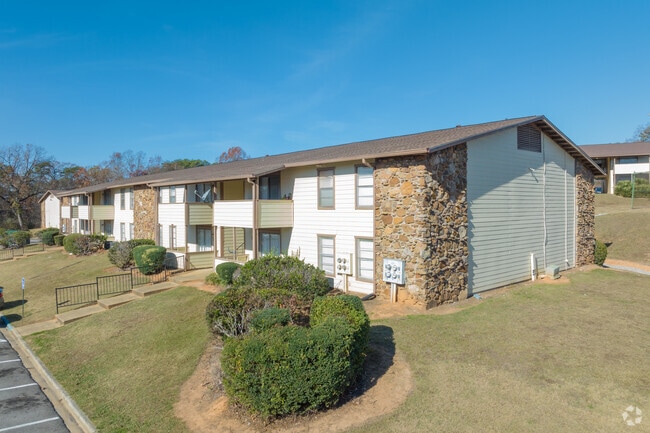
Property Record
660 9Th Ave Sw, Bessemer, AL 35022


NEARBY LISTINGS FOR SALE OR LEASE
-
-
View all Bessemer listings for sale on LoopNet.com
Property Detail
660 9Th Ave Sw
38-00-17-2-007-022.000
POB 460 FT NE OF INTER OF NW R/W US HWY 11 & S/L OF NW1/4 SEC 17 TWP 19 R 4 TH NE 80 FT TH W 156 FT TH N 300 FT TH TH W 880 FT TH S 702 FT TO PT ON NE BDRY OF STATE R/W TH SE 220 FT TH E 270 FT TH NE 460 FT TH E 270 FT TO POB
Apartment
Jefferson
X
Alabama
01073C0538H
15.03 AC
2023
Outer Bessemer/Fairfield
2024
Birmingham
014104
Birmingham, AL
191,517 SF
DEMOGRAPHICS near 660 9Th Ave Sw
1 Mile
3 Mile
5 Mile
2024 Total Population
3,292
27,197
55,166
2029 Population
3,200
26,837
54,318
Pop Growth 2024-2029
(2.79%)
(1.32%)
(1.54%)
Average Age
40
40
40
2024 Total Households
1,356
10,856
22,085
HH Growth 2024-2029
(2.88%)
(1.46%)
(1.68%)
Median Household Inc
$32,840
$39,270
$45,880
Avg Household Size
2.40
2.40
2.40
2024 Avg HH Vehicles
2.00
2.00
2.00
Median Home Value
$155,752
$128,282
$147,193
Median Year Built
1966
1965
1969
Nearby Places
Map Layers
Map Styles
 Street
 Aerial
- Restaurants
- Banks
- Shops
- Fitness
- Groceries
PUBLIC TRANSPORTATION
AIRPORT
Birmingham-Shuttlesworth International
DRIVE
WALK
Distance
Birmingham-Shuttlesworth International
27 min
21.8 mi
Freight Ports
Port of Mobile
DRIVE
WALK
Distance
Port of Mobile
279 min
236.9 mi
Nearby Properties
Address
Land Use
TOTAL SIZE
Lot Size
Zoning
Address
Land Use
TOTAL SIZE
Lot Size
Zoning
857,420 SF
34.50 AC
I3
Address
Land Use
TOTAL SIZE
Lot Size
Zoning
106 AC
I3
Address
Land Use
TOTAL SIZE
Lot Size
Zoning
184,428 SF
9.70 AC
01
Address
Land Use
TOTAL SIZE
Lot Size
Zoning
311,900 SF
30.20 AC
Address
Land Use
TOTAL SIZE
Lot Size
Zoning
210,815 SF
114 AC
I1-A
Address
Land Use
TOTAL SIZE
Lot Size
Zoning
47,705 SF
0.69 AC
01
Address
Land Use
TOTAL SIZE
Lot Size
Zoning
553,137 SF
87 AC
I2
Address
Land Use
TOTAL SIZE
Lot Size
Zoning
200,227 SF
25.10 AC
C-4
Address
Land Use
TOTAL SIZE
Lot Size
Zoning
175,224 SF
9.70 AC
R2
Address
Land Use
TOTAL SIZE
Lot Size
Zoning
38,868 SF
10.90 AC
C-4
Address
Land Use
TOTAL SIZE
Lot Size
Zoning
136,115 SF
14.90 AC
C3
Address
Land Use
TOTAL SIZE
Lot Size
Zoning
100,050 SF
14 AC
C-4
Address
Land Use
TOTAL SIZE
Lot Size
Zoning
122,720 SF
6.77 AC
O1-R
Address
Land Use
TOTAL SIZE
Lot Size
Zoning
137,641 SF
26.80 AC
R4
Address
Land Use
TOTAL SIZE
Lot Size
Zoning
132,116 SF
9.15 AC
R3
Address
Land Use
TOTAL SIZE
Lot Size
Zoning
132,683 SF
16 AC
R-4
Address
Land Use
TOTAL SIZE
Lot Size
Zoning
63.30 AC
I3
Address
Land Use
TOTAL SIZE
Lot Size
Zoning
1,090,237 SF
28.10 AC
I4
Address
Land Use
TOTAL SIZE
Lot Size
Zoning
2.50 AC
C4
Address
Land Use
TOTAL SIZE
Lot Size
Zoning
66,900 SF
3.78 AC
I4
Address
Land Use
TOTAL SIZE
Lot Size
Zoning
25,182 SF
1.76 AC
C4
Address
Land Use
TOTAL SIZE
Lot Size
Zoning
38,376 SF
4.87 AC
C3
Address
Land Use
TOTAL SIZE
Lot Size
Zoning
47,284 SF
11.30 AC
0-1/
Address
Land Use
TOTAL SIZE
Lot Size
Zoning
23,264 SF
4.06 AC
C4
Address
Land Use
TOTAL SIZE
Lot Size
Zoning
45,959 SF
6.72 AC
C-4
Address
Land Use
TOTAL SIZE
Lot Size
Zoning
366,421 SF
21 AC
I3
Address
Land Use
TOTAL SIZE
Lot Size
Zoning
27,383 SF
7 AC
C4
Address
Land Use
TOTAL SIZE
Lot Size
Zoning
3.29 AC
O1
Address
Land Use
TOTAL SIZE
Lot Size
Zoning
81,846 SF
77.30 AC
I3
The World's #1 Commercial Real Estate Marketplace
Connect with us
© 2026 CoStar Group
The information above has been obtained from sources believed reliable. While we do not doubt its accuracy we have not verified it and make no guarantee, warranty or representation about it. It is your responsibility to independently confirm its accuracy and completeness. Any projections, opinions, assumptions, or estimates used are for example only and do not represent the current or future performance of the property. The value of this transaction to you depends on tax and other factors which should be evaluated by your tax, financial, and legal advisors. You and your advisors should conduct a careful, independent investigation of the property to determine to your satisfaction the suitability of the property for your needs.