Property Record
660 Ada Dr Se, Ada, MI 49301
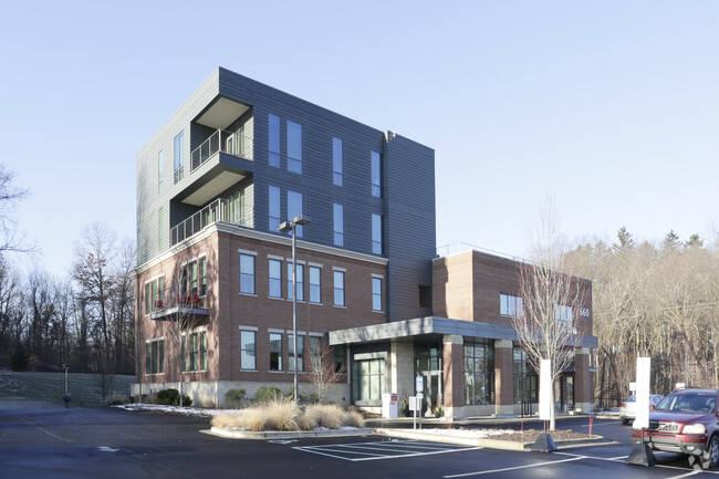

Property Detail
660 Ada Dr Se
Grand Rapids-Wyoming-Kentwood, MI
411534156006 PART OF NE 1/4 OF SEC 33 & COM AT WLY COR OF LOT 2 BLOCK 12 AMENDED PLAT OF LOTS 1 THRU 30, BLK 7 & LOTS 1 THRU
41-15-34-156-005
KENT
Commercialnec
Michigan
2024
2.82 AC
2025
Ada/Lowell
011902
West Michigan
NEARBY LISTINGS FOR SALE OR LEASE
DEMOGRAPHICS near 660 Ada Dr Se
1 mile
3 mile
5 mile
2025 Total Population
2,455
20,900
54,702
2030 Population
2,559
21,604
56,323
Pop Growth 2025-2030
+ 4.24%
+ 3.37%
+ 2.96%
Average Age
40
41
41
2025 Total Households
823
7,277
19,759
HH Growth 2025-2030
+ 4.37%
+ 3.44%
+ 3.07%
Median Household Inc
$184,803
$152,307
$120,312
Avg Household Size
2.90
2.90
2.60
2025 Avg HH Vehicles
2.00
2.00
2.00
Median Home Value
$452,068
$492,065
$460,174
Median Year Built
1989
1991
1987
Nearby Places
Map Layers
Map Styles
 Street
 Aerial
Layers
 Traffic
 Biking
Places
Listings with unknown addresses are not visible on the map
- Restaurants
- Banks
- Shops
- Fitness
- Groceries
PUBLIC TRANSPORTATION
AIRPORT
Gerald R Ford International
Drive
Walk
Distance
Gerald R Ford International
23 min
11.0 mi
SALE & LEASE HISTORY
LISTING DATE
SALE/LEASE

Jun 06, 2018
For Lease
Nearby Properties
Address
Land Use
TOTAL SIZE
Lot Size
Zoning
Address
Land Use
TOTAL SIZE
Lot Size
Zoning
277.36 AC
I
Address
Land Use
TOTAL SIZE
Lot Size
Zoning
709,488 SF
106.95 AC
LI
Address
Land Use
TOTAL SIZE
Lot Size
Zoning
Address
Land Use
TOTAL SIZE
Lot Size
Zoning
226,877 SF
22.40 AC
R2
Address
Land Use
TOTAL SIZE
Lot Size
Zoning
8.97 AC
Address
Land Use
TOTAL SIZE
Lot Size
Zoning
Address
Land Use
TOTAL SIZE
Lot Size
Zoning
Address
Land Use
TOTAL SIZE
Lot Size
Zoning
33,540 SF
5.67 AC
PO
Address
Land Use
TOTAL SIZE
Lot Size
Zoning
14,700 SF
1.44 AC
Address
Land Use
TOTAL SIZE
Lot Size
Zoning
0.65 AC
Address
Land Use
TOTAL SIZE
Lot Size
Zoning
77,995 SF
8.74 AC
B2
Address
Land Use
TOTAL SIZE
Lot Size
Zoning
Address
Land Use
TOTAL SIZE
Lot Size
Zoning
64,790 SF
290,921.90 AC
PUD
Address
Land Use
TOTAL SIZE
Lot Size
Zoning
29,224 SF
5.48 AC
I
Address
Land Use
TOTAL SIZE
Lot Size
Zoning
0.20 AC
Address
Land Use
TOTAL SIZE
Lot Size
Zoning
44,215 SF
12.51 AC
PUD
Address
Land Use
TOTAL SIZE
Lot Size
Zoning
4,600 SF
0.64 AC
Address
Land Use
TOTAL SIZE
Lot Size
Zoning
39,312 SF
7.01 AC
R2
Address
Land Use
TOTAL SIZE
Lot Size
Zoning
79,921 SF
420,750 AC
PUD
Address
Land Use
TOTAL SIZE
Lot Size
Zoning
0.92 AC
C1
Address
Land Use
TOTAL SIZE
Lot Size
Zoning
18,096 SF
2.53 AC
PO
Address
Land Use
TOTAL SIZE
Lot Size
Zoning
87,210 SF
4 AC
I
Address
Land Use
TOTAL SIZE
Lot Size
Zoning
34,276 SF
6.40 AC
PO
Address
Land Use
TOTAL SIZE
Lot Size
Zoning
9,414 SF
1.64 AC
Address
Land Use
TOTAL SIZE
Lot Size
Zoning
22,848 SF
0.28 AC
Address
Land Use
TOTAL SIZE
Lot Size
Zoning
32,588 SF
3.68 AC
PUD
Address
Land Use
TOTAL SIZE
Lot Size
Zoning
Address
Land Use
TOTAL SIZE
Lot Size
Zoning
14,026 SF
2.57 AC
R3
Address
Land Use
TOTAL SIZE
Lot Size
Zoning
19,610 SF
R1
Address
Land Use
TOTAL SIZE
Lot Size
Zoning
0.44 AC
The World's #1 Commercial Real Estate Marketplace
Connect with us
© 2026 CoStar Group
The information above has been obtained from sources believed reliable. While we do not doubt its accuracy we have not verified it and make no guarantee, warranty or representation about it. It is your responsibility to independently confirm its accuracy and completeness. Any projections, opinions, assumptions, or estimates used are for example only and do not represent the current or future performance of the property. The value of this transaction to you depends on tax and other factors which should be evaluated by your tax, financial, and legal advisors. You and your advisors should conduct a careful, independent investigation of the property to determine to your satisfaction the suitability of the property for your needs.