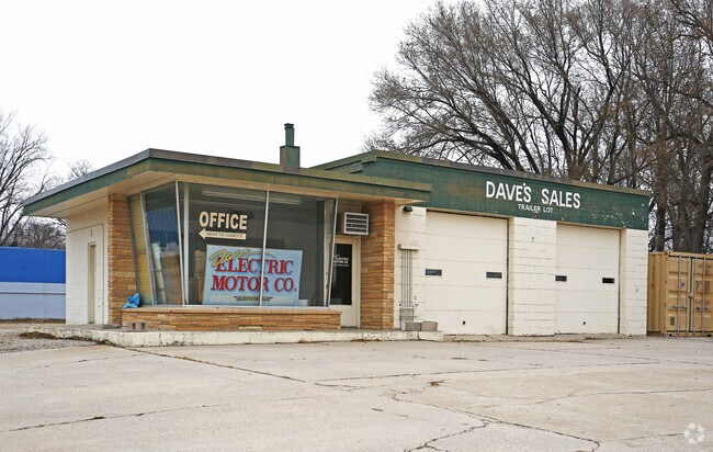
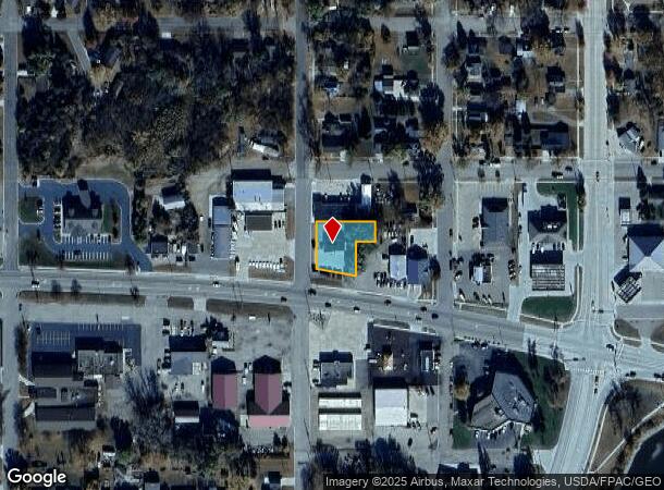
Property Record
660 Highway 212 W, Granite Falls, MN 56241

NEARBY LISTINGS FOR SALE OR LEASE
-
-
View all Granite Falls listings for sale on LoopNet.com
Property Detail
660 Highway 212 W
34-400-3908
Pillsbury's 2Nd Addition
Commercialnec
W 100 FT LOTS 8 & 9 & ALL LOT 10 BLK 39
X
Yellow Medicine
27173C0241D
Minnesota
2025
8,9
2025
0.35 AC
970100
Other Market Areas
DEMOGRAPHICS near 660 Highway 212 W
1 Mile
3 Mile
5 Mile
2024 Total Population
2,548
3,436
3,836
2029 Population
2,563
3,428
3,813
Pop Growth 2024-2029
+ 0.59%
(0.23%)
(0.60%)
Average Age
43
43
43
2024 Total Households
1,162
1,523
1,687
HH Growth 2024-2029
+ 0.52%
(0.26%)
(0.65%)
Median Household Inc
$57,839
$58,796
$59,720
Avg Household Size
2.10
2.20
2.20
2024 Avg HH Vehicles
2.00
2.00
2.00
Median Home Value
$155,727
$164,705
$166,319
Median Year Built
1968
1969
1969
Nearby Places
Map Layers
Map Styles
 Street
 Aerial
- Restaurants
- Banks
- Shops
- Fitness
- Groceries
SALE & LEASE HISTORY
LISTING DATE
SALE/LEASE

Nov 30, 2017
For Sale
Nearby Properties
Address
Land Use
TOTAL SIZE
Lot Size
Zoning
Address
Land Use
TOTAL SIZE
Lot Size
Zoning
28.70 AC
Address
Land Use
TOTAL SIZE
Lot Size
Zoning
13.43 AC
Address
Land Use
TOTAL SIZE
Lot Size
Zoning
150.60 AC
Address
Land Use
TOTAL SIZE
Lot Size
Zoning
Address
Land Use
TOTAL SIZE
Lot Size
Zoning
0.88 AC
Address
Land Use
TOTAL SIZE
Lot Size
Zoning
Address
Land Use
TOTAL SIZE
Lot Size
Zoning
11,804 SF
5.09 AC
Address
Land Use
TOTAL SIZE
Lot Size
Zoning
Address
Land Use
TOTAL SIZE
Lot Size
Zoning
Address
Land Use
TOTAL SIZE
Lot Size
Zoning
Address
Land Use
TOTAL SIZE
Lot Size
Zoning
159.90 AC
Address
Land Use
TOTAL SIZE
Lot Size
Zoning
Address
Land Use
TOTAL SIZE
Lot Size
Zoning
26,400 SF
10.73 AC
Address
Land Use
TOTAL SIZE
Lot Size
Zoning
5,698 SF
1.85 AC
Address
Land Use
TOTAL SIZE
Lot Size
Zoning
7,884 SF
1.26 AC
Address
Land Use
TOTAL SIZE
Lot Size
Zoning
Address
Land Use
TOTAL SIZE
Lot Size
Zoning
7,025 SF
0.28 AC
Address
Land Use
TOTAL SIZE
Lot Size
Zoning
1.22 AC
Address
Land Use
TOTAL SIZE
Lot Size
Zoning
78.99 AC
Address
Land Use
TOTAL SIZE
Lot Size
Zoning
Address
Land Use
TOTAL SIZE
Lot Size
Zoning
17,470 SF
0.47 AC
Address
Land Use
TOTAL SIZE
Lot Size
Zoning
7,791 SF
0.48 AC
Address
Land Use
TOTAL SIZE
Lot Size
Zoning
11,260 SF
6.33 AC
Address
Land Use
TOTAL SIZE
Lot Size
Zoning
4,954 SF
0.43 AC
Address
Land Use
TOTAL SIZE
Lot Size
Zoning
74.97 AC
Address
Land Use
TOTAL SIZE
Lot Size
Zoning
5,088 SF
0.26 AC
Address
Land Use
TOTAL SIZE
Lot Size
Zoning
Address
Land Use
TOTAL SIZE
Lot Size
Zoning
82.61 AC
Address
Land Use
TOTAL SIZE
Lot Size
Zoning
0.75 AC
Address
Land Use
TOTAL SIZE
Lot Size
Zoning
82.50 AC
The World's #1 Commercial Real Estate Marketplace
Connect with us
© 2025 CoStar Group
The information above has been obtained from sources believed reliable. While we do not doubt its accuracy we have not verified it and make no guarantee, warranty or representation about it. It is your responsibility to independently confirm its accuracy and completeness. Any projections, opinions, assumptions, or estimates used are for example only and do not represent the current or future performance of the property. The value of this transaction to you depends on tax and other factors which should be evaluated by your tax, financial, and legal advisors. You and your advisors should conduct a careful, independent investigation of the property to determine to your satisfaction the suitability of the property for your needs.