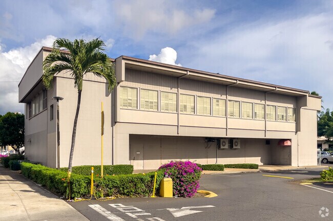
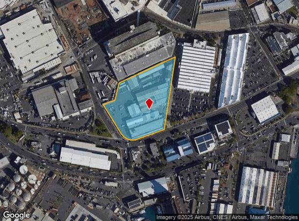
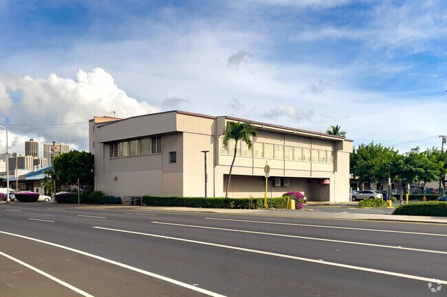
Property Record
660 N Nimitz Hwy, Honolulu, HI 96817
NEARBY LISTINGS FOR SALE OR LEASE
Property Detail
660 N Nimitz Hwy
1-1-5-010-007-0000
Retail Shed W/Mezz
Industrialgeneral
Honolulu
X
Hawaii
15003C0353G
4.44 AC
2024
Kalihi
2025
Hawaii
005700
Urban Honolulu, HI
92,610 SF
DEMOGRAPHICS near 660 N Nimitz Hwy
1 Mile
3 Mile
5 Mile
2024 Total Population
33,768
205,404
349,380
2029 Population
33,641
202,415
344,673
Pop Growth 2024-2029
(0.38%)
(1.46%)
(1.35%)
Average Age
44
44
43
2024 Total Households
13,312
82,578
138,609
HH Growth 2024-2029
(0.40%)
(1.33%)
(1.23%)
Median Household Inc
$56,436
$71,496
$74,049
Avg Household Size
2.30
2.30
2.30
2024 Avg HH Vehicles
1.00
1.00
1.00
Median Home Value
$479,829
$715,732
$743,151
Median Year Built
1977
1974
1973
Nearby Places
Map Layers
Map Styles
 Street
 Aerial
- Restaurants
- Banks
- Shops
- Fitness
- Groceries
PUBLIC TRANSPORTATION
AIRPORT
Daniel K Inouye International
DRIVE
WALK
Distance
Daniel K Inouye International
11 min
4.5 mi
Freight Ports
Honolulu Harbor, Oahu
DRIVE
WALK
Distance
Honolulu Harbor, Oahu
11 min
4.0 mi
Nearby Properties
Address
Land Use
TOTAL SIZE
Lot Size
Zoning
Address
Land Use
TOTAL SIZE
Lot Size
Zoning
7,944,732 SF
34.93 AC
BMX-3
Address
Land Use
TOTAL SIZE
Lot Size
Zoning
119.90 AC
U/X7/60
Address
Land Use
TOTAL SIZE
Lot Size
Zoning
1,675.63 AC
C/61/60
Address
Land Use
TOTAL SIZE
Lot Size
Zoning
13,088 SF
75.21 AC
P-2
Address
Land Use
TOTAL SIZE
Lot Size
Zoning
1,100,000 SF
9.65 AC
BMX-3
Address
Land Use
TOTAL SIZE
Lot Size
Zoning
55.93 AC
WI
Address
Land Use
TOTAL SIZE
Lot Size
Zoning
1,153,381 SF
425.42 AC
R-5
Address
Land Use
TOTAL SIZE
Lot Size
Zoning
45.65 AC
Kak
Address
Land Use
TOTAL SIZE
Lot Size
Zoning
42.67 AC
P-2
Address
Land Use
TOTAL SIZE
Lot Size
Zoning
1,599,500 SF
7.27 AC
BMX-3
Address
Land Use
TOTAL SIZE
Lot Size
Zoning
2.32 AC
Kak
Address
Land Use
TOTAL SIZE
Lot Size
Zoning
254,832 SF
2.92 AC
BMX-4
Address
Land Use
TOTAL SIZE
Lot Size
Zoning
104,386 SF
1.04 AC
ResMix
Address
Land Use
TOTAL SIZE
Lot Size
Zoning
172,305 SF
2.54 AC
ResMix
Address
Land Use
TOTAL SIZE
Lot Size
Zoning
12,430 SF
86.69 AC
P-1
Address
Land Use
TOTAL SIZE
Lot Size
Zoning
9,272 SF
141.38 AC
P-2
Address
Land Use
TOTAL SIZE
Lot Size
Zoning
273,214 SF
1.64 AC
ResMix
Address
Land Use
TOTAL SIZE
Lot Size
Zoning
446,464 SF
9.90 AC
Kak
Address
Land Use
TOTAL SIZE
Lot Size
Zoning
919,972 SF
14.45 AC
I-2
Address
Land Use
TOTAL SIZE
Lot Size
Zoning
66,180 SF
1.61 AC
ResMix
Address
Land Use
TOTAL SIZE
Lot Size
Zoning
14.38 AC
Kak
Address
Land Use
TOTAL SIZE
Lot Size
Zoning
936,400 SF
6.88 AC
Kak
Address
Land Use
TOTAL SIZE
Lot Size
Zoning
2.88 AC
ResMix
Address
Land Use
TOTAL SIZE
Lot Size
Zoning
386,846 SF
8.76 AC
A-1
Address
Land Use
TOTAL SIZE
Lot Size
Zoning
960 SF
71.97 AC
P-2
Address
Land Use
TOTAL SIZE
Lot Size
Zoning
468,275 SF
10.47 AC
BMX-3
Address
Land Use
TOTAL SIZE
Lot Size
Zoning
158,215 SF
1.83 AC
BMX-4
Address
Land Use
TOTAL SIZE
Lot Size
Zoning
204,596 SF
0.12 AC
BMX-4
Address
Land Use
TOTAL SIZE
Lot Size
Zoning
253,254 SF
10.73 AC
Kak
The World's #1 Commercial Real Estate Marketplace
Connect with us
© 2026 CoStar Group
The information above has been obtained from sources believed reliable. While we do not doubt its accuracy we have not verified it and make no guarantee, warranty or representation about it. It is your responsibility to independently confirm its accuracy and completeness. Any projections, opinions, assumptions, or estimates used are for example only and do not represent the current or future performance of the property. The value of this transaction to you depends on tax and other factors which should be evaluated by your tax, financial, and legal advisors. You and your advisors should conduct a careful, independent investigation of the property to determine to your satisfaction the suitability of the property for your needs.