Property Record
660 Ne Ocean Blvd, Stuart, FL 34996
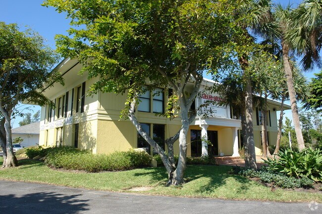

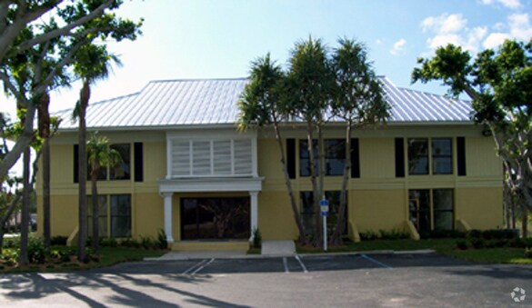
Property Detail
660 Ne Ocean Blvd
31-37-42-008-000-00010-0
LOT 1 MARRIOTT RESORT I (AT) INDIAN RIVER PLANTATION A PUD (PB 14 PG 72)BEING PORTION OF PARCEL IV PER OR 1759/1575
Officebuilding
MARTIN
PUDR
Florida
AE The base floodplain where base flood elevations are provided. AE Zones are now used on new format FIRMs instead of A1-A30 Zones.
1
2024
0.87 AC
2025
St Lucie Coastal
000100
Port St Lucie/Fort Pierce
7,296 SF
Port St. Lucie, FL
NEARBY LISTINGS FOR SALE OR LEASE
DEMOGRAPHICS near 660 Ne Ocean Blvd
1 mile
3 mile
5 mile
2024 Total Population
2,273
13,900
56,016
2029 Population
2,570
15,020
59,866
Pop Growth 2024-2029
+ 13.07%
+ 8.06%
+ 6.87%
Average Age
67
59
52
2024 Total Households
1,241
7,429
26,449
HH Growth 2024-2029
+ 12.89%
+ 7.98%
+ 7.27%
Median Household Inc
$116,977
$79,109
$65,048
Avg Household Size
1.80
1.80
2.00
2024 Avg HH Vehicles
1.00
2.00
2.00
Median Home Value
$897,119
$486,740
$422,613
Median Year Built
1985
1979
1982
Nearby Places
Map Layers
Map Styles
 Street
 Aerial
Transit
 Traffic
 Biking
Places
Listings with unknown addresses are not visible on the map
- Restaurants
- Banks
- Shops
- Fitness
- Groceries
Nearby Properties
Address
Land Use
TOTAL SIZE
Lot Size
Zoning
Address
Land Use
TOTAL SIZE
Lot Size
Zoning
152,866 SF
3.24 AC
HB1AA
Address
Land Use
TOTAL SIZE
Lot Size
Zoning
189,035 SF
20.63 AC
R3
Address
Land Use
TOTAL SIZE
Lot Size
Zoning
8,767 SF
26.59 AC
PS
Address
Land Use
TOTAL SIZE
Lot Size
Zoning
116,258 SF
14.58 AC
R3
Address
Land Use
TOTAL SIZE
Lot Size
Zoning
174,712 SF
6.31 AC
PUDR
Address
Land Use
TOTAL SIZE
Lot Size
Zoning
120,234 SF
4.83 AC
R3
Address
Land Use
TOTAL SIZE
Lot Size
Zoning
77,236 SF
9.11 AC
B1
Address
Land Use
TOTAL SIZE
Lot Size
Zoning
17,904 SF
306.72 AC
PS
Address
Land Use
TOTAL SIZE
Lot Size
Zoning
77,356 SF
7.84 AC
B1
Address
Land Use
TOTAL SIZE
Lot Size
Zoning
10.65 AC
Address
Land Use
TOTAL SIZE
Lot Size
Zoning
65,261 SF
4.95 AC
B1
Address
Land Use
TOTAL SIZE
Lot Size
Zoning
115,117 SF
11.29 AC
B1
Address
Land Use
TOTAL SIZE
Lot Size
Zoning
45,808 SF
62.02 AC
PS2
Address
Land Use
TOTAL SIZE
Lot Size
Zoning
129,414 SF
10.60 AC
PUDR
Address
Land Use
TOTAL SIZE
Lot Size
Zoning
2,927 SF
73.39 AC
WRC
Address
Land Use
TOTAL SIZE
Lot Size
Zoning
25,666 SF
2.98 AC
R3A
Address
Land Use
TOTAL SIZE
Lot Size
Zoning
2,384 SF
1.48 AC
Address
Land Use
TOTAL SIZE
Lot Size
Zoning
17,415 SF
4.52 AC
R3A
Address
Land Use
TOTAL SIZE
Lot Size
Zoning
40,420 SF
2.18 AC
B1
Address
Land Use
TOTAL SIZE
Lot Size
Zoning
32,754 SF
4.40 AC
HB1
Address
Land Use
TOTAL SIZE
Lot Size
Zoning
16,356 SF
7.30 AC
WRC
Address
Land Use
TOTAL SIZE
Lot Size
Zoning
9,047 SF
1.11 AC
PUDR
Address
Land Use
TOTAL SIZE
Lot Size
Zoning
5,284 SF
1.83 AC
PUDR
Address
Land Use
TOTAL SIZE
Lot Size
Zoning
20,092 SF
1.76 AC
CPUD
Address
Land Use
TOTAL SIZE
Lot Size
Zoning
8,257 SF
1.95 AC
B1
Address
Land Use
TOTAL SIZE
Lot Size
Zoning
36,288 SF
2.28 AC
B2
Address
Land Use
TOTAL SIZE
Lot Size
Zoning
53,025 SF
4.90 AC
R3
Address
Land Use
TOTAL SIZE
Lot Size
Zoning
29,856 SF
0.64 AC
CPUD
Address
Land Use
TOTAL SIZE
Lot Size
Zoning
2,520 SF
7.27 AC
B2
Address
Land Use
TOTAL SIZE
Lot Size
Zoning
21,252 SF
1.70 AC
CPUD
The World's #1 Commercial Real Estate Marketplace
Connect with us
© 2026 CoStar Group
The information above has been obtained from sources believed reliable. While we do not doubt its accuracy we have not verified it and make no guarantee, warranty or representation about it. It is your responsibility to independently confirm its accuracy and completeness. Any projections, opinions, assumptions, or estimates used are for example only and do not represent the current or future performance of the property. The value of this transaction to you depends on tax and other factors which should be evaluated by your tax, financial, and legal advisors. You and your advisors should conduct a careful, independent investigation of the property to determine to your satisfaction the suitability of the property for your needs.