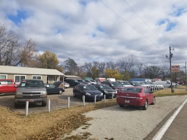
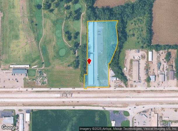
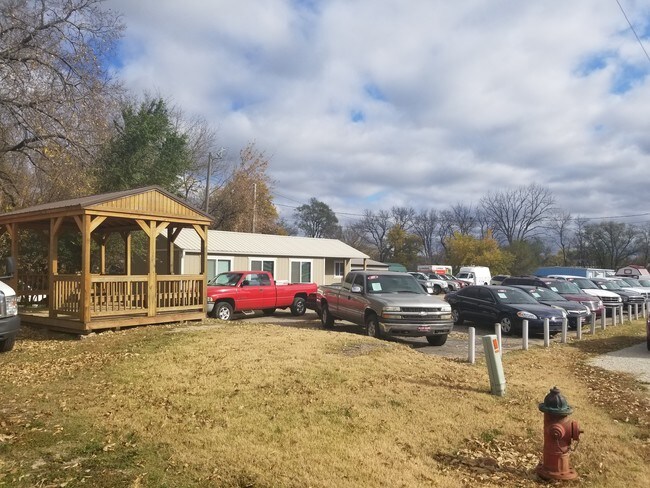
Property Record
660 Ne Us Highway 24, Topeka, KS 66608
NEARBY LISTINGS FOR SALE OR LEASE
Property Detail
660 Ne Us Highway 24
Topeka, KS
Schuster Sub No 3
104-17-0-40-01-021-000
SCHUSTER SUB NO 3, S17, T11, R16, BLOCK A, LOT 1, ACRES 4.38, SCHUSTER SUB NO 3, BLK A, LOT 1
Vehiclerentalsvehiclesales
Shawnee
X
Kansas
20177C0209E
1
2024
4.38 AC
2025
Topeka
000800
Kansas City
448 SF
DEMOGRAPHICS near 660 Ne Us Highway 24
1 Mile
3 Mile
5 Mile
2024 Total Population
2,394
20,606
69,360
2029 Population
2,383
20,531
69,215
Pop Growth 2024-2029
(0.46%)
(0.36%)
(0.21%)
Average Age
41
41
39
2024 Total Households
1,039
8,484
28,023
HH Growth 2024-2029
(0.58%)
(0.41%)
(0.17%)
Median Household Inc
$52,539
$47,343
$47,267
Avg Household Size
2.30
2.30
2.30
2024 Avg HH Vehicles
2.00
2.00
2.00
Median Home Value
$132,129
$96,353
$100,901
Median Year Built
1975
1954
1956
Nearby Places
Map Layers
Map Styles
 Street
 Aerial
- Restaurants
- Banks
- Shops
- Fitness
- Groceries
PUBLIC TRANSPORTATION
COMMUTER RAIL
DRIVE
WALK
Distance
10 min
4.5 mi
SALE & LEASE HISTORY
LISTING DATE
SALE/LEASE

Nov 08, 2018
For Sale
Nearby Properties
Address
Land Use
TOTAL SIZE
Lot Size
Zoning
Address
Land Use
TOTAL SIZE
Lot Size
Zoning
181,781 SF
569.17 AC
R1
Address
Land Use
TOTAL SIZE
Lot Size
Zoning
127,947 SF
7.12 AC
C5
Address
Land Use
TOTAL SIZE
Lot Size
Zoning
129,425 SF
96.26 AC
R1
Address
Land Use
TOTAL SIZE
Lot Size
Zoning
101,766 SF
2.39 AC
C5,I1
Address
Land Use
TOTAL SIZE
Lot Size
Zoning
92,118 SF
10.87 AC
R2
Address
Land Use
TOTAL SIZE
Lot Size
Zoning
70,058 SF
1.03 AC
C5
Address
Land Use
TOTAL SIZE
Lot Size
Zoning
238,319 SF
170.40 AC
PUD,RR1,OI
Address
Land Use
TOTAL SIZE
Lot Size
Zoning
26,269 SF
8.18 AC
RR1
Address
Land Use
TOTAL SIZE
Lot Size
Zoning
18,984 SF
0.35 AC
HL,X3
Address
Land Use
TOTAL SIZE
Lot Size
Zoning
27,718 SF
24.23 AC
RR1
Address
Land Use
TOTAL SIZE
Lot Size
Zoning
63,903 SF
5.05 AC
R2
Address
Land Use
TOTAL SIZE
Lot Size
Zoning
35,055 SF
109.89 AC
RR1
Address
Land Use
TOTAL SIZE
Lot Size
Zoning
96,600 SF
23.56 AC
R1
Address
Land Use
TOTAL SIZE
Lot Size
Zoning
28,978 SF
2.90 AC
PUD,M3
Address
Land Use
TOTAL SIZE
Lot Size
Zoning
72,295 SF
13.39 AC
R1
Address
Land Use
TOTAL SIZE
Lot Size
Zoning
2,595,744 SF
197.79 AC
I2
Address
Land Use
TOTAL SIZE
Lot Size
Zoning
24,462 SF
40.76 AC
OS1
Address
Land Use
TOTAL SIZE
Lot Size
Zoning
12,464 SF
0.35 AC
I2
Address
Land Use
TOTAL SIZE
Lot Size
Zoning
35,320 SF
2.90 AC
R2
Address
Land Use
TOTAL SIZE
Lot Size
Zoning
88,238 SF
32.42 AC
R1,R2
Address
Land Use
TOTAL SIZE
Lot Size
Zoning
18,768 SF
14.94 AC
PUD,M2
Address
Land Use
TOTAL SIZE
Lot Size
Zoning
194,614 SF
23.42 AC
PUD,C4,R1
Address
Land Use
TOTAL SIZE
Lot Size
Zoning
49,341 SF
4.86 AC
D3
Address
Land Use
TOTAL SIZE
Lot Size
Zoning
43,519 SF
1.39 AC
I1
Address
Land Use
TOTAL SIZE
Lot Size
Zoning
10,848 SF
0.52 AC
OI2
Address
Land Use
TOTAL SIZE
Lot Size
Zoning
21,188 SF
0.76 AC
R2
Address
Land Use
TOTAL SIZE
Lot Size
Zoning
14,128 SF
5.18 AC
OS1
Address
Land Use
TOTAL SIZE
Lot Size
Zoning
18,000 SF
1.55 AC
OI2
Address
Land Use
TOTAL SIZE
Lot Size
Zoning
25,910 SF
2.88 AC
D3
Address
Land Use
TOTAL SIZE
Lot Size
Zoning
16,860 SF
2.65 AC
C4
The World's #1 Commercial Real Estate Marketplace
Connect with us
© 2025 CoStar Group
The information above has been obtained from sources believed reliable. While we do not doubt its accuracy we have not verified it and make no guarantee, warranty or representation about it. It is your responsibility to independently confirm its accuracy and completeness. Any projections, opinions, assumptions, or estimates used are for example only and do not represent the current or future performance of the property. The value of this transaction to you depends on tax and other factors which should be evaluated by your tax, financial, and legal advisors. You and your advisors should conduct a careful, independent investigation of the property to determine to your satisfaction the suitability of the property for your needs.