Property Record
660 Sherman Ave, Hamden, CT 06514
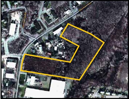
This Property Is For Sale
Property Detail
660 Sherman Ave
HAMD-002929-000165
NEW HAVEN
Industrialacreage
Connecticut
M
0000
B and X Area of moderate flood hazard, usually the area between the limits of the 100-year and 500-year floods.
10.61 AC
2024
Hamden
2025
Westchester/So Connecticut
166004
New Haven, CT
NEARBY LISTINGS FOR SALE OR LEASE
DEMOGRAPHICS near 660 Sherman Ave
1 mile
3 mile
5 mile
2025 Total Population
8,642
38,400
99,869
2030 Population
8,780
39,020
101,350
Pop Growth 2025-2030
+ 1.60%
+ 1.61%
+ 1.48%
Average Age
36
41
43
2025 Total Households
2,574
14,679
39,154
HH Growth 2025-2030
+ 1.63%
+ 1.63%
+ 1.51%
Median Household Inc
$102,762
$105,398
$97,633
Avg Household Size
2.20
2.30
2.40
2025 Avg HH Vehicles
2.00
2.00
2.00
Median Home Value
$305,702
$344,458
$340,853
Median Year Built
1984
1973
1966
Nearby Places
Map Layers
Map Styles
 Street
 Aerial
Transit
 Traffic
 Biking
Places
Listings with unknown addresses are not visible on the map
- Restaurants
- Banks
- Shops
- Fitness
- Groceries
PUBLIC TRANSPORTATION
COMMUTER RAIL
Wallingford Amtrak (Amtrak Hartford Line - Amtrak, Northeast Regional - Amtrak, Valley Flyer - Amtrak)
Drive
Walk
Distance
Wallingford Amtrak (Amtrak Hartford Line - Amtrak, Northeast Regional - Amtrak, Valley Flyer - Amtrak)
12 min
7.0 mi
Wallingford (Hartford Line - CONN DOT)
Drive
Walk
Distance
Wallingford (Hartford Line - CONN DOT)
14 min
7.3 mi
AIRPORT
Tweed/New Haven
Drive
Walk
Distance
Tweed/New Haven
23 min
13.7 mi
Freight Ports
Port of New Haven
Drive
Walk
Distance
Port of New Haven
19 min
11.4 mi
Nearby Properties
Address
Land Use
TOTAL SIZE
Lot Size
Zoning
Address
Land Use
TOTAL SIZE
Lot Size
Zoning
33,122 SF
23.06 AC
T4
Address
Land Use
TOTAL SIZE
Lot Size
Zoning
28,824 SF
44.93 AC
T4
Address
Land Use
TOTAL SIZE
Lot Size
Zoning
15.32 AC
T4
Address
Land Use
TOTAL SIZE
Lot Size
Zoning
30.46 AC
T5
Address
Land Use
TOTAL SIZE
Lot Size
Zoning
116.04 AC
R3
Address
Land Use
TOTAL SIZE
Lot Size
Zoning
18.85 AC
T5
Address
Land Use
TOTAL SIZE
Lot Size
Zoning
57,467 SF
3.72 AC
T4
Address
Land Use
TOTAL SIZE
Lot Size
Zoning
23.48 AC
T5
Address
Land Use
TOTAL SIZE
Lot Size
Zoning
10.91 AC
R5
Address
Land Use
TOTAL SIZE
Lot Size
Zoning
10.77 AC
R5
Address
Land Use
TOTAL SIZE
Lot Size
Zoning
30,272 SF
19.60 AC
R5
Address
Land Use
TOTAL SIZE
Lot Size
Zoning
8.61 AC
R5
Address
Land Use
TOTAL SIZE
Lot Size
Zoning
10.70 AC
IL30
Address
Land Use
TOTAL SIZE
Lot Size
Zoning
119,658 SF
7.48 AC
O12
Address
Land Use
TOTAL SIZE
Lot Size
Zoning
3 AC
T5
Address
Land Use
TOTAL SIZE
Lot Size
Zoning
2.86 AC
R5
Address
Land Use
TOTAL SIZE
Lot Size
Zoning
17,949 SF
8.02 AC
CB40
Address
Land Use
TOTAL SIZE
Lot Size
Zoning
318,092 SF
72.62 AC
I-2
Address
Land Use
TOTAL SIZE
Lot Size
Zoning
64,401 SF
19.16 AC
R3
Address
Land Use
TOTAL SIZE
Lot Size
Zoning
85,974 SF
7.05 AC
T-4
Address
Land Use
TOTAL SIZE
Lot Size
Zoning
123,853 SF
3.70 AC
R5
Address
Land Use
TOTAL SIZE
Lot Size
Zoning
9.80 AC
CA20
Address
Land Use
TOTAL SIZE
Lot Size
Zoning
7.04 AC
R5
Address
Land Use
TOTAL SIZE
Lot Size
Zoning
17.73 AC
IL30
Address
Land Use
TOTAL SIZE
Lot Size
Zoning
4.45 AC
CB40
Address
Land Use
TOTAL SIZE
Lot Size
Zoning
11.88 AC
T5
Address
Land Use
TOTAL SIZE
Lot Size
Zoning
59,567 SF
20.43 AC
T4
Address
Land Use
TOTAL SIZE
Lot Size
Zoning
77,042 SF
39.29 AC
R2
Address
Land Use
TOTAL SIZE
Lot Size
Zoning
8.90 AC
CB40
Address
Land Use
TOTAL SIZE
Lot Size
Zoning
9.20 AC
CB40
The World's #1 Commercial Real Estate Marketplace
Connect with us
© 2026 CoStar Group
The information above has been obtained from sources believed reliable. While we do not doubt its accuracy we have not verified it and make no guarantee, warranty or representation about it. It is your responsibility to independently confirm its accuracy and completeness. Any projections, opinions, assumptions, or estimates used are for example only and do not represent the current or future performance of the property. The value of this transaction to you depends on tax and other factors which should be evaluated by your tax, financial, and legal advisors. You and your advisors should conduct a careful, independent investigation of the property to determine to your satisfaction the suitability of the property for your needs.