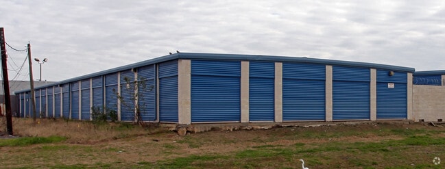
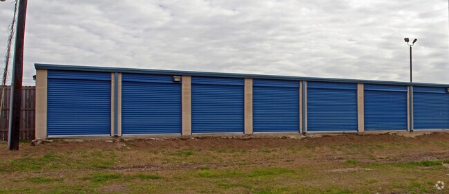
Property Record
6600 I 10 Service Rd, New Orleans, LA 70126
NEARBY LISTINGS FOR SALE OR LEASE
Property Detail
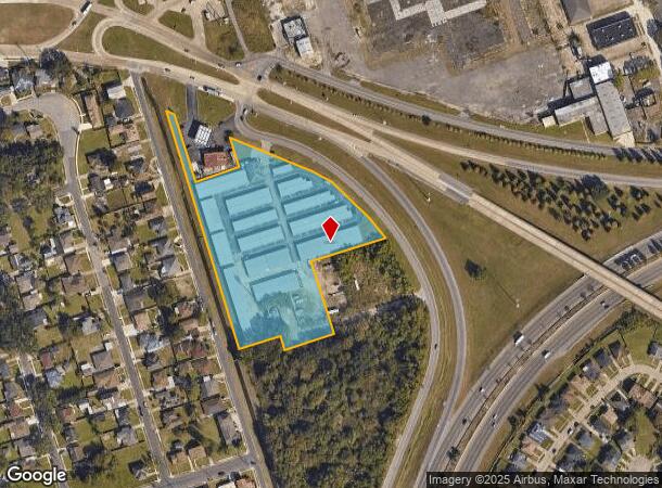
6600 I 10 Service Rd
New Orleans-Metairie, LA
Sec 20
3-9W-0-159-07
SEC 20 LOT 5-Z LAMB RD THRU I-10 776X18X223X150X107X322X287X251X237 X161X43X135 DOCKET 164/10 140 X 150/135-275 SELF STORAGE BLDG (E REC)
Publicstorage
Orleans
AE
Louisiana
22051C0150F
5w
2025
5.37 AC
2025
New Orleans East
001720
New Orleans/Metairie/Kenner
73,252 SF
DEMOGRAPHICS near 6600 I 10 Service Rd
1 Mile
3 Mile
5 Mile
2024 Total Population
13,403
60,401
147,475
2029 Population
12,809
57,586
141,571
Pop Growth 2024-2029
(4.43%)
(4.66%)
(4.00%)
Average Age
38
39
40
2024 Total Households
4,859
22,891
59,800
HH Growth 2024-2029
(4.67%)
(4.95%)
(4.21%)
Median Household Inc
$32,426
$35,145
$37,502
Avg Household Size
2.60
2.50
2.30
2024 Avg HH Vehicles
1.00
1.00
1.00
Median Home Value
$182,656
$187,059
$215,663
Median Year Built
1973
1973
1965
Nearby Places
Map Layers
Map Styles
 Street
 Aerial
- Restaurants
- Banks
- Shops
- Fitness
- Groceries
PUBLIC TRANSPORTATION
AIRPORT
Louis Armstrong New Orleans International
DRIVE
WALK
Distance
Louis Armstrong New Orleans International
26 min
18.4 mi
Nearby Properties
Address
Land Use
TOTAL SIZE
Lot Size
Zoning
Address
Land Use
TOTAL SIZE
Lot Size
Zoning
Address
Land Use
TOTAL SIZE
Lot Size
Zoning
150.60 AC
EC
Address
Land Use
TOTAL SIZE
Lot Size
Zoning
33.64 AC
EC
Address
Land Use
TOTAL SIZE
Lot Size
Zoning
21.35 AC
S-RS
Address
Land Use
TOTAL SIZE
Lot Size
Zoning
189,613 SF
71.45 AC
S-RD
Address
Land Use
TOTAL SIZE
Lot Size
Zoning
8,300 SF
30.83 AC
EC
Address
Land Use
TOTAL SIZE
Lot Size
Zoning
484,670 SF
18.69 AC
EC
Address
Land Use
TOTAL SIZE
Lot Size
Zoning
183.59 AC
OS-R
Address
Land Use
TOTAL SIZE
Lot Size
Zoning
21.58 AC
C-3
Address
Land Use
TOTAL SIZE
Lot Size
Zoning
136,984 SF
11.29 AC
S-RD
Address
Land Use
TOTAL SIZE
Lot Size
Zoning
136,984 SF
4.67 AC
S-RS
Address
Land Use
TOTAL SIZE
Lot Size
Zoning
104,900 SF
7.37 AC
S-RS
Address
Land Use
TOTAL SIZE
Lot Size
Zoning
435,732 SF
29.06 AC
LI
Address
Land Use
TOTAL SIZE
Lot Size
Zoning
31,894 SF
500 AC
MI
Address
Land Use
TOTAL SIZE
Lot Size
Zoning
210,959 SF
6.61 AC
EC
Address
Land Use
TOTAL SIZE
Lot Size
Zoning
13.23 AC
MI
Address
Land Use
TOTAL SIZE
Lot Size
Zoning
99,015 SF
6.99 AC
S-RS
Address
Land Use
TOTAL SIZE
Lot Size
Zoning
94,050 SF
4.96 AC
S-RS
Address
Land Use
TOTAL SIZE
Lot Size
Zoning
98,500 SF
5.54 AC
S-RS
Address
Land Use
TOTAL SIZE
Lot Size
Zoning
4.39 AC
S-RS
Address
Land Use
TOTAL SIZE
Lot Size
Zoning
105,907 SF
3.84 AC
OS-N
Address
Land Use
TOTAL SIZE
Lot Size
Zoning
13,302 SF
53.89 AC
OS-R
Address
Land Use
TOTAL SIZE
Lot Size
Zoning
11.93 AC
S-RS
Address
Land Use
TOTAL SIZE
Lot Size
Zoning
2.48 AC
S-RD
Address
Land Use
TOTAL SIZE
Lot Size
Zoning
205,380 SF
16.49 AC
MS
Address
Land Use
TOTAL SIZE
Lot Size
Zoning
17.83 AC
OS-R
Address
Land Use
TOTAL SIZE
Lot Size
Zoning
114,220 SF
12.09 AC
C-2
Address
Land Use
TOTAL SIZE
Lot Size
Zoning
Address
Land Use
TOTAL SIZE
Lot Size
Zoning
93,584 SF
20.96 AC
S-RS
The World's #1 Commercial Real Estate Marketplace
Connect with us
© 2026 CoStar Group
The information above has been obtained from sources believed reliable. While we do not doubt its accuracy we have not verified it and make no guarantee, warranty or representation about it. It is your responsibility to independently confirm its accuracy and completeness. Any projections, opinions, assumptions, or estimates used are for example only and do not represent the current or future performance of the property. The value of this transaction to you depends on tax and other factors which should be evaluated by your tax, financial, and legal advisors. You and your advisors should conduct a careful, independent investigation of the property to determine to your satisfaction the suitability of the property for your needs.