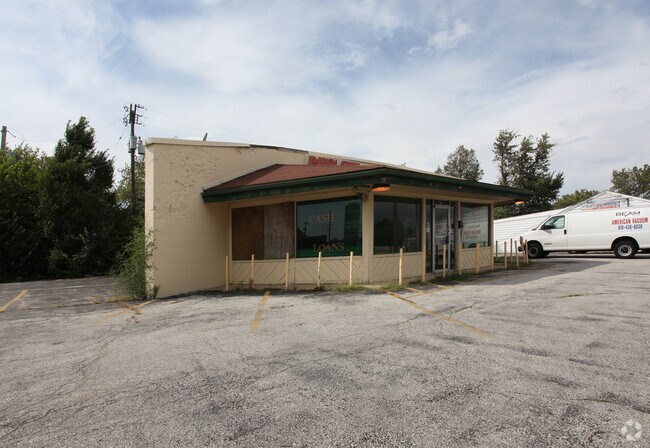
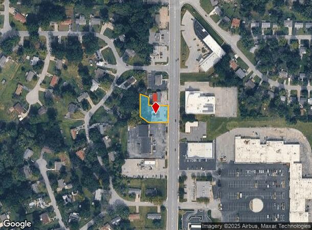
Property Record
6600 N Oak Trfy, Kansas City, MO 64118

NEARBY LISTINGS FOR SALE OR LEASE
Property Detail
6600 N Oak Trfy
Kansas City, MO-KS
Hamilton Heights
13-617-00-14-011.00
HAMILTON HEIGHTS REPLAT LT 1 & E50 LT 8 ALL LT 1 EXC ROW & E50 LT 8
Commercialnec
Clay
ARE
Missouri
29095C0129G
1,8
2024
0.43 AC
2025
I-35 Corridor
021101
Kansas City
DEMOGRAPHICS near 6600 N Oak Trfy
1 Mile
3 Mile
5 Mile
2024 Total Population
12,226
78,709
181,906
2029 Population
12,752
82,907
192,996
Pop Growth 2024-2029
+ 4.30%
+ 5.33%
+ 6.10%
Average Age
39
40
39
2024 Total Households
5,374
33,115
76,739
HH Growth 2024-2029
+ 4.28%
+ 5.32%
+ 6.15%
Median Household Inc
$52,961
$68,189
$69,673
Avg Household Size
2.20
2.30
2.30
2024 Avg HH Vehicles
2.00
2.00
2.00
Median Home Value
$171,833
$209,004
$221,497
Median Year Built
1967
1977
1981
Nearby Places
Map Layers
Map Styles
 Street
 Aerial
- Restaurants
- Banks
- Shops
- Fitness
- Groceries
PUBLIC TRANSPORTATION
AIRPORT
Kansas City International
DRIVE
WALK
Distance
Kansas City International
22 min
13.9 mi
Freight Ports
Tulsa Port Of Catoosa
DRIVE
WALK
Distance
Tulsa Port Of Catoosa
279 min
247.6 mi
Nearby Properties
Address
Land Use
TOTAL SIZE
Lot Size
Zoning
Address
Land Use
TOTAL SIZE
Lot Size
Zoning
820 SF
5.19 AC
Address
Land Use
TOTAL SIZE
Lot Size
Zoning
1.90 AC
Address
Land Use
TOTAL SIZE
Lot Size
Zoning
11.07 AC
Address
Land Use
TOTAL SIZE
Lot Size
Zoning
Address
Land Use
TOTAL SIZE
Lot Size
Zoning
5,044 SF
100.08 AC
Address
Land Use
TOTAL SIZE
Lot Size
Zoning
50.67 AC
Address
Land Use
TOTAL SIZE
Lot Size
Zoning
12.80 AC
Address
Land Use
TOTAL SIZE
Lot Size
Zoning
46.94 AC
Address
Land Use
TOTAL SIZE
Lot Size
Zoning
15.16 AC
Address
Land Use
TOTAL SIZE
Lot Size
Zoning
Address
Land Use
TOTAL SIZE
Lot Size
Zoning
20.78 AC
Address
Land Use
TOTAL SIZE
Lot Size
Zoning
22.13 AC
Address
Land Use
TOTAL SIZE
Lot Size
Zoning
Address
Land Use
TOTAL SIZE
Lot Size
Zoning
16.71 AC
Address
Land Use
TOTAL SIZE
Lot Size
Zoning
4.67 AC
Address
Land Use
TOTAL SIZE
Lot Size
Zoning
14.01 AC
Address
Land Use
TOTAL SIZE
Lot Size
Zoning
13.25 AC
Address
Land Use
TOTAL SIZE
Lot Size
Zoning
9.72 AC
Address
Land Use
TOTAL SIZE
Lot Size
Zoning
1,763 SF
10.06 AC
Address
Land Use
TOTAL SIZE
Lot Size
Zoning
Address
Land Use
TOTAL SIZE
Lot Size
Zoning
5.64 AC
Address
Land Use
TOTAL SIZE
Lot Size
Zoning
11.03 AC
Address
Land Use
TOTAL SIZE
Lot Size
Zoning
5.69 AC
Address
Land Use
TOTAL SIZE
Lot Size
Zoning
Address
Land Use
TOTAL SIZE
Lot Size
Zoning
4.15 AC
Address
Land Use
TOTAL SIZE
Lot Size
Zoning
15.14 AC
Address
Land Use
TOTAL SIZE
Lot Size
Zoning
Address
Land Use
TOTAL SIZE
Lot Size
Zoning
3.37 AC
Address
Land Use
TOTAL SIZE
Lot Size
Zoning
Address
Land Use
TOTAL SIZE
Lot Size
Zoning
13.01 AC
The World's #1 Commercial Real Estate Marketplace
Connect with us
© 2025 CoStar Group
The information above has been obtained from sources believed reliable. While we do not doubt its accuracy we have not verified it and make no guarantee, warranty or representation about it. It is your responsibility to independently confirm its accuracy and completeness. Any projections, opinions, assumptions, or estimates used are for example only and do not represent the current or future performance of the property. The value of this transaction to you depends on tax and other factors which should be evaluated by your tax, financial, and legal advisors. You and your advisors should conduct a careful, independent investigation of the property to determine to your satisfaction the suitability of the property for your needs.