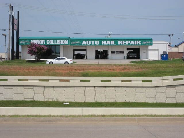
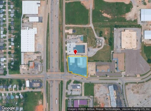
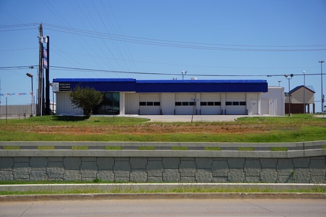
Property Record
6620 S I 35 Service Rd, Oklahoma City, OK 73149
NEARBY LISTINGS FOR SALE OR LEASE
Property Detail
6620 S I 35 Service Rd
Oklahoma City, OK
Flynn Hill Add
086335625
FLYNN HILL ADD 000 000 PT LOT 8 BEG 75FT N OF SE/C LOT 8 TH N200FT W274.52FT TH SLY ALONG E R/W LINE OF INTERSTATE H/W 35 200.29FT E263.87FT TO BEG PLUS BEG 10FT N OF SE/C BLK 8 TH NWLY204.27FT N23.32FT E199.94FT S65FT TO BEG SUBJ TO ESMTS OF RECORD
Autorepair
Oklahoma
X
Oklahoma
40109C0315H
8
2023
1.41 AC
2024
South
107303
Oklahoma City
14,132 SF
DEMOGRAPHICS near 6620 S I 35 Service Rd
1 Mile
3 Mile
5 Mile
2024 Total Population
4,215
76,036
238,715
2029 Population
4,338
78,333
246,576
Pop Growth 2024-2029
+ 2.92%
+ 3.02%
+ 3.29%
Average Age
35
35
36
2024 Total Households
1,424
28,297
88,822
HH Growth 2024-2029
+ 3.02%
+ 3.11%
+ 3.40%
Median Household Inc
$42,121
$43,900
$51,391
Avg Household Size
2.90
2.60
2.60
2024 Avg HH Vehicles
2.00
2.00
2.00
Median Home Value
$77,489
$109,729
$129,663
Median Year Built
1963
1972
1974
Nearby Places
- Restaurants
- Banks
- Shops
- Fitness
- Groceries
PUBLIC TRANSPORTATION
COMMUTER RAIL
Oklahoma City (Heartland Flyer - Amtrak)
DRIVE
WALK
Distance
Oklahoma City (Heartland Flyer - Amtrak)
9 min
5.9 mi
AIRPORT
Will Rogers World
DRIVE
WALK
Distance
Will Rogers World
18 min
8.8 mi
Freight Ports
Tulsa Port Of Catoosa
DRIVE
WALK
Distance
Tulsa Port Of Catoosa
138 min
127.1 mi
SALE & LEASE HISTORY
LISTING DATE
SALE/LEASE

Sep 25, 2016
For Lease
Oct 03, 2016
For Lease
Oct 03, 2016
For Sale
Nearby Properties
Address
Land Use
TOTAL SIZE
Lot Size
Zoning
Address
Land Use
TOTAL SIZE
Lot Size
Zoning
50.08 AC
Address
Land Use
TOTAL SIZE
Lot Size
Zoning
2,123 SF
53.41 AC
C3
Address
Land Use
TOTAL SIZE
Lot Size
Zoning
155.94 AC
Address
Land Use
TOTAL SIZE
Lot Size
Zoning
57,536 SF
66.21 AC
R4
Address
Land Use
TOTAL SIZE
Lot Size
Zoning
Address
Land Use
TOTAL SIZE
Lot Size
Zoning
64,658 SF
1.86 AC
SPUD
Address
Land Use
TOTAL SIZE
Lot Size
Zoning
Address
Land Use
TOTAL SIZE
Lot Size
Zoning
Address
Land Use
TOTAL SIZE
Lot Size
Zoning
347,050 SF
18.56 AC
Address
Land Use
TOTAL SIZE
Lot Size
Zoning
40.90 AC
Address
Land Use
TOTAL SIZE
Lot Size
Zoning
998,813 SF
167.96 AC
I-2
Address
Land Use
TOTAL SIZE
Lot Size
Zoning
70.01 AC
Address
Land Use
TOTAL SIZE
Lot Size
Zoning
232,037 SF
18.80 AC
C-3
Address
Land Use
TOTAL SIZE
Lot Size
Zoning
403,745 SF
26.03 AC
I-3
Address
Land Use
TOTAL SIZE
Lot Size
Zoning
2.55 AC
Address
Land Use
TOTAL SIZE
Lot Size
Zoning
35.11 AC
Address
Land Use
TOTAL SIZE
Lot Size
Zoning
296,429 SF
33.05 AC
I-2
Address
Land Use
TOTAL SIZE
Lot Size
Zoning
303,996 SF
14.90 AC
Address
Land Use
TOTAL SIZE
Lot Size
Zoning
312,675 SF
25.01 AC
Address
Land Use
TOTAL SIZE
Lot Size
Zoning
10,110 SF
10 AC
Address
Land Use
TOTAL SIZE
Lot Size
Zoning
3.58 AC
AA
Address
Land Use
TOTAL SIZE
Lot Size
Zoning
3.84 AC
AA
Address
Land Use
TOTAL SIZE
Lot Size
Zoning
81,929 SF
8.65 AC
PUD
Address
Land Use
TOTAL SIZE
Lot Size
Zoning
0.34 AC
Address
Land Use
TOTAL SIZE
Lot Size
Zoning
512,046 SF
41.53 AC
I-2
Address
Land Use
TOTAL SIZE
Lot Size
Zoning
152,302 SF
14 AC
Address
Land Use
TOTAL SIZE
Lot Size
Zoning
392,100 SF
7.87 AC
I-2
Address
Land Use
TOTAL SIZE
Lot Size
Zoning
18,999 SF
2.92 AC
Address
Land Use
TOTAL SIZE
Lot Size
Zoning
231,671 SF
12.41 AC
RM
Address
Land Use
TOTAL SIZE
Lot Size
Zoning
296,700 SF
9.17 AC
I-2
The World's #1 Commercial Real Estate Marketplace
Connect with us
© 2025 CoStar Group
The information above has been obtained from sources believed reliable. While we do not doubt its accuracy we have not verified it and make no guarantee, warranty or representation about it. It is your responsibility to independently confirm its accuracy and completeness. Any projections, opinions, assumptions, or estimates used are for example only and do not represent the current or future performance of the property. The value of this transaction to you depends on tax and other factors which should be evaluated by your tax, financial, and legal advisors. You and your advisors should conduct a careful, independent investigation of the property to determine to your satisfaction the suitability of the property for your needs.