Property Record
6601 S 205Th St, Elkhorn, NE 68022
NEARBY LISTINGS FOR SALE OR LEASE
Property Detail
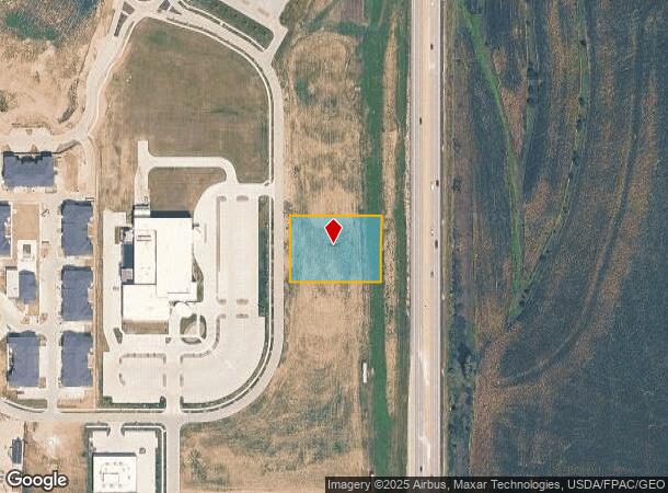
6601 S 205Th St
Omaha-Council Bluffs, NE-IA
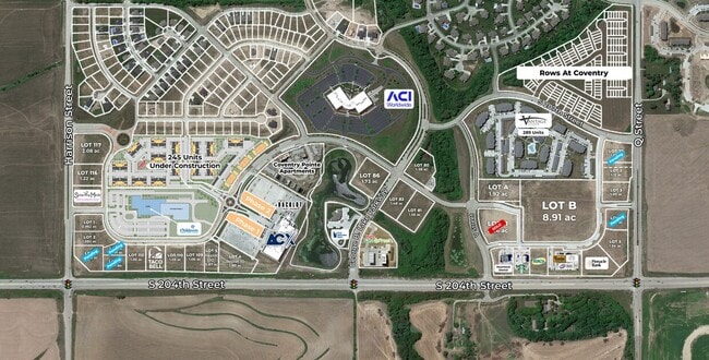
Coventry
0001-3250-09
COVENTRY LOT 111 BLOCK 0 LOT 111 1.01 AC
Restaurantdrivein
Douglas
X
Nebraska
31153C0030H
111
2024
1.01 AC
2025
Southwest Omaha
007509
Omaha/Council Bluffs
2,364 SF
DEMOGRAPHICS near 6601 S 205Th St
1 Mile
3 Mile
5 Mile
2024 Total Population
5,074
42,892
120,986
2029 Population
5,461
45,256
126,139
Pop Growth 2024-2029
+ 7.63%
+ 5.51%
+ 4.26%
Average Age
34
35
37
2024 Total Households
1,650
13,926
41,990
HH Growth 2024-2029
+ 7.15%
+ 5.44%
+ 4.13%
Median Household Inc
$144,661
$132,686
$122,435
Avg Household Size
3.00
3.10
2.80
2024 Avg HH Vehicles
2.00
2.00
2.00
Median Home Value
$360,946
$325,247
$312,591
Median Year Built
2010
2007
2002
Nearby Places
Map Layers
Map Styles
 Street
 Aerial
- Restaurants
- Banks
- Shops
- Fitness
- Groceries
PUBLIC TRANSPORTATION
AIRPORT
Eppley Airfield
DRIVE
WALK
Distance
Eppley Airfield
40 min
24.7 mi
Freight Ports
Tulsa Port Of Catoosa
DRIVE
WALK
Distance
Tulsa Port Of Catoosa
480 min
429.3 mi
Nearby Properties
Address
Land Use
TOTAL SIZE
Lot Size
Zoning
Address
Land Use
TOTAL SIZE
Lot Size
Zoning
72.91 AC
Address
Land Use
TOTAL SIZE
Lot Size
Zoning
349,722 SF
25.22 AC
R6
Address
Land Use
TOTAL SIZE
Lot Size
Zoning
391,191 SF
87.18 AC
GI
Address
Land Use
TOTAL SIZE
Lot Size
Zoning
394,017 SF
11.62 AC
Address
Land Use
TOTAL SIZE
Lot Size
Zoning
277,073 SF
16.78 AC
Address
Land Use
TOTAL SIZE
Lot Size
Zoning
165,950 SF
11.57 AC
MH
Address
Land Use
TOTAL SIZE
Lot Size
Zoning
240,630 SF
5.38 AC
Address
Land Use
TOTAL SIZE
Lot Size
Zoning
257,106 SF
21.44 AC
R6
Address
Land Use
TOTAL SIZE
Lot Size
Zoning
13,312 SF
9.27 AC
Address
Land Use
TOTAL SIZE
Lot Size
Zoning
193,490 SF
9.35 AC
Address
Land Use
TOTAL SIZE
Lot Size
Zoning
28,444 SF
0.85 AC
Address
Land Use
TOTAL SIZE
Lot Size
Zoning
387,400 SF
6.13 AC
Address
Land Use
TOTAL SIZE
Lot Size
Zoning
52,791 SF
8.09 AC
Address
Land Use
TOTAL SIZE
Lot Size
Zoning
134,709 SF
2.32 AC
MU
Address
Land Use
TOTAL SIZE
Lot Size
Zoning
138,942 SF
2.86 AC
Address
Land Use
TOTAL SIZE
Lot Size
Zoning
36,145 SF
2 AC
Address
Land Use
TOTAL SIZE
Lot Size
Zoning
32,049 SF
5.70 AC
Address
Land Use
TOTAL SIZE
Lot Size
Zoning
107,577 SF
4.24 AC
Address
Land Use
TOTAL SIZE
Lot Size
Zoning
39,264 SF
1.67 AC
RG35
Address
Land Use
TOTAL SIZE
Lot Size
Zoning
9,083 SF
2.56 AC
Address
Land Use
TOTAL SIZE
Lot Size
Zoning
78,656 SF
8.63 AC
MU
Address
Land Use
TOTAL SIZE
Lot Size
Zoning
11,534 SF
74.14 AC
AG
Address
Land Use
TOTAL SIZE
Lot Size
Zoning
63,241 SF
3.13 AC
Address
Land Use
TOTAL SIZE
Lot Size
Zoning
30,415 SF
3.26 AC
Address
Land Use
TOTAL SIZE
Lot Size
Zoning
57,700 SF
10.04 AC
Address
Land Use
TOTAL SIZE
Lot Size
Zoning
1,344 SF
10.41 AC
Address
Land Use
TOTAL SIZE
Lot Size
Zoning
3,943 SF
75.50 AC
Address
Land Use
TOTAL SIZE
Lot Size
Zoning
21,509 SF
4.52 AC
Address
Land Use
TOTAL SIZE
Lot Size
Zoning
62,960 SF
3.62 AC
Address
Land Use
TOTAL SIZE
Lot Size
Zoning
8,225 SF
6.47 AC
The World's #1 Commercial Real Estate Marketplace
Connect with us
© 2025 CoStar Group
The information above has been obtained from sources believed reliable. While we do not doubt its accuracy we have not verified it and make no guarantee, warranty or representation about it. It is your responsibility to independently confirm its accuracy and completeness. Any projections, opinions, assumptions, or estimates used are for example only and do not represent the current or future performance of the property. The value of this transaction to you depends on tax and other factors which should be evaluated by your tax, financial, and legal advisors. You and your advisors should conduct a careful, independent investigation of the property to determine to your satisfaction the suitability of the property for your needs.