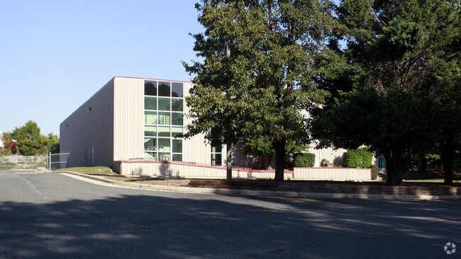
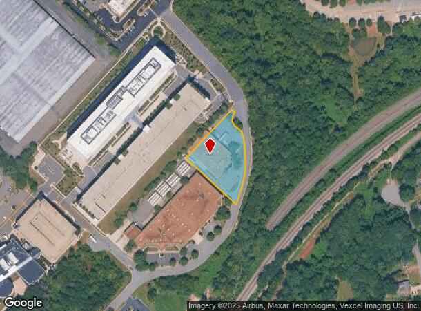
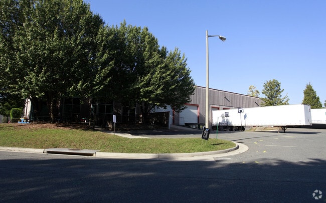
Property Record
6601 Springfield Center Dr, Springfield, VA 22150
Current Lease Availabilities
NEARBY LISTINGS FOR SALE OR LEASE
Property Detail
6601 Springfield Center Dr
Washington-Arlington-Alexandria, DC-VA-MD-WV
Springfield Centr
0902-01-0058D
SPRINGFIELD CENTR INDUSTRIAL PARK LT 6601
Miscellaneous
Fairfax
X
Virginia
5100540050D
58d
2024
1.32 AC
2025
Newington
421002
Washington, DC
26,496 SF
DEMOGRAPHICS near 6601 Springfield Center Dr
1 Mile
3 Mile
5 Mile
2024 Total Population
10,738
97,517
335,809
2029 Population
10,536
95,980
329,605
Pop Growth 2024-2029
(1.88%)
(1.58%)
(1.85%)
Average Age
38
40
39
2024 Total Households
3,704
35,087
120,343
HH Growth 2024-2029
(2.00%)
(1.72%)
(2.04%)
Median Household Inc
$113,172
$133,100
$114,550
Avg Household Size
2.80
2.70
2.70
2024 Avg HH Vehicles
2.00
2.00
2.00
Median Home Value
$533,691
$595,094
$572,613
Median Year Built
1985
1984
1978
Nearby Places
- Restaurants
- Banks
- Shops
- Fitness
- Groceries
PUBLIC TRANSPORTATION
TRANSIT/SUBWAY
Franconia-Springfield (Blue Line - Washington Metropolitan Area Transit Authority Metrorail (Metrorail))
DRIVE
WALK
Distance
Franconia-Springfield (Blue Line - Washington Metropolitan Area Transit Authority Metrorail (Metrorail))
3 min
13 min
0.6 mi
Franconia-Springfield (Fredericksburg Line - Virginia Railway Express)
DRIVE
WALK
Distance
Franconia-Springfield (Fredericksburg Line - Virginia Railway Express)
9 min
13 min
0.7 mi
COMMUTER RAIL
Franconia-Springfield (Fredericksburg Line - Virginia Railway Express)
DRIVE
WALK
Distance
Franconia-Springfield (Fredericksburg Line - Virginia Railway Express)
9 min
13 min
0.7 mi
Backlick Road (Manassas Line - Virginia Railway Express)
DRIVE
WALK
Distance
Backlick Road (Manassas Line - Virginia Railway Express)
9 min
3.2 mi
AIRPORT
Ronald Reagan Washington Ntl
DRIVE
WALK
Distance
Ronald Reagan Washington Ntl
23 min
11.9 mi
Washington Dulles International
DRIVE
WALK
Distance
Washington Dulles International
47 min
28.4 mi
Baltimore/Washington International Thurgood Marshall
DRIVE
WALK
Distance
Baltimore/Washington International Thurgood Marshall
71 min
45.6 mi
Freight Ports
Port of Baltimore
DRIVE
WALK
Distance
Port of Baltimore
80 min
52.8 mi
Nearby Properties
Address
Land Use
TOTAL SIZE
Lot Size
Zoning
Address
Land Use
TOTAL SIZE
Lot Size
Zoning
717,618 SF
16.81 AC
340
Address
Land Use
TOTAL SIZE
Lot Size
Zoning
824,193 SF
16.06 AC
400
Address
Land Use
TOTAL SIZE
Lot Size
Zoning
631,189 SF
9.48 AC
497
Address
Land Use
TOTAL SIZE
Lot Size
Zoning
2,239,442 SF
58.08 AC
130
Address
Land Use
TOTAL SIZE
Lot Size
Zoning
480,165 SF
21.23 AC
304
Address
Land Use
TOTAL SIZE
Lot Size
Zoning
73,835 SF
27.26 AC
540
Address
Land Use
TOTAL SIZE
Lot Size
Zoning
1,286,047 SF
69.60 AC
540
Address
Land Use
TOTAL SIZE
Lot Size
Zoning
429,735 SF
20 AC
560
Address
Land Use
TOTAL SIZE
Lot Size
Zoning
329,637 SF
23.39 AC
316
Address
Land Use
TOTAL SIZE
Lot Size
Zoning
338,106 SF
26.50 AC
304
Address
Land Use
TOTAL SIZE
Lot Size
Zoning
226,270 SF
21.98 AC
400
Address
Land Use
TOTAL SIZE
Lot Size
Zoning
187,773 SF
23.18 AC
304
Address
Land Use
TOTAL SIZE
Lot Size
Zoning
452,682 SF
20.74 AC
220
Address
Land Use
TOTAL SIZE
Lot Size
Zoning
394,657 SF
10.47 AC
340
Address
Land Use
TOTAL SIZE
Lot Size
Zoning
357,064 SF
19.14 AC
540
Address
Land Use
TOTAL SIZE
Lot Size
Zoning
1,000 SF
23.41 AC
550
Address
Land Use
TOTAL SIZE
Lot Size
Zoning
327,600 SF
12.31 AC
304
Address
Land Use
TOTAL SIZE
Lot Size
Zoning
726,779 SF
57.50 AC
130
Address
Land Use
TOTAL SIZE
Lot Size
Zoning
173,702 SF
6.72 AC
316
Address
Land Use
TOTAL SIZE
Lot Size
Zoning
374,125 SF
2.84 AC
400
Address
Land Use
TOTAL SIZE
Lot Size
Zoning
164,037 SF
21.72 AC
550
Address
Land Use
TOTAL SIZE
Lot Size
Zoning
281,630 SF
16.07 AC
540
Address
Land Use
TOTAL SIZE
Lot Size
Zoning
398,419 SF
18.54 AC
560
Address
Land Use
TOTAL SIZE
Lot Size
Zoning
171,711 SF
16.08 AC
480
Address
Land Use
TOTAL SIZE
Lot Size
Zoning
270,191 SF
1.83 AC
440
Address
Land Use
TOTAL SIZE
Lot Size
Zoning
188,000 SF
4.54 AC
400
Address
Land Use
TOTAL SIZE
Lot Size
Zoning
158,919 SF
6.15 AC
316
Address
Land Use
TOTAL SIZE
Lot Size
Zoning
106,170 SF
8.39 AC
460
Address
Land Use
TOTAL SIZE
Lot Size
Zoning
253,648 SF
10.72 AC
550
Address
Land Use
TOTAL SIZE
Lot Size
Zoning
94,712 SF
8.44 AC
304
The World's #1 Commercial Real Estate Marketplace
Connect with us
© 2025 CoStar Group
The information above has been obtained from sources believed reliable. While we do not doubt its accuracy we have not verified it and make no guarantee, warranty or representation about it. It is your responsibility to independently confirm its accuracy and completeness. Any projections, opinions, assumptions, or estimates used are for example only and do not represent the current or future performance of the property. The value of this transaction to you depends on tax and other factors which should be evaluated by your tax, financial, and legal advisors. You and your advisors should conduct a careful, independent investigation of the property to determine to your satisfaction the suitability of the property for your needs.