Property Record
6601 Vaught Ranch Rd, Austin, TX 78730
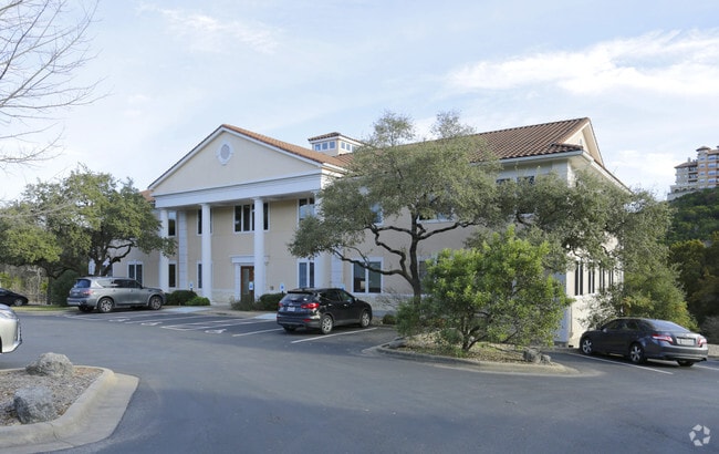

Property Detail
6601 Vaught Ranch Rd
Austin-Round Rock-San Marcos, TX
LOT 1 BLK A BHN SUBD
457092
Travis
Officebuilding
Texas
B and X Area of moderate flood hazard, usually the area between the limits of the 100-year and 500-year floods.
1
2025
1.90 AC
2025
Northwest
032900
Austin
16,832 SF
NEARBY LISTINGS FOR SALE OR LEASE
DEMOGRAPHICS near 6601 Vaught Ranch Rd
1 mile
3 mile
5 mile
2025 Total Population
2,624
31,959
143,770
2030 Population
2,712
32,989
149,738
Pop Growth 2025-2030
+ 3.35%
+ 3.22%
+ 4.15%
Average Age
42
43
41
2025 Total Households
1,271
13,686
63,808
HH Growth 2025-2030
+ 4.09%
+ 3.95%
+ 5.00%
Median Household Inc
$139,386
$163,612
$120,401
Avg Household Size
2.10
2.30
2.20
2025 Avg HH Vehicles
2.00
2.00
2.00
Median Home Value
$996,428
$968,351
$842,869
Median Year Built
1998
1992
1989
Nearby Places
Map Layers
Map Styles
 Street
 Aerial
Transit
 Traffic
 Biking
Places
Listings with unknown addresses are not visible on the map
- Restaurants
- Banks
- Shops
- Fitness
- Groceries
PUBLIC TRANSPORTATION
AIRPORT
Austin-Bergstrom International
Drive
Walk
Distance
Austin-Bergstrom International
38 min
22.4 mi
Freight Ports
Calhoun Port
Drive
Walk
Distance
Calhoun Port
203 min
165.9 mi
SALE & LEASE HISTORY
LISTING DATE
SALE/LEASE

May 11, 2018
For Lease
Feb 28, 2024
For Lease
Nearby Properties
Address
Land Use
TOTAL SIZE
Lot Size
Zoning
Address
Land Use
TOTAL SIZE
Lot Size
Zoning
1,396,406 SF
107.21 AC
Address
Land Use
TOTAL SIZE
Lot Size
Zoning
485,130 SF
28.07 AC
Address
Land Use
TOTAL SIZE
Lot Size
Zoning
494,958 SF
39.50 AC
Address
Land Use
TOTAL SIZE
Lot Size
Zoning
133,092 SF
54.32 AC
Address
Land Use
TOTAL SIZE
Lot Size
Zoning
342,992 SF
17.53 AC
Address
Land Use
TOTAL SIZE
Lot Size
Zoning
344,561 SF
41.25 AC
Address
Land Use
TOTAL SIZE
Lot Size
Zoning
332,202 SF
31.81 AC
Address
Land Use
TOTAL SIZE
Lot Size
Zoning
366,805 SF
23.78 AC
Address
Land Use
TOTAL SIZE
Lot Size
Zoning
349,535 SF
245.89 AC
Address
Land Use
TOTAL SIZE
Lot Size
Zoning
638,467 SF
47.71 AC
Address
Land Use
TOTAL SIZE
Lot Size
Zoning
310,609 SF
51.42 AC
Address
Land Use
TOTAL SIZE
Lot Size
Zoning
560,549 SF
8.07 AC
Address
Land Use
TOTAL SIZE
Lot Size
Zoning
250,000 SF
9.22 AC
Address
Land Use
TOTAL SIZE
Lot Size
Zoning
276,728 SF
16.25 AC
Address
Land Use
TOTAL SIZE
Lot Size
Zoning
202,346 SF
16.50 AC
Address
Land Use
TOTAL SIZE
Lot Size
Zoning
280,524 SF
30.38 AC
Address
Land Use
TOTAL SIZE
Lot Size
Zoning
174,806 SF
11.29 AC
Address
Land Use
TOTAL SIZE
Lot Size
Zoning
185,001 SF
10.82 AC
Address
Land Use
TOTAL SIZE
Lot Size
Zoning
112,455 SF
21.04 AC
Address
Land Use
TOTAL SIZE
Lot Size
Zoning
231,083 SF
28.79 AC
Address
Land Use
TOTAL SIZE
Lot Size
Zoning
178,606 SF
8.78 AC
Address
Land Use
TOTAL SIZE
Lot Size
Zoning
942.27 AC
Address
Land Use
TOTAL SIZE
Lot Size
Zoning
71,429 SF
6.89 AC
Address
Land Use
TOTAL SIZE
Lot Size
Zoning
105,222 SF
3.20 AC
Address
Land Use
TOTAL SIZE
Lot Size
Zoning
199,718 SF
5.55 AC
Address
Land Use
TOTAL SIZE
Lot Size
Zoning
367,726 SF
20.53 AC
Address
Land Use
TOTAL SIZE
Lot Size
Zoning
117,195 SF
4.56 AC
Address
Land Use
TOTAL SIZE
Lot Size
Zoning
87,324 SF
8.98 AC
Address
Land Use
TOTAL SIZE
Lot Size
Zoning
128,040 SF
14.99 AC
Address
Land Use
TOTAL SIZE
Lot Size
Zoning
60,102 SF
7.33 AC
The World's #1 Commercial Real Estate Marketplace
Connect with us
© 2026 CoStar Group
The information above has been obtained from sources believed reliable. While we do not doubt its accuracy we have not verified it and make no guarantee, warranty or representation about it. It is your responsibility to independently confirm its accuracy and completeness. Any projections, opinions, assumptions, or estimates used are for example only and do not represent the current or future performance of the property. The value of this transaction to you depends on tax and other factors which should be evaluated by your tax, financial, and legal advisors. You and your advisors should conduct a careful, independent investigation of the property to determine to your satisfaction the suitability of the property for your needs.