Property Record
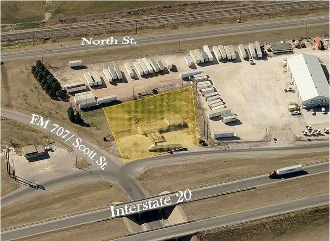
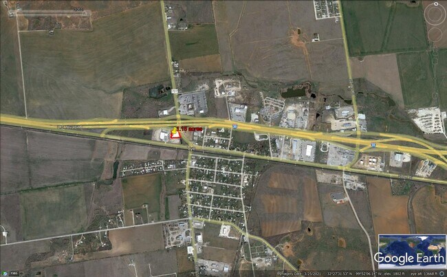
101 N Fm 707 St, Merkel, TX 79536

Property Detail
101 N Fm 707 St
95973
ORIGINAL TOWN TYE, BLOCK PRT 23-25-29 & ALL BLK 24, ACRES 13.484
Multipleuses
TAYLOR
A Areas with a 1% annual chance of flooding and a 26% chance of flooding over the life of a 30-year mortgage.
Texas
2024
13.48 AC
2025
Abilene
013602
Other Market Areas
19,607 SF
Abilene, TX
NEARBY LISTINGS FOR SALE OR LEASE
-
-
View all Merkel listings for sale on LoopNet.com
DEMOGRAPHICS near 101 N Fm 707 St
1 mile
3 mile
5 mile
2025 Total Population
525
4,681
15,626
2030 Population
550
5,430
16,965
Pop Growth 2025-2030
+ 4.76%
+ 16.00%
+ 8.57%
Average Age
41
33
33
2025 Total Households
203
1,679
5,513
HH Growth 2025-2030
+ 5.42%
+ 17.27%
+ 9.11%
Median Household Inc
$47,954
$79,225
$60,773
Avg Household Size
2.60
2.60
2.70
2025 Avg HH Vehicles
2.00
2.00
2.00
Median Home Value
$58,799
$418,097
$162,521
Median Year Built
1989
2011
1995
Nearby Places
Map Layers
Map Styles
 Street
 Aerial
Layers
 Traffic
 Biking
Places
Listings with unknown addresses are not visible on the map
- Restaurants
- Banks
- Shops
- Fitness
- Groceries
PUBLIC TRANSPORTATION
AIRPORT
Abilene Regional
Drive
Walk
Distance
Abilene Regional
22 min
16.6 mi
Freight Ports
Calhoun Port
Drive
Walk
Distance
Calhoun Port
443 min
380.8 mi
SALE & LEASE HISTORY
LISTING DATE
SALE/LEASE

Sep 24, 2016
For Sale
Jan 31, 2017
For Sale
Nearby Properties
Address
Land Use
TOTAL SIZE
Lot Size
Zoning
Address
Land Use
TOTAL SIZE
Lot Size
Zoning
48,515 SF
5.99 AC
Address
Land Use
TOTAL SIZE
Lot Size
Zoning
21,296 SF
6.47 AC
Address
Land Use
TOTAL SIZE
Lot Size
Zoning
39,470 SF
8.48 AC
Address
Land Use
TOTAL SIZE
Lot Size
Zoning
38,140 SF
7 AC
Address
Land Use
TOTAL SIZE
Lot Size
Zoning
26,997 SF
10.69 AC
Address
Land Use
TOTAL SIZE
Lot Size
Zoning
46,705 SF
10.56 AC
Address
Land Use
TOTAL SIZE
Lot Size
Zoning
30,171 SF
6.45 AC
Address
Land Use
TOTAL SIZE
Lot Size
Zoning
14,896 SF
3.86 AC
Address
Land Use
TOTAL SIZE
Lot Size
Zoning
4,280 SF
25 AC
Address
Land Use
TOTAL SIZE
Lot Size
Zoning
31,750 SF
9.57 AC
Address
Land Use
TOTAL SIZE
Lot Size
Zoning
14,690 SF
158.23 AC
Address
Land Use
TOTAL SIZE
Lot Size
Zoning
10,857 SF
1.12 AC
Address
Land Use
TOTAL SIZE
Lot Size
Zoning
3,927 SF
11.32 AC
Address
Land Use
TOTAL SIZE
Lot Size
Zoning
65,404 SF
7.08 AC
Address
Land Use
TOTAL SIZE
Lot Size
Zoning
16,576 SF
30.09 AC
Address
Land Use
TOTAL SIZE
Lot Size
Zoning
14,361 SF
1.97 AC
Address
Land Use
TOTAL SIZE
Lot Size
Zoning
7,500 SF
5 AC
Address
Land Use
TOTAL SIZE
Lot Size
Zoning
14,052 SF
5 AC
Address
Land Use
TOTAL SIZE
Lot Size
Zoning
16,893 SF
5.01 AC
Address
Land Use
TOTAL SIZE
Lot Size
Zoning
8,030 SF
7.49 AC
Address
Land Use
TOTAL SIZE
Lot Size
Zoning
3,040 SF
1.02 AC
Address
Land Use
TOTAL SIZE
Lot Size
Zoning
10,539 SF
35 AC
Address
Land Use
TOTAL SIZE
Lot Size
Zoning
6.25 AC
Address
Land Use
TOTAL SIZE
Lot Size
Zoning
5,000 SF
10.26 AC
Address
Land Use
TOTAL SIZE
Lot Size
Zoning
19,818 SF
9.14 AC
Address
Land Use
TOTAL SIZE
Lot Size
Zoning
9,600 SF
2.72 AC
Address
Land Use
TOTAL SIZE
Lot Size
Zoning
2.02 AC
Address
Land Use
TOTAL SIZE
Lot Size
Zoning
13,426 SF
9.78 AC
Address
Land Use
TOTAL SIZE
Lot Size
Zoning
217.32 AC
The World's #1 Commercial Real Estate Marketplace
Connect with us
© 2026 CoStar Group
The information above has been obtained from sources believed reliable. While we do not doubt its accuracy we have not verified it and make no guarantee, warranty or representation about it. It is your responsibility to independently confirm its accuracy and completeness. Any projections, opinions, assumptions, or estimates used are for example only and do not represent the current or future performance of the property. The value of this transaction to you depends on tax and other factors which should be evaluated by your tax, financial, and legal advisors. You and your advisors should conduct a careful, independent investigation of the property to determine to your satisfaction the suitability of the property for your needs.