Property Record
6607 S Pleasant Valley Rd, Austin, TX 78744


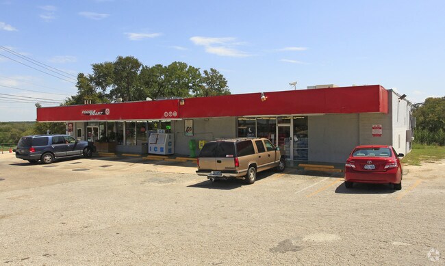

Property Detail
6607 S Pleasant Valley Rd
Austin-Round Rock-San Marcos, TX
LOT 1A *RESUB OF LOT 1 ONION CREEK FOREST SEC 3
296345
Travis
Storebuilding
Texas
B and X Area of moderate flood hazard, usually the area between the limits of the 100-year and 500-year floods.
1a,1
2025
0.40 AC
2025
Southeast
002430
Austin
3,800 SF
NEARBY LISTINGS FOR SALE OR LEASE
DEMOGRAPHICS near 6607 S Pleasant Valley Rd
1 mile
3 mile
5 mile
2025 Total Population
12,321
91,871
257,236
2030 Population
12,641
96,908
271,119
Pop Growth 2025-2030
+ 2.60%
+ 5.48%
+ 5.40%
Average Age
36
36
36
2025 Total Households
3,603
34,876
110,991
HH Growth 2025-2030
+ 3.41%
+ 6.29%
+ 6.06%
Median Household Inc
$85,046
$79,550
$82,241
Avg Household Size
3.30
2.50
2.20
2025 Avg HH Vehicles
2.00
2.00
2.00
Median Home Value
$329,462
$423,513
$484,011
Median Year Built
1990
2004
2000
Nearby Places
Map Layers
Map Styles
 Street
 Aerial
Layers
 Traffic
 Biking
Places
Listings with unknown addresses are not visible on the map
- Restaurants
- Banks
- Shops
- Fitness
- Groceries
PUBLIC TRANSPORTATION
COMMUTER RAIL
Austin (Texas Eagle - Amtrak)
Drive
Walk
Distance
Austin (Texas Eagle - Amtrak)
15 min
9.1 mi
AIRPORT
Austin-Bergstrom International
Drive
Walk
Distance
Austin-Bergstrom International
20 min
8.8 mi
Freight Ports
Calhoun Port
Drive
Walk
Distance
Calhoun Port
180 min
148.2 mi
SALE & LEASE HISTORY
LISTING DATE
SALE/LEASE

Dec 26, 2017
For Lease
Nearby Properties
Address
Land Use
TOTAL SIZE
Lot Size
Zoning
Address
Land Use
TOTAL SIZE
Lot Size
Zoning
456,650 SF
15 AC
Address
Land Use
TOTAL SIZE
Lot Size
Zoning
454,740 SF
27.77 AC
Address
Land Use
TOTAL SIZE
Lot Size
Zoning
290,643 SF
13.59 AC
Address
Land Use
TOTAL SIZE
Lot Size
Zoning
539,533 SF
26.50 AC
Address
Land Use
TOTAL SIZE
Lot Size
Zoning
335,913 SF
13.83 AC
Address
Land Use
TOTAL SIZE
Lot Size
Zoning
390,384 SF
34.08 AC
Address
Land Use
TOTAL SIZE
Lot Size
Zoning
256,182 SF
3.63 AC
Address
Land Use
TOTAL SIZE
Lot Size
Zoning
287,925 SF
9.92 AC
Address
Land Use
TOTAL SIZE
Lot Size
Zoning
372,125 SF
26.22 AC
Address
Land Use
TOTAL SIZE
Lot Size
Zoning
314,325 SF
29.53 AC
Address
Land Use
TOTAL SIZE
Lot Size
Zoning
287,267 SF
13.28 AC
Address
Land Use
TOTAL SIZE
Lot Size
Zoning
359,144 SF
Address
Land Use
TOTAL SIZE
Lot Size
Zoning
210,375 SF
3.36 AC
Address
Land Use
TOTAL SIZE
Lot Size
Zoning
288,174 SF
18.91 AC
Address
Land Use
TOTAL SIZE
Lot Size
Zoning
315,198 SF
8.88 AC
Address
Land Use
TOTAL SIZE
Lot Size
Zoning
434,872 SF
12.57 AC
Address
Land Use
TOTAL SIZE
Lot Size
Zoning
287,100 SF
13.20 AC
Address
Land Use
TOTAL SIZE
Lot Size
Zoning
226,050 SF
2.28 AC
Address
Land Use
TOTAL SIZE
Lot Size
Zoning
1 SF
25.43 AC
Address
Land Use
TOTAL SIZE
Lot Size
Zoning
333,746 SF
53.90 AC
Address
Land Use
TOTAL SIZE
Lot Size
Zoning
422,500 SF
30.52 AC
Address
Land Use
TOTAL SIZE
Lot Size
Zoning
323,360 SF
20.93 AC
Address
Land Use
TOTAL SIZE
Lot Size
Zoning
371,705 SF
25.94 AC
Address
Land Use
TOTAL SIZE
Lot Size
Zoning
249,600 SF
14.48 AC
Address
Land Use
TOTAL SIZE
Lot Size
Zoning
318,962 SF
31.88 AC
Address
Land Use
TOTAL SIZE
Lot Size
Zoning
353,770 SF
23.97 AC
Address
Land Use
TOTAL SIZE
Lot Size
Zoning
239,376 SF
30.04 AC
Address
Land Use
TOTAL SIZE
Lot Size
Zoning
266,822 SF
23.45 AC
Address
Land Use
TOTAL SIZE
Lot Size
Zoning
352,450 SF
20.88 AC
Address
Land Use
TOTAL SIZE
Lot Size
Zoning
326,400 SF
26.12 AC
The World's #1 Commercial Real Estate Marketplace
Connect with us
© 2026 CoStar Group
The information above has been obtained from sources believed reliable. While we do not doubt its accuracy we have not verified it and make no guarantee, warranty or representation about it. It is your responsibility to independently confirm its accuracy and completeness. Any projections, opinions, assumptions, or estimates used are for example only and do not represent the current or future performance of the property. The value of this transaction to you depends on tax and other factors which should be evaluated by your tax, financial, and legal advisors. You and your advisors should conduct a careful, independent investigation of the property to determine to your satisfaction the suitability of the property for your needs.