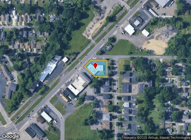
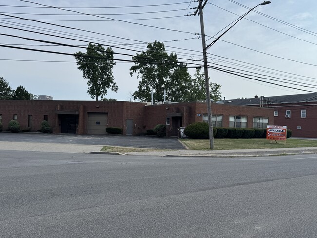
Property Record
661 Erie Ave, North Tonawanda, NY 14120

Current Lease Availabilities
NEARBY LISTINGS FOR SALE OR LEASE
Property Detail
661 Erie Ave
291200-182-014-0001-024-000
COR W SPENCER ST L 10,11 & 12 BL D FL 19 IRREG.SHAPE LOT
Storesoffices
Niagara
X
New York
36063C0361E
24.000
2025
0.56 AC
2024
North
023302
Buffalo/Niagara Falls
8,123 SF
Buffalo-Cheektowaga-Niagara Falls, NY
DEMOGRAPHICS near 661 Erie Ave
1 Mile
3 Mile
5 Mile
2024 Total Population
10,641
67,950
155,721
2029 Population
10,323
67,107
155,164
Pop Growth 2024-2029
(2.99%)
(1.24%)
(0.36%)
Average Age
43
43
42
2024 Total Households
4,938
30,425
66,316
HH Growth 2024-2029
(3.04%)
(1.31%)
(0.39%)
Median Household Inc
$65,835
$70,906
$74,088
Avg Household Size
2.10
2.20
2.20
2024 Avg HH Vehicles
2.00
2.00
2.00
Median Home Value
$175,494
$206,441
$228,771
Median Year Built
1948
1957
1959
Nearby Places
Map Layers
Map Styles
 Street
 Aerial
- Restaurants
- Banks
- Shops
- Fitness
- Groceries
PUBLIC TRANSPORTATION
AIRPORT
Niagara Falls International
DRIVE
WALK
Distance
Niagara Falls International
15 min
7.6 mi
Buffalo Niagara International
DRIVE
WALK
Distance
Buffalo Niagara International
22 min
12.6 mi
Nearby Properties
Address
Land Use
TOTAL SIZE
Lot Size
Zoning
Address
Land Use
TOTAL SIZE
Lot Size
Zoning
5,472 SF
70.10 AC
Address
Land Use
TOTAL SIZE
Lot Size
Zoning
223,916 SF
8.25 AC
R-C
Address
Land Use
TOTAL SIZE
Lot Size
Zoning
4,707 SF
13.60 AC
WD NT
Address
Land Use
TOTAL SIZE
Lot Size
Zoning
11,248 SF
21.70 AC
MFR-5
Address
Land Use
TOTAL SIZE
Lot Size
Zoning
173,303 SF
24.40 AC
R1-2
Address
Land Use
TOTAL SIZE
Lot Size
Zoning
130,412 SF
21.21 AC
Address
Land Use
TOTAL SIZE
Lot Size
Zoning
112,256 SF
38.33 AC
00000
Address
Land Use
TOTAL SIZE
Lot Size
Zoning
96,554 SF
10.90 AC
Address
Land Use
TOTAL SIZE
Lot Size
Zoning
2,474 SF
24.84 AC
Address
Land Use
TOTAL SIZE
Lot Size
Zoning
67,000 SF
6.50 AC
Address
Land Use
TOTAL SIZE
Lot Size
Zoning
270,320 SF
12.20 AC
Address
Land Use
TOTAL SIZE
Lot Size
Zoning
137,878 SF
23.60 AC
R1-2
Address
Land Use
TOTAL SIZE
Lot Size
Zoning
107,490 SF
3.55 AC
Address
Land Use
TOTAL SIZE
Lot Size
Zoning
81,224 SF
0.45 AC
Address
Land Use
TOTAL SIZE
Lot Size
Zoning
33,970 SF
9.70 AC
Address
Land Use
TOTAL SIZE
Lot Size
Zoning
135,140 SF
25.60 AC
Address
Land Use
TOTAL SIZE
Lot Size
Zoning
Address
Land Use
TOTAL SIZE
Lot Size
Zoning
Address
Land Use
TOTAL SIZE
Lot Size
Zoning
97,580 SF
8.43 AC
Address
Land Use
TOTAL SIZE
Lot Size
Zoning
34,655 SF
3.68 AC
Address
Land Use
TOTAL SIZE
Lot Size
Zoning
175,793 SF
27.30 AC
M-1
Address
Land Use
TOTAL SIZE
Lot Size
Zoning
Address
Land Use
TOTAL SIZE
Lot Size
Zoning
Address
Land Use
TOTAL SIZE
Lot Size
Zoning
137,200 SF
3.56 AC
WD
Address
Land Use
TOTAL SIZE
Lot Size
Zoning
28,448 SF
4.30 AC
GB
Address
Land Use
TOTAL SIZE
Lot Size
Zoning
1,323 SF
26.39 AC
R-2
Address
Land Use
TOTAL SIZE
Lot Size
Zoning
96,458 SF
7.94 AC
GB
Address
Land Use
TOTAL SIZE
Lot Size
Zoning
57,000 SF
4.02 AC
Address
Land Use
TOTAL SIZE
Lot Size
Zoning
67,285 SF
6.73 AC
RD
Address
Land Use
TOTAL SIZE
Lot Size
Zoning
47,400 SF
10.03 AC
MS
The World's #1 Commercial Real Estate Marketplace
Connect with us
© 2025 CoStar Group
The information above has been obtained from sources believed reliable. While we do not doubt its accuracy we have not verified it and make no guarantee, warranty or representation about it. It is your responsibility to independently confirm its accuracy and completeness. Any projections, opinions, assumptions, or estimates used are for example only and do not represent the current or future performance of the property. The value of this transaction to you depends on tax and other factors which should be evaluated by your tax, financial, and legal advisors. You and your advisors should conduct a careful, independent investigation of the property to determine to your satisfaction the suitability of the property for your needs.