Property Record
661 Jerico Dr, Mason, MI 48854

Save to a Folder
{{folder.Name}}
{{folder.ListingIds.length}} Properties
{{folder.ListingIds.length}} Property
Create a New Folder
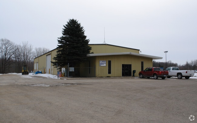
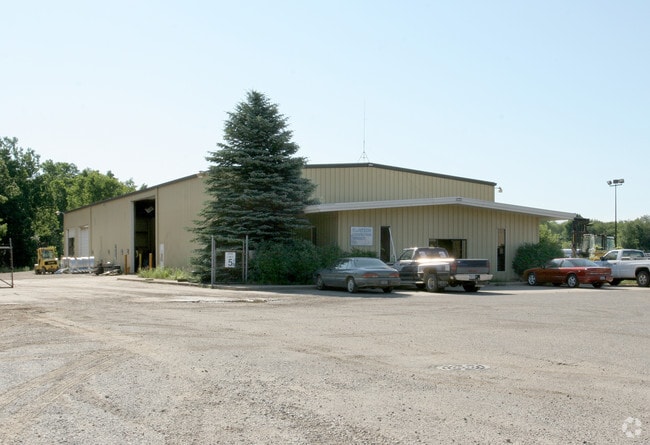
Property Detail
661 Jerico Dr
19-10-05-126-021
COMMENCING AT THE NORTHWEST CORNER OF SECTION 5, S89?55'18E 1616.01 FEET TO THE EAST LINE OF KIM DRIVE (PRIVATE); THENCE
Manufacturinglight
INGHAM
M2
Michigan
B and X Area of moderate flood hazard, usually the area between the limits of the 100-year and 500-year floods.
6.86 AC
2025
Mason/SE Ingham County
2026
West Michigan
006301
Lansing-East Lansing, MI
10,724 SF
NEARBY LISTINGS FOR SALE OR LEASE
DEMOGRAPHICS near 661 Jerico Dr
1 mile
3 mile
5 mile
2025 Total Population
2,129
10,219
25,918
2030 Population
2,138
10,219
25,964
Pop Growth 2025-2030
+ 0.42%
0.00%
+ 0.18%
Average Age
40
41
41
2025 Total Households
830
4,174
10,624
HH Growth 2025-2030
+ 0.24%
(0.05%)
+ 0.26%
Median Household Inc
$83,163
$87,731
$87,492
Avg Household Size
2.30
2.40
2.40
2025 Avg HH Vehicles
2.00
2.00
2.00
Median Home Value
$181,854
$224,436
$219,379
Median Year Built
1990
1976
1976
Nearby Places
Map Layers
Map Styles
 Street
 Aerial
Layers
 Traffic
 Biking
Places
Listings with unknown addresses are not visible on the map
- Restaurants
- Banks
- Shops
- Fitness
- Groceries
PUBLIC TRANSPORTATION
AIRPORT
Capital Region International
Drive
Walk
Distance
Capital Region International
27 min
17.7 mi
Nearby Properties
Address
Land Use
TOTAL SIZE
Lot Size
Zoning
Address
Land Use
TOTAL SIZE
Lot Size
Zoning
146,160 SF
88.98 AC
I-1
Address
Land Use
TOTAL SIZE
Lot Size
Zoning
15,000 SF
Address
Land Use
TOTAL SIZE
Lot Size
Zoning
107,580 SF
Address
Land Use
TOTAL SIZE
Lot Size
Zoning
22,819 SF
63.48 AC
M2
Address
Land Use
TOTAL SIZE
Lot Size
Zoning
269,915 SF
Address
Land Use
TOTAL SIZE
Lot Size
Zoning
32,160 SF
MIXED ZONI
Address
Land Use
TOTAL SIZE
Lot Size
Zoning
16,028 SF
30.69 AC
M2
Address
Land Use
TOTAL SIZE
Lot Size
Zoning
176,921 SF
26.92 AC
C2
Address
Land Use
TOTAL SIZE
Lot Size
Zoning
23,254 SF
1.58 AC
C1
Address
Land Use
TOTAL SIZE
Lot Size
Zoning
145,200 SF
MIXED ZONI
Address
Land Use
TOTAL SIZE
Lot Size
Zoning
5,000 SF
10.74 AC
M1
Address
Land Use
TOTAL SIZE
Lot Size
Zoning
137,084 SF
6.86 AC
M1
Address
Land Use
TOTAL SIZE
Lot Size
Zoning
5,000 SF
16.45 AC
Address
Land Use
TOTAL SIZE
Lot Size
Zoning
18,468 SF
12.26 AC
RM
Address
Land Use
TOTAL SIZE
Lot Size
Zoning
55.34 AC
MH
Address
Land Use
TOTAL SIZE
Lot Size
Zoning
11,520 SF
8.69 AC
RM
Address
Land Use
TOTAL SIZE
Lot Size
Zoning
Address
Land Use
TOTAL SIZE
Lot Size
Zoning
216 SF
6.17 AC
RM
Address
Land Use
TOTAL SIZE
Lot Size
Zoning
15,704 SF
3.41 AC
RM
Address
Land Use
TOTAL SIZE
Lot Size
Zoning
39,176 SF
4.96 AC
C2
Address
Land Use
TOTAL SIZE
Lot Size
Zoning
6,768 SF
228.81 AC
A-1
Address
Land Use
TOTAL SIZE
Lot Size
Zoning
18,468 SF
5.50 AC
RM
Address
Land Use
TOTAL SIZE
Lot Size
Zoning
31.63 AC
MH
Address
Land Use
TOTAL SIZE
Lot Size
Zoning
11,112 SF
10.96 AC
M2
Address
Land Use
TOTAL SIZE
Lot Size
Zoning
300,000 SF
Address
Land Use
TOTAL SIZE
Lot Size
Zoning
34,390 SF
2.38 AC
C2
Address
Land Use
TOTAL SIZE
Lot Size
Zoning
71,901 SF
14.27 AC
C2
Address
Land Use
TOTAL SIZE
Lot Size
Zoning
32,556 SF
6.52 AC
C2
Address
Land Use
TOTAL SIZE
Lot Size
Zoning
64,640 SF
3.42 AC
M1
Address
Land Use
TOTAL SIZE
Lot Size
Zoning
6,745 SF
2.08 AC
C2
The World's #1 Commercial Real Estate Marketplace
Connect with us
© 2026 CoStar Group
The information above has been obtained from sources believed reliable. While we do not doubt its accuracy we have not verified it and make no guarantee, warranty or representation about it. It is your responsibility to independently confirm its accuracy and completeness. Any projections, opinions, assumptions, or estimates used are for example only and do not represent the current or future performance of the property. The value of this transaction to you depends on tax and other factors which should be evaluated by your tax, financial, and legal advisors. You and your advisors should conduct a careful, independent investigation of the property to determine to your satisfaction the suitability of the property for your needs.