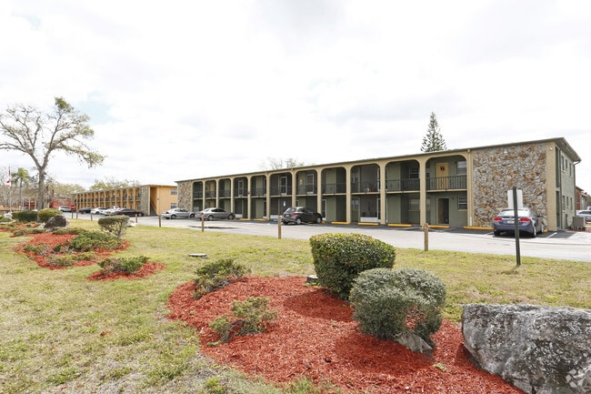
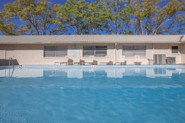
Property Record
6610 Date Palm Blvd, Port Richey, FL 34668

NEARBY LISTINGS FOR SALE OR LEASE
-
-
View all Port Richey listings for sale on LoopNet.com
Property Detail
6610 Date Palm Blvd
28-25-16-0140-00E00-0000
Ridge Crest Gardens
Multifamilydwelling
RIDGE CREST GARDENS PB 12 PG 4 TR C
X
Pasco
12101C0187G
Florida
2024
1.54 AC
2025
Jasmine Estates
031005
Tampa/St Petersburg
24,728 SF
Tampa-St. Petersburg-Clearwater, FL
DEMOGRAPHICS near 6610 Date Palm Blvd
1 Mile
3 Mile
5 Mile
2024 Total Population
11,775
71,336
149,368
2029 Population
13,998
85,483
179,258
Pop Growth 2024-2029
+ 18.88%
+ 19.83%
+ 20.01%
Average Age
41
44
46
2024 Total Households
4,937
31,067
65,843
HH Growth 2024-2029
+ 18.76%
+ 19.84%
+ 20.04%
Median Household Inc
$41,162
$43,348
$46,600
Avg Household Size
2.30
2.20
2.20
2024 Avg HH Vehicles
2.00
2.00
2.00
Median Home Value
$135,588
$144,351
$166,924
Median Year Built
1978
1978
1979
Nearby Places
Map Layers
Map Styles
 Street
 Aerial
- Restaurants
- Banks
- Shops
- Fitness
- Groceries
PUBLIC TRANSPORTATION
AIRPORT
St Pete-Clearwater International
DRIVE
WALK
Distance
St Pete-Clearwater International
56 min
33.0 mi
Tampa International
DRIVE
WALK
Distance
Tampa International
53 min
35.2 mi
Freight Ports
Port of Tampa Bay
DRIVE
WALK
Distance
Port of Tampa Bay
65 min
40.7 mi
Nearby Properties
Address
Land Use
TOTAL SIZE
Lot Size
Zoning
Address
Land Use
TOTAL SIZE
Lot Size
Zoning
395,386 SF
35.63 AC
C2
Address
Land Use
TOTAL SIZE
Lot Size
Zoning
799,241 SF
88.92 AC
PUD
Address
Land Use
TOTAL SIZE
Lot Size
Zoning
248,561 SF
14.17 AC
C
Address
Land Use
TOTAL SIZE
Lot Size
Zoning
351,012 SF
23.51 AC
MF2
Address
Land Use
TOTAL SIZE
Lot Size
Zoning
220,843 SF
35.13 AC
C2
Address
Land Use
TOTAL SIZE
Lot Size
Zoning
416,037 SF
50.65 AC
C1
Address
Land Use
TOTAL SIZE
Lot Size
Zoning
141,740 SF
22.84 AC
PO1
Address
Land Use
TOTAL SIZE
Lot Size
Zoning
149,162 SF
3.10 AC
C
Address
Land Use
TOTAL SIZE
Lot Size
Zoning
122,037 SF
13.83 AC
MF1
Address
Land Use
TOTAL SIZE
Lot Size
Zoning
121,284 SF
10.25 AC
MF1
Address
Land Use
TOTAL SIZE
Lot Size
Zoning
91,660 SF
16.29 AC
C
Address
Land Use
TOTAL SIZE
Lot Size
Zoning
220,045 SF
22.67 AC
C2
Address
Land Use
TOTAL SIZE
Lot Size
Zoning
124,470 SF
5.09 AC
C2
Address
Land Use
TOTAL SIZE
Lot Size
Zoning
309,759 SF
65.19 AC
AC
Address
Land Use
TOTAL SIZE
Lot Size
Zoning
183,139 SF
19.66 AC
C2
Address
Land Use
TOTAL SIZE
Lot Size
Zoning
217,350 SF
11.20 AC
PUD
Address
Land Use
TOTAL SIZE
Lot Size
Zoning
142,856 SF
20 AC
C
Address
Land Use
TOTAL SIZE
Lot Size
Zoning
76,160 SF
6.74 AC
MPUD
Address
Land Use
TOTAL SIZE
Lot Size
Zoning
220,024 SF
25.72 AC
C1
Address
Land Use
TOTAL SIZE
Lot Size
Zoning
86,570 SF
8.06 AC
MF1
Address
Land Use
TOTAL SIZE
Lot Size
Zoning
111,060 SF
9.31 AC
C3
Address
Land Use
TOTAL SIZE
Lot Size
Zoning
137,157 SF
18.59 AC
C2
Address
Land Use
TOTAL SIZE
Lot Size
Zoning
41,156 SF
2.26 AC
C
Address
Land Use
TOTAL SIZE
Lot Size
Zoning
42,059 SF
9.16 AC
C3
Address
Land Use
TOTAL SIZE
Lot Size
Zoning
84,225 SF
5.21 AC
C2
Address
Land Use
TOTAL SIZE
Lot Size
Zoning
85,003 SF
25 AC
R4
Address
Land Use
TOTAL SIZE
Lot Size
Zoning
91,670 SF
3.51 AC
C2
Address
Land Use
TOTAL SIZE
Lot Size
Zoning
81,839 SF
3.33 AC
C2
Address
Land Use
TOTAL SIZE
Lot Size
Zoning
117,549 SF
8.07 AC
C2
Address
Land Use
TOTAL SIZE
Lot Size
Zoning
78,580 SF
21.43 AC
PUD
The World's #1 Commercial Real Estate Marketplace
Connect with us
© 2025 CoStar Group
The information above has been obtained from sources believed reliable. While we do not doubt its accuracy we have not verified it and make no guarantee, warranty or representation about it. It is your responsibility to independently confirm its accuracy and completeness. Any projections, opinions, assumptions, or estimates used are for example only and do not represent the current or future performance of the property. The value of this transaction to you depends on tax and other factors which should be evaluated by your tax, financial, and legal advisors. You and your advisors should conduct a careful, independent investigation of the property to determine to your satisfaction the suitability of the property for your needs.