Property Record
6610 Fairfield Dr, Northwood, OH 43619
Current Lease Availabilities
NEARBY LISTINGS FOR SALE OR LEASE
-
-
-
-
-
-
-
No Photo
-
View all Northwood listings for lease on LoopNet.com
Property Detail
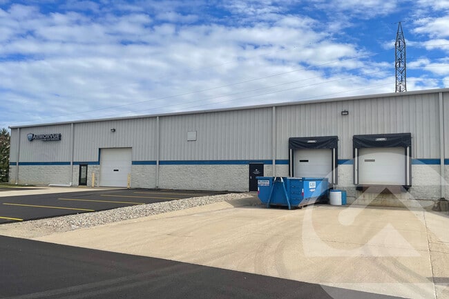
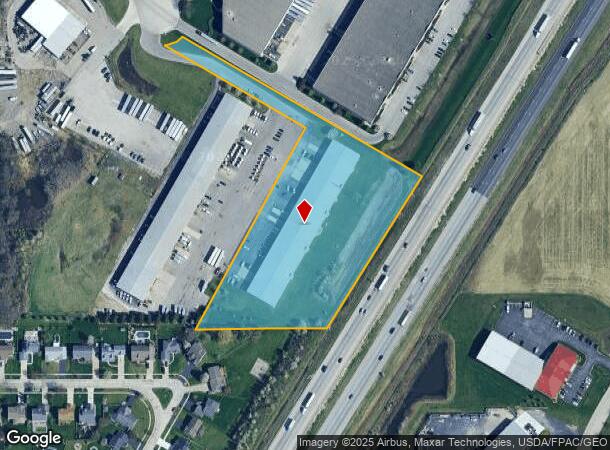
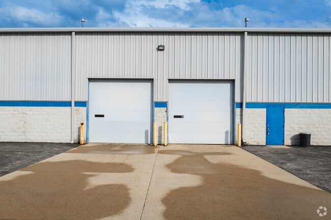
6610 Fairfield Dr
Toledo, OH
Access Point West Plat 2
M51-300-820405001001
ACCESS POINT WEST PLAT 2 LOT 3 EPT CRA 2004-2010 DYE 7 YRS 300820405001101
Warehouse
Wood
X
Ohio
39173C0031D
3
2023
5.37 AC
2024
Perrysburg/Northwood
020100
Toledo
45,900 SF
DEMOGRAPHICS near 6610 Fairfield Dr
1 Mile
3 Mile
5 Mile
2024 Total Population
4,406
47,891
156,250
2029 Population
4,428
48,047
156,813
Pop Growth 2024-2029
+ 0.50%
+ 0.33%
+ 0.36%
Average Age
40
38
39
2024 Total Households
1,821
19,939
67,783
HH Growth 2024-2029
+ 0.49%
+ 0.24%
+ 0.29%
Median Household Inc
$72,142
$48,207
$42,722
Avg Household Size
2.30
2.30
2.20
2024 Avg HH Vehicles
2.00
2.00
1.00
Median Home Value
$150,397
$97,896
$114,361
Median Year Built
1965
1949
1956
Nearby Places
Map Layers
Map Styles
 Street
 Aerial
- Restaurants
- Banks
- Shops
- Fitness
- Groceries
PUBLIC TRANSPORTATION
AIRPORT
Eugene F Kranz Toledo Express
DRIVE
WALK
Distance
Eugene F Kranz Toledo Express
26 min
20.9 mi
Freight Ports
Port of Baltimore
DRIVE
WALK
Distance
Port of Baltimore
1 min
399.6 mi
Nearby Properties
Address
Land Use
TOTAL SIZE
Lot Size
Zoning
Address
Land Use
TOTAL SIZE
Lot Size
Zoning
1,243,593 SF
42.25 AC
10-MX
Address
Land Use
TOTAL SIZE
Lot Size
Zoning
1,081,340 SF
76.95 AC
Address
Land Use
TOTAL SIZE
Lot Size
Zoning
504,154 SF
111.51 AC
Address
Land Use
TOTAL SIZE
Lot Size
Zoning
598,713 SF
59.75 AC
Address
Land Use
TOTAL SIZE
Lot Size
Zoning
245,237 SF
31.72 AC
10-MX
Address
Land Use
TOTAL SIZE
Lot Size
Zoning
496,062 SF
50.37 AC
Address
Land Use
TOTAL SIZE
Lot Size
Zoning
219,265 SF
32.11 AC
Address
Land Use
TOTAL SIZE
Lot Size
Zoning
393,343 SF
62.48 AC
10-IC
Address
Land Use
TOTAL SIZE
Lot Size
Zoning
176,125 SF
21.61 AC
Address
Land Use
TOTAL SIZE
Lot Size
Zoning
174,496 SF
7.30 AC
Address
Land Use
TOTAL SIZE
Lot Size
Zoning
211,050 SF
13.19 AC
Address
Land Use
TOTAL SIZE
Lot Size
Zoning
184,765 SF
12.91 AC
Address
Land Use
TOTAL SIZE
Lot Size
Zoning
486,615 SF
45.39 AC
Address
Land Use
TOTAL SIZE
Lot Size
Zoning
3,840 SF
34.93 AC
Address
Land Use
TOTAL SIZE
Lot Size
Zoning
92,702 SF
4.61 AC
Address
Land Use
TOTAL SIZE
Lot Size
Zoning
94,439 SF
9 AC
10-CO
Address
Land Use
TOTAL SIZE
Lot Size
Zoning
316,351 SF
30.65 AC
10-IC
Address
Land Use
TOTAL SIZE
Lot Size
Zoning
392,037 SF
21.94 AC
Address
Land Use
TOTAL SIZE
Lot Size
Zoning
431,435 SF
13.74 AC
Address
Land Use
TOTAL SIZE
Lot Size
Zoning
170,760 SF
51.98 AC
Address
Land Use
TOTAL SIZE
Lot Size
Zoning
225,918 SF
17.15 AC
Address
Land Use
TOTAL SIZE
Lot Size
Zoning
349,799 SF
51.86 AC
Address
Land Use
TOTAL SIZE
Lot Size
Zoning
69,007 SF
15.93 AC
Address
Land Use
TOTAL SIZE
Lot Size
Zoning
75,770 SF
2.55 AC
Address
Land Use
TOTAL SIZE
Lot Size
Zoning
75,890 SF
19.08 AC
Address
Land Use
TOTAL SIZE
Lot Size
Zoning
228,251 SF
43.08 AC
10-RD6
Address
Land Use
TOTAL SIZE
Lot Size
Zoning
100,531 SF
3.07 AC
Address
Land Use
TOTAL SIZE
Lot Size
Zoning
152,163 SF
2.49 AC
Address
Land Use
TOTAL SIZE
Lot Size
Zoning
351,114 SF
26.32 AC
10-MX
Address
Land Use
TOTAL SIZE
Lot Size
Zoning
46,528 SF
1.75 AC
The World's #1 Commercial Real Estate Marketplace
Connect with us
© 2025 CoStar Group
The information above has been obtained from sources believed reliable. While we do not doubt its accuracy we have not verified it and make no guarantee, warranty or representation about it. It is your responsibility to independently confirm its accuracy and completeness. Any projections, opinions, assumptions, or estimates used are for example only and do not represent the current or future performance of the property. The value of this transaction to you depends on tax and other factors which should be evaluated by your tax, financial, and legal advisors. You and your advisors should conduct a careful, independent investigation of the property to determine to your satisfaction the suitability of the property for your needs.