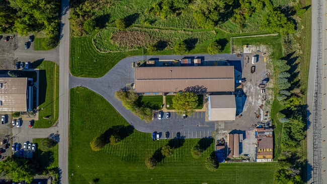
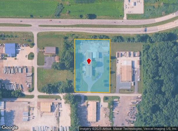
Property Record
6610 Shepherd Ave, Portage, IN 46368

Current Lease Availabilities
NEARBY LISTINGS FOR SALE OR LEASE
Property Detail
6610 Shepherd Ave
64-03-31-154-002.000-016
PARC W359 E2108.24 N530.10 S703.28 NW TIF 31-37-6 4.369A
Warehouse
Porter
X
Indiana
18127C0106E
4.36 AC
2024
Porter County
2024
Chicago
050407
Chicago-Naperville-Elgin, IL-IN-WI
18,064 SF
DEMOGRAPHICS near 6610 Shepherd Ave
1 Mile
3 Mile
5 Mile
2024 Total Population
151
18,362
62,097
2029 Population
159
18,911
63,559
Pop Growth 2024-2029
+ 5.30%
+ 2.99%
+ 2.35%
Average Age
42
41
40
2024 Total Households
64
7,211
24,515
HH Growth 2024-2029
+ 6.25%
+ 3.08%
+ 2.38%
Median Household Inc
$53,750
$81,083
$69,069
Avg Household Size
2.40
2.50
2.50
2024 Avg HH Vehicles
2.00
2.00
2.00
Median Home Value
$156,249
$233,440
$197,762
Median Year Built
1971
1979
1975
Nearby Places
- Restaurants
- Banks
- Shops
- Fitness
- Groceries
PUBLIC TRANSPORTATION
COMMUTER RAIL
Ogden Dunes (Portage) Station (South Shore Line - Northern Indiana Commuter Transportation District (South Shore Line))
DRIVE
WALK
Distance
Ogden Dunes (Portage) Station (South Shore Line - Northern Indiana Commuter Transportation District (South Shore Line))
4 min
1.7 mi
Dune Park (Chesterton) Station (South Shore Line - Northern Indiana Commuter Transportation District (South Shore Line))
DRIVE
WALK
Distance
Dune Park (Chesterton) Station (South Shore Line - Northern Indiana Commuter Transportation District (South Shore Line))
11 min
6.3 mi
Freight Ports
Port Milwaukee
DRIVE
WALK
Distance
Port Milwaukee
160 min
126.6 mi
Nearby Properties
Address
Land Use
TOTAL SIZE
Lot Size
Zoning
Address
Land Use
TOTAL SIZE
Lot Size
Zoning
5,092,064 SF
0.06 AC
Address
Land Use
TOTAL SIZE
Lot Size
Zoning
511,056 SF
131 SF
Address
Land Use
TOTAL SIZE
Lot Size
Zoning
3,430,063 SF
0.04 AC
Address
Land Use
TOTAL SIZE
Lot Size
Zoning
2,305,884 SF
0.03 AC
Address
Land Use
TOTAL SIZE
Lot Size
Zoning
567,109 SF
131 SF
Address
Land Use
TOTAL SIZE
Lot Size
Zoning
400,440 SF
87 SF
Address
Land Use
TOTAL SIZE
Lot Size
Zoning
533,172 SF
Address
Land Use
TOTAL SIZE
Lot Size
Zoning
789,622 SF
0.02 AC
Address
Land Use
TOTAL SIZE
Lot Size
Zoning
199,296 SF
87 SF
Address
Land Use
TOTAL SIZE
Lot Size
Zoning
204,400 SF
Address
Land Use
TOTAL SIZE
Lot Size
Zoning
243,963 SF
Address
Land Use
TOTAL SIZE
Lot Size
Zoning
78,620 SF
87 SF
Address
Land Use
TOTAL SIZE
Lot Size
Zoning
233,491 SF
174 SF
Address
Land Use
TOTAL SIZE
Lot Size
Zoning
73,376 SF
44 SF
Address
Land Use
TOTAL SIZE
Lot Size
Zoning
116,310 SF
131 SF
Address
Land Use
TOTAL SIZE
Lot Size
Zoning
67,925 SF
2.97 AC
Address
Land Use
TOTAL SIZE
Lot Size
Zoning
478,084 SF
0.01 AC
Address
Land Use
TOTAL SIZE
Lot Size
Zoning
70,454 SF
1.14 AC
Address
Land Use
TOTAL SIZE
Lot Size
Zoning
70,454 SF
1.20 AC
Address
Land Use
TOTAL SIZE
Lot Size
Zoning
147,024 SF
44 SF
Address
Land Use
TOTAL SIZE
Lot Size
Zoning
61,561 SF
3.71 AC
Address
Land Use
TOTAL SIZE
Lot Size
Zoning
216,590 SF
Address
Land Use
TOTAL SIZE
Lot Size
Zoning
159,933 SF
0.01 AC
Address
Land Use
TOTAL SIZE
Lot Size
Zoning
157,920 SF
44 SF
Address
Land Use
TOTAL SIZE
Lot Size
Zoning
164,640 SF
44 SF
Address
Land Use
TOTAL SIZE
Lot Size
Zoning
22,652 SF
16.10 AC
Address
Land Use
TOTAL SIZE
Lot Size
Zoning
174,960 SF
Address
Land Use
TOTAL SIZE
Lot Size
Zoning
73,528 SF
44 SF
Address
Land Use
TOTAL SIZE
Lot Size
Zoning
122,175 SF
44 SF
Address
Land Use
TOTAL SIZE
Lot Size
Zoning
35,750 SF
44 SF
The World's #1 Commercial Real Estate Marketplace
Connect with us
© 2025 CoStar Group
The information above has been obtained from sources believed reliable. While we do not doubt its accuracy we have not verified it and make no guarantee, warranty or representation about it. It is your responsibility to independently confirm its accuracy and completeness. Any projections, opinions, assumptions, or estimates used are for example only and do not represent the current or future performance of the property. The value of this transaction to you depends on tax and other factors which should be evaluated by your tax, financial, and legal advisors. You and your advisors should conduct a careful, independent investigation of the property to determine to your satisfaction the suitability of the property for your needs.