Property Record
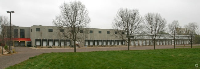
6610 W Broadway Ave, Minneapolis, MN 55428


NEARBY LISTINGS FOR SALE OR LEASE
Property Detail
6610 W Broadway Ave
Minneapolis-St. Paul-Bloomington, MN-WI
Unplatted 32 119 21
32-119-21-24-0024
UNPLATTED 32 119 21 BEG AT A PT ON W LINE OF E 1/2 OF NW 1/4 DIST 1710.4 FT S FROM NW 1/4 THOF TH S 370 FT TH E 466 FT TH S 293.1 FT TH W 108 FT TH S 154.05 FT TH E 385 T IRREGULAR
Industrialgeneral
Hennepin
X
Minnesota
27053C0203F
19.26 AC
2024
Northwest
2024
Minneapolis/St Paul
026807
DEMOGRAPHICS near 6610 W Broadway Ave
1 Mile
3 Mile
5 Mile
2024 Total Population
13,921
92,671
251,833
2029 Population
13,582
90,801
247,092
Pop Growth 2024-2029
(2.44%)
(2.02%)
(1.88%)
Average Age
37
38
39
2024 Total Households
5,173
33,804
94,521
HH Growth 2024-2029
(2.61%)
(2.20%)
(2.05%)
Median Household Inc
$53,697
$67,578
$79,633
Avg Household Size
2.60
2.60
2.60
2024 Avg HH Vehicles
2.00
2.00
2.00
Median Home Value
$234,468
$250,431
$276,718
Median Year Built
1970
1971
1974
Nearby Places
Map Layers
Map Styles
 Street
 Aerial
- Restaurants
- Banks
- Shops
- Fitness
- Groceries
PUBLIC TRANSPORTATION
COMMUTER RAIL
Fridley Station (Northstar Corridor - Northstar Commuter Rail)
DRIVE
WALK
Distance
Fridley Station (Northstar Corridor - Northstar Commuter Rail)
12 min
7.2 mi
Target Field Station (Northstar Corridor - Northstar Commuter Rail)
DRIVE
WALK
Distance
Target Field Station (Northstar Corridor - Northstar Commuter Rail)
19 min
9.0 mi
AIRPORT
Minneapolis-St Paul International/Wold-Chamberlain
DRIVE
WALK
Distance
Minneapolis-St Paul International/Wold-Chamberlain
35 min
24.0 mi
Freight Ports
Port Milwaukee
DRIVE
WALK
Distance
Port Milwaukee
388 min
350.5 mi
Nearby Properties
Address
Land Use
TOTAL SIZE
Lot Size
Zoning
Address
Land Use
TOTAL SIZE
Lot Size
Zoning
17.26 AC
Address
Land Use
TOTAL SIZE
Lot Size
Zoning
36.46 AC
Address
Land Use
TOTAL SIZE
Lot Size
Zoning
26.57 AC
Address
Land Use
TOTAL SIZE
Lot Size
Zoning
Address
Land Use
TOTAL SIZE
Lot Size
Zoning
26.73 AC
Address
Land Use
TOTAL SIZE
Lot Size
Zoning
409,456 SF
12.40 AC
Address
Land Use
TOTAL SIZE
Lot Size
Zoning
196,970 SF
15.63 AC
Address
Land Use
TOTAL SIZE
Lot Size
Zoning
351,351 SF
17.98 AC
Address
Land Use
TOTAL SIZE
Lot Size
Zoning
20.48 AC
Address
Land Use
TOTAL SIZE
Lot Size
Zoning
19.10 AC
Address
Land Use
TOTAL SIZE
Lot Size
Zoning
Address
Land Use
TOTAL SIZE
Lot Size
Zoning
35.38 AC
Address
Land Use
TOTAL SIZE
Lot Size
Zoning
18.59 AC
Address
Land Use
TOTAL SIZE
Lot Size
Zoning
Address
Land Use
TOTAL SIZE
Lot Size
Zoning
12.03 AC
Address
Land Use
TOTAL SIZE
Lot Size
Zoning
11.20 AC
Address
Land Use
TOTAL SIZE
Lot Size
Zoning
Address
Land Use
TOTAL SIZE
Lot Size
Zoning
26.26 AC
Address
Land Use
TOTAL SIZE
Lot Size
Zoning
Address
Land Use
TOTAL SIZE
Lot Size
Zoning
4.34 AC
Address
Land Use
TOTAL SIZE
Lot Size
Zoning
Address
Land Use
TOTAL SIZE
Lot Size
Zoning
Address
Land Use
TOTAL SIZE
Lot Size
Zoning
Address
Land Use
TOTAL SIZE
Lot Size
Zoning
15.94 AC
Address
Land Use
TOTAL SIZE
Lot Size
Zoning
21.10 AC
Address
Land Use
TOTAL SIZE
Lot Size
Zoning
13.07 AC
Address
Land Use
TOTAL SIZE
Lot Size
Zoning
35,762 SF
4.48 AC
Address
Land Use
TOTAL SIZE
Lot Size
Zoning
18.26 AC
Address
Land Use
TOTAL SIZE
Lot Size
Zoning
14.87 AC
Address
Land Use
TOTAL SIZE
Lot Size
Zoning
The World's #1 Commercial Real Estate Marketplace
Connect with us
© 2026 CoStar Group
The information above has been obtained from sources believed reliable. While we do not doubt its accuracy we have not verified it and make no guarantee, warranty or representation about it. It is your responsibility to independently confirm its accuracy and completeness. Any projections, opinions, assumptions, or estimates used are for example only and do not represent the current or future performance of the property. The value of this transaction to you depends on tax and other factors which should be evaluated by your tax, financial, and legal advisors. You and your advisors should conduct a careful, independent investigation of the property to determine to your satisfaction the suitability of the property for your needs.