Property Record
6616 35Th Ave Ne, Tulalip, WA 98271
Current Lease Availabilities
NEARBY LISTINGS FOR SALE OR LEASE
Property Detail
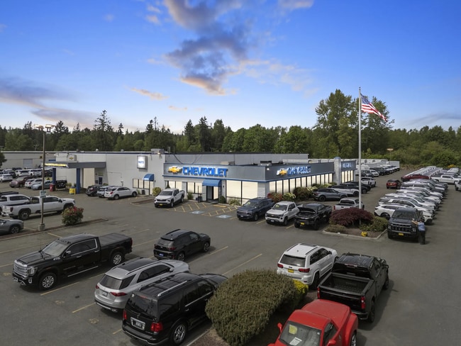
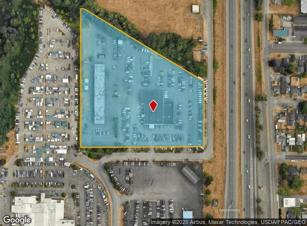
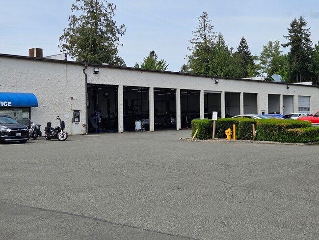
6616 35Th Ave Ne
Seattle-Tacoma-Bellevue, WA
Marysville
300529-004-007-00
SEC 29 TWP 30 RGE 05 TH PTN NE1/4 SE1/4 LY NLY MARYSVILLE -TULALIP RD DESC AS E 760FT AS MEAS FR E SEC LN FDP-COM E1/4 COR SEC 29 POB TH S89*30 00W 315.78FT M/L TO WLY R/W LN PSH 1 TH S00*30 00E ALG SD WLY R/W LN 361.7FT TH N61*26 43W 749.56FT M/L TA
Vehiclerentalsvehiclesales
Snohomish
X
Washington
53061C0716G
7
2024
8.04 AC
2025
N Snohomish County
940001
Seattle/Puget Sound
42,519 SF
DEMOGRAPHICS near 6616 35Th Ave Ne
1 Mile
3 Mile
5 Mile
2024 Total Population
7,214
48,512
103,650
2029 Population
7,574
50,758
108,580
Pop Growth 2024-2029
+ 4.99%
+ 4.63%
+ 4.76%
Average Age
38
39
39
2024 Total Households
2,780
17,336
37,264
HH Growth 2024-2029
+ 5.14%
+ 4.74%
+ 4.83%
Median Household Inc
$59,180
$88,569
$91,962
Avg Household Size
2.50
2.70
2.70
2024 Avg HH Vehicles
2.00
2.00
2.00
Median Home Value
$377,225
$461,235
$482,420
Median Year Built
1973
1988
1987
Nearby Places
Map Layers
Map Styles
 Street
 Aerial
- Restaurants
- Banks
- Shops
- Fitness
- Groceries
PUBLIC TRANSPORTATION
COMMUTER RAIL
Everett Station (Sounder South Line - Central Puget Sound Regional Transit Authority Rail (Link Light Rail/Sounder))
DRIVE
WALK
Distance
Everett Station (Sounder South Line - Central Puget Sound Regional Transit Authority Rail (Link Light Rail/Sounder))
11 min
6.4 mi
AIRPORT
Seattle Paine Field International
DRIVE
WALK
Distance
Seattle Paine Field International
22 min
14.7 mi
Freight Ports
Port of Everett
DRIVE
WALK
Distance
Port of Everett
12 min
7.1 mi
Nearby Properties
Address
Land Use
TOTAL SIZE
Lot Size
Zoning
Address
Land Use
TOTAL SIZE
Lot Size
Zoning
113,927 SF
576.83 AC
TRIBES
Address
Land Use
TOTAL SIZE
Lot Size
Zoning
234,485 SF
16.71 AC
HI
Address
Land Use
TOTAL SIZE
Lot Size
Zoning
102,364 SF
0.19 AC
GC
Address
Land Use
TOTAL SIZE
Lot Size
Zoning
126,200 SF
8.34 AC
R18 MFM
Address
Land Use
TOTAL SIZE
Lot Size
Zoning
174,661 SF
12.98 AC
CB
Address
Land Use
TOTAL SIZE
Lot Size
Zoning
182,983 SF
9.41 AC
DC
Address
Land Use
TOTAL SIZE
Lot Size
Zoning
111,797 SF
9.85 AC
CB
Address
Land Use
TOTAL SIZE
Lot Size
Zoning
17.20 AC
R18 MFM
Address
Land Use
TOTAL SIZE
Lot Size
Zoning
86,495 SF
28.76 AC
R-5
Address
Land Use
TOTAL SIZE
Lot Size
Zoning
128,983 SF
7.64 AC
R12 MFL
Address
Land Use
TOTAL SIZE
Lot Size
Zoning
110,890 SF
7.44 AC
R28 MFH
Address
Land Use
TOTAL SIZE
Lot Size
Zoning
56,434 SF
4.28 AC
R4.5 SFM
Address
Land Use
TOTAL SIZE
Lot Size
Zoning
82,169 SF
53.54 AC
HI
Address
Land Use
TOTAL SIZE
Lot Size
Zoning
50,608 SF
6.07 AC
R18 MFM
Address
Land Use
TOTAL SIZE
Lot Size
Zoning
111.34 AC
TRIBES
Address
Land Use
TOTAL SIZE
Lot Size
Zoning
64,771 SF
3.07 AC
CB
Address
Land Use
TOTAL SIZE
Lot Size
Zoning
81,026 SF
3.47 AC
GC
Address
Land Use
TOTAL SIZE
Lot Size
Zoning
40,493 SF
3.16 AC
MU
Address
Land Use
TOTAL SIZE
Lot Size
Zoning
88,409 SF
3.90 AC
R6.5 SFH
Address
Land Use
TOTAL SIZE
Lot Size
Zoning
51,919 SF
4.74 AC
R18 MFM
Address
Land Use
TOTAL SIZE
Lot Size
Zoning
76,749 SF
1.35 AC
CB
Address
Land Use
TOTAL SIZE
Lot Size
Zoning
47,664 SF
3.49 AC
R18 MFM
Address
Land Use
TOTAL SIZE
Lot Size
Zoning
46,692 SF
4.85 AC
R-5
Address
Land Use
TOTAL SIZE
Lot Size
Zoning
2,880 SF
56.66 AC
GC
Address
Land Use
TOTAL SIZE
Lot Size
Zoning
58,551 SF
2.08 AC
R6.5 SFH
Address
Land Use
TOTAL SIZE
Lot Size
Zoning
35,046 SF
2.67 AC
MU
Address
Land Use
TOTAL SIZE
Lot Size
Zoning
46,276 SF
2.64 AC
R18 MFM
Address
Land Use
TOTAL SIZE
Lot Size
Zoning
24.29 AC
R12 MFL
Address
Land Use
TOTAL SIZE
Lot Size
Zoning
50,022 SF
4.73 AC
CB
The World's #1 Commercial Real Estate Marketplace
Connect with us
© 2025 CoStar Group
The information above has been obtained from sources believed reliable. While we do not doubt its accuracy we have not verified it and make no guarantee, warranty or representation about it. It is your responsibility to independently confirm its accuracy and completeness. Any projections, opinions, assumptions, or estimates used are for example only and do not represent the current or future performance of the property. The value of this transaction to you depends on tax and other factors which should be evaluated by your tax, financial, and legal advisors. You and your advisors should conduct a careful, independent investigation of the property to determine to your satisfaction the suitability of the property for your needs.