Property Record
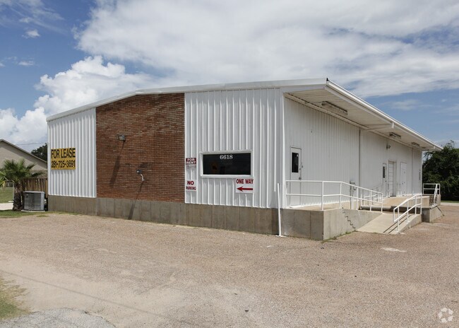
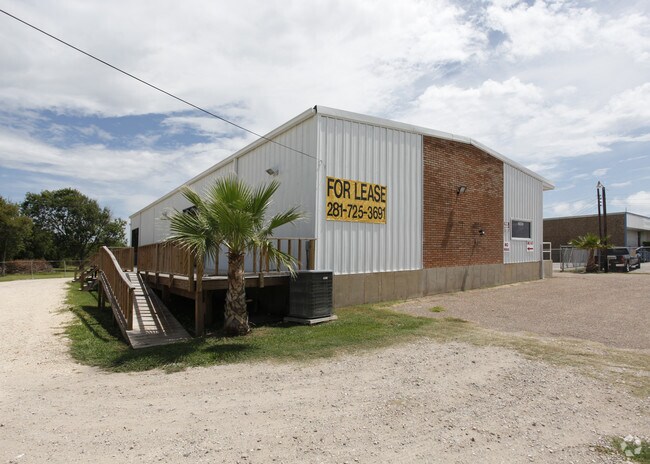
6618 E Highway 332, Freeport, TX 77541

Property Detail
6618 E Highway 332
2113-0154-000
B C I C DIV 13 LOT 244F (A0049 A CALVIT & A0099 E MITCHELL) ACRES 0.52
Commercialnec
BRAZORIA
0620
Texas
B and X Area of moderate flood hazard, usually the area between the limits of the 100-year and 500-year floods.
244f
2024
0.52 AC
2025
Far South
6642001435
Houston
4,700 SF
Houston-Pasadena-The Woodlands, TX
NEARBY LISTINGS FOR SALE OR LEASE
DEMOGRAPHICS near 6618 E Highway 332
1 mile
3 mile
5 mile
2025 Total Population
139
18,356
50,593
2030 Population
158
20,701
56,426
Pop Growth 2025-2030
+ 13.67%
+ 12.78%
+ 11.53%
Average Age
40
36
37
2025 Total Households
56
6,864
18,793
HH Growth 2025-2030
+ 14.29%
+ 13.40%
+ 11.99%
Median Household Inc
$36,071
$53,389
$66,062
Avg Household Size
2.50
2.70
2.70
2025 Avg HH Vehicles
2.00
2.00
2.00
Median Home Value
$112,500
$165,319
$215,816
Median Year Built
1979
1981
1981
Nearby Places
Map Layers
Map Styles
 Street
 Aerial
Transit
 Traffic
 Biking
Places
Listings with unknown addresses are not visible on the map
- Restaurants
- Banks
- Shops
- Fitness
- Groceries
Nearby Properties
Address
Land Use
TOTAL SIZE
Lot Size
Zoning
Address
Land Use
TOTAL SIZE
Lot Size
Zoning
Address
Land Use
TOTAL SIZE
Lot Size
Zoning
Address
Land Use
TOTAL SIZE
Lot Size
Zoning
Address
Land Use
TOTAL SIZE
Lot Size
Zoning
35.50 AC
8680
Address
Land Use
TOTAL SIZE
Lot Size
Zoning
Address
Land Use
TOTAL SIZE
Lot Size
Zoning
Address
Land Use
TOTAL SIZE
Lot Size
Zoning
Address
Land Use
TOTAL SIZE
Lot Size
Zoning
Address
Land Use
TOTAL SIZE
Lot Size
Zoning
320,260 SF
31.88 AC
Address
Land Use
TOTAL SIZE
Lot Size
Zoning
33.09 AC
0050
Address
Land Use
TOTAL SIZE
Lot Size
Zoning
61.70 AC
Address
Land Use
TOTAL SIZE
Lot Size
Zoning
Address
Land Use
TOTAL SIZE
Lot Size
Zoning
Address
Land Use
TOTAL SIZE
Lot Size
Zoning
Address
Land Use
TOTAL SIZE
Lot Size
Zoning
Address
Land Use
TOTAL SIZE
Lot Size
Zoning
242.03 AC
0275
Address
Land Use
TOTAL SIZE
Lot Size
Zoning
Address
Land Use
TOTAL SIZE
Lot Size
Zoning
200,711 SF
9.88 AC
0041
Address
Land Use
TOTAL SIZE
Lot Size
Zoning
4.27 AC
0170
Address
Land Use
TOTAL SIZE
Lot Size
Zoning
70,468 SF
15.84 AC
0146A
Address
Land Use
TOTAL SIZE
Lot Size
Zoning
188,497 SF
14.79 AC
1135
Address
Land Use
TOTAL SIZE
Lot Size
Zoning
145,222 SF
7.25 AC
0109
Address
Land Use
TOTAL SIZE
Lot Size
Zoning
216,802 SF
11.49 AC
Address
Land Use
TOTAL SIZE
Lot Size
Zoning
Address
Land Use
TOTAL SIZE
Lot Size
Zoning
75.99 AC
0410
Address
Land Use
TOTAL SIZE
Lot Size
Zoning
Address
Land Use
TOTAL SIZE
Lot Size
Zoning
197,319 SF
9.94 AC
Address
Land Use
TOTAL SIZE
Lot Size
Zoning
Address
Land Use
TOTAL SIZE
Lot Size
Zoning
24.81 AC
0031
Address
Land Use
TOTAL SIZE
Lot Size
Zoning
48,773 SF
The World's #1 Commercial Real Estate Marketplace
Connect with us
© 2026 CoStar Group
The information above has been obtained from sources believed reliable. While we do not doubt its accuracy we have not verified it and make no guarantee, warranty or representation about it. It is your responsibility to independently confirm its accuracy and completeness. Any projections, opinions, assumptions, or estimates used are for example only and do not represent the current or future performance of the property. The value of this transaction to you depends on tax and other factors which should be evaluated by your tax, financial, and legal advisors. You and your advisors should conduct a careful, independent investigation of the property to determine to your satisfaction the suitability of the property for your needs.