Property Record
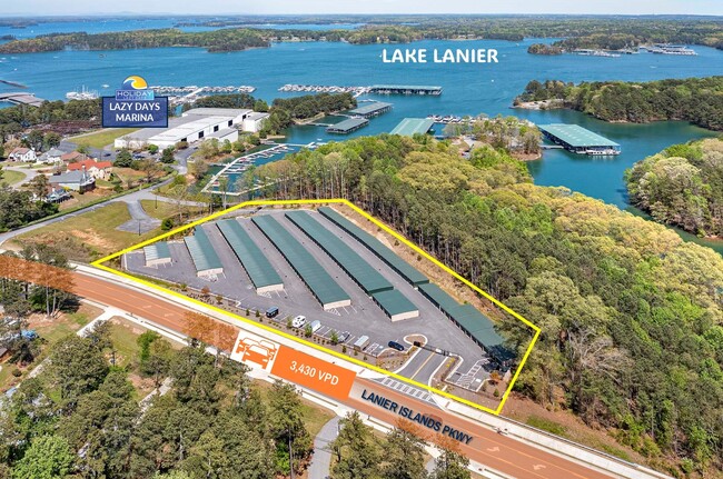
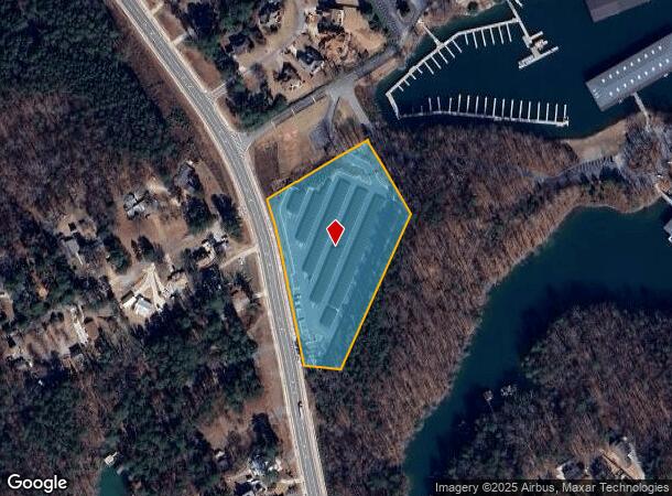
6619 Lanier Islands Pky, Buford, GA 30518
NEARBY LISTINGS FOR SALE OR LEASE
Property Detail
6619 Lanier Islands Pky
07-00355-02-002
Elizabeth Pass Estate
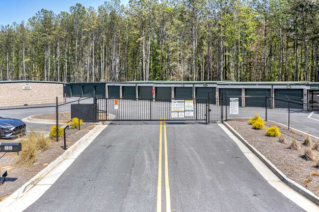
Publicstorage
HOLIDAY ROAD
A
Hall
13139C0275G
Georgia
2025
3.85 AC
2025
Gainesville/Hall County
001502
Atlanta
4,100 SF
Gainesville, GA
DEMOGRAPHICS near 6619 Lanier Islands Pky
1 Mile
3 Mile
5 Mile
2024 Total Population
1,019
13,693
66,364
2029 Population
1,128
14,847
71,884
Pop Growth 2024-2029
+ 10.70%
+ 8.43%
+ 8.32%
Average Age
47
41
38
2024 Total Households
408
4,847
22,703
HH Growth 2024-2029
+ 10.54%
+ 8.60%
+ 8.62%
Median Household Inc
$70,609
$87,418
$80,802
Avg Household Size
2.50
2.80
2.90
2024 Avg HH Vehicles
2.00
2.00
2.00
Median Home Value
$418,235
$349,519
$328,827
Median Year Built
1992
1998
1999
Nearby Places
Map Layers
Map Styles
 Street
 Aerial
- Restaurants
- Banks
- Shops
- Fitness
- Groceries
SALE & LEASE HISTORY
LISTING DATE
SALE/LEASE

Apr 18, 2024
For Sale
Nearby Properties
Address
Land Use
TOTAL SIZE
Lot Size
Zoning
Address
Land Use
TOTAL SIZE
Lot Size
Zoning
285,000 SF
97.06 AC
M-I
Address
Land Use
TOTAL SIZE
Lot Size
Zoning
815,563 SF
58.80 AC
M-I
Address
Land Use
TOTAL SIZE
Lot Size
Zoning
213,532 SF
44.32 AC
M-I
Address
Land Use
TOTAL SIZE
Lot Size
Zoning
224,093 SF
33.94 AC
M-I
Address
Land Use
TOTAL SIZE
Lot Size
Zoning
113,271 SF
78.32 AC
C2
Address
Land Use
TOTAL SIZE
Lot Size
Zoning
264,600 SF
10.27 AC
M1
Address
Land Use
TOTAL SIZE
Lot Size
Zoning
641,180 SF
57.04 AC
M1
Address
Land Use
TOTAL SIZE
Lot Size
Zoning
143,000 SF
41.30 AC
M-I
Address
Land Use
TOTAL SIZE
Lot Size
Zoning
274,018 SF
25.57 AC
M1
Address
Land Use
TOTAL SIZE
Lot Size
Zoning
458,256 SF
26.39 AC
M-I
Address
Land Use
TOTAL SIZE
Lot Size
Zoning
261,368 SF
5.80 AC
M-I
Address
Land Use
TOTAL SIZE
Lot Size
Zoning
225,851 SF
34.35 AC
R75
Address
Land Use
TOTAL SIZE
Lot Size
Zoning
151,330 SF
19.30 AC
RM
Address
Land Use
TOTAL SIZE
Lot Size
Zoning
139,430 SF
35.40 AC
P
Address
Land Use
TOTAL SIZE
Lot Size
Zoning
73,319 SF
17.43 AC
P
Address
Land Use
TOTAL SIZE
Lot Size
Zoning
303,526 SF
19.77 AC
M1
Address
Land Use
TOTAL SIZE
Lot Size
Zoning
114,261 SF
93.99 AC
P
Address
Land Use
TOTAL SIZE
Lot Size
Zoning
250,444 SF
32.04 AC
M1
Address
Land Use
TOTAL SIZE
Lot Size
Zoning
18,408 SF
15.50 AC
L-I
Address
Land Use
TOTAL SIZE
Lot Size
Zoning
96.39 AC
M1
Address
Land Use
TOTAL SIZE
Lot Size
Zoning
295,548 SF
30 AC
M1
Address
Land Use
TOTAL SIZE
Lot Size
Zoning
68,291 SF
13.82 AC
P
Address
Land Use
TOTAL SIZE
Lot Size
Zoning
88,250 SF
2.05 AC
V-C
Address
Land Use
TOTAL SIZE
Lot Size
Zoning
38,000 SF
5.40 AC
M1
Address
Land Use
TOTAL SIZE
Lot Size
Zoning
52,146 SF
0.58 AC
C2
Address
Land Use
TOTAL SIZE
Lot Size
Zoning
34.57 AC
R75
Address
Land Use
TOTAL SIZE
Lot Size
Zoning
31,030 SF
25.52 AC
M1
Address
Land Use
TOTAL SIZE
Lot Size
Zoning
34,560 SF
5.07 AC
M-I
Address
Land Use
TOTAL SIZE
Lot Size
Zoning
81,936 SF
12.29 AC
C2
Address
Land Use
TOTAL SIZE
Lot Size
Zoning
81,813 SF
4.19 AC
M1
The World's #1 Commercial Real Estate Marketplace
Connect with us
© 2025 CoStar Group
The information above has been obtained from sources believed reliable. While we do not doubt its accuracy we have not verified it and make no guarantee, warranty or representation about it. It is your responsibility to independently confirm its accuracy and completeness. Any projections, opinions, assumptions, or estimates used are for example only and do not represent the current or future performance of the property. The value of this transaction to you depends on tax and other factors which should be evaluated by your tax, financial, and legal advisors. You and your advisors should conduct a careful, independent investigation of the property to determine to your satisfaction the suitability of the property for your needs.