No Photo
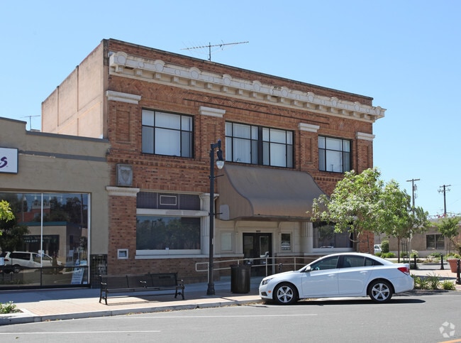
Property Record
6620 3Rd St, Riverbank, CA 95367


NEARBY LISTINGS FOR SALE OR LEASE
-
-
View all Riverbank listings for lease on LoopNet.com
Property Detail
6620 3Rd St
Modesto, CA
Riverbank
132-12-01
RIVERBANK BLOCK 23 LOTS 30 & 31
Officebuilding
Stanislaus
X
California
06077C0835F
30,31
2025
0.14 AC
2025
Modesto
000301
Stockton/Modesto
11,226 SF
DEMOGRAPHICS near 6620 3Rd St
1 Mile
3 Mile
5 Mile
2024 Total Population
12,148
29,205
111,592
2029 Population
12,100
29,213
112,001
Pop Growth 2024-2029
(0.40%)
+ 0.03%
+ 0.37%
Average Age
36
36
38
2024 Total Households
3,566
8,775
37,422
HH Growth 2024-2029
(0.42%)
+ 0.02%
+ 0.34%
Median Household Inc
$65,673
$86,615
$88,345
Avg Household Size
3.40
3.30
2.90
2024 Avg HH Vehicles
2.00
2.00
2.00
Median Home Value
$367,061
$427,041
$437,819
Median Year Built
1983
1992
1985
Nearby Places
Map Layers
Map Styles
 Street
 Aerial
- Restaurants
- Banks
- Shops
- Fitness
- Groceries
PUBLIC TRANSPORTATION
COMMUTER RAIL
DRIVE
WALK
Distance
10 min
5.9 mi
AIRPORT
Stockton Metro
DRIVE
WALK
Distance
Stockton Metro
41 min
27.7 mi
Freight Ports
Port of Stockton
DRIVE
WALK
Distance
Port of Stockton
49 min
36.1 mi
SALE & LEASE HISTORY
LISTING DATE
SALE/LEASE

Oct 16, 2023
For Lease
Oct 16, 2018
For Lease
Jul 12, 2019
For Sale
Nearby Properties
Address
Land Use
TOTAL SIZE
Lot Size
Zoning
Address
Land Use
TOTAL SIZE
Lot Size
Zoning
15.68 AC
RIVPD
Address
Land Use
TOTAL SIZE
Lot Size
Zoning
186,665 SF
10.22 AC
Address
Land Use
TOTAL SIZE
Lot Size
Zoning
123,575 SF
10 AC
PC
Address
Land Use
TOTAL SIZE
Lot Size
Zoning
72,338 SF
5.98 AC
RIVC1
Address
Land Use
TOTAL SIZE
Lot Size
Zoning
140,669 SF
10.96 AC
PC
Address
Land Use
TOTAL SIZE
Lot Size
Zoning
77,578 SF
7.93 AC
Address
Land Use
TOTAL SIZE
Lot Size
Zoning
83,987 SF
4.59 AC
RIVR3
Address
Land Use
TOTAL SIZE
Lot Size
Zoning
88,274 SF
6.32 AC
PC
Address
Land Use
TOTAL SIZE
Lot Size
Zoning
28,560 SF
9.62 AC
Address
Land Use
TOTAL SIZE
Lot Size
Zoning
85,218 SF
3.51 AC
Address
Land Use
TOTAL SIZE
Lot Size
Zoning
57,760 SF
4.89 AC
PC
Address
Land Use
TOTAL SIZE
Lot Size
Zoning
465,061 SF
26.66 AC
CERM1
Address
Land Use
TOTAL SIZE
Lot Size
Zoning
369.73 AC
Address
Land Use
TOTAL SIZE
Lot Size
Zoning
201,657 SF
8.53 AC
Address
Land Use
TOTAL SIZE
Lot Size
Zoning
42,000 SF
2.84 AC
Address
Land Use
TOTAL SIZE
Lot Size
Zoning
71,339 SF
4.26 AC
R3
Address
Land Use
TOTAL SIZE
Lot Size
Zoning
148,750 SF
11.88 AC
Address
Land Use
TOTAL SIZE
Lot Size
Zoning
1,620 SF
299.40 AC
A240
Address
Land Use
TOTAL SIZE
Lot Size
Zoning
124,025 SF
7.51 AC
Address
Land Use
TOTAL SIZE
Lot Size
Zoning
12,040 SF
1.35 AC
PC
Address
Land Use
TOTAL SIZE
Lot Size
Zoning
153,738 SF
9.58 AC
Address
Land Use
TOTAL SIZE
Lot Size
Zoning
804 SF
96.04 AC
A210UT
Address
Land Use
TOTAL SIZE
Lot Size
Zoning
17,000 SF
1.18 AC
C2
Address
Land Use
TOTAL SIZE
Lot Size
Zoning
10,925 SF
1.30 AC
PC
Address
Land Use
TOTAL SIZE
Lot Size
Zoning
20,034 SF
1.59 AC
Address
Land Use
TOTAL SIZE
Lot Size
Zoning
1.55 AC
RIVPD
Address
Land Use
TOTAL SIZE
Lot Size
Zoning
7,920 SF
2 AC
RIVC2
Address
Land Use
TOTAL SIZE
Lot Size
Zoning
33,336 SF
1.02 AC
Address
Land Use
TOTAL SIZE
Lot Size
Zoning
16,996 SF
1.65 AC
Address
Land Use
TOTAL SIZE
Lot Size
Zoning
49,625 SF
2.21 AC
The World's #1 Commercial Real Estate Marketplace
Connect with us
© 2026 CoStar Group
The information above has been obtained from sources believed reliable. While we do not doubt its accuracy we have not verified it and make no guarantee, warranty or representation about it. It is your responsibility to independently confirm its accuracy and completeness. Any projections, opinions, assumptions, or estimates used are for example only and do not represent the current or future performance of the property. The value of this transaction to you depends on tax and other factors which should be evaluated by your tax, financial, and legal advisors. You and your advisors should conduct a careful, independent investigation of the property to determine to your satisfaction the suitability of the property for your needs.