Property Record
6620 Gunpark Dr, Boulder, CO 80301


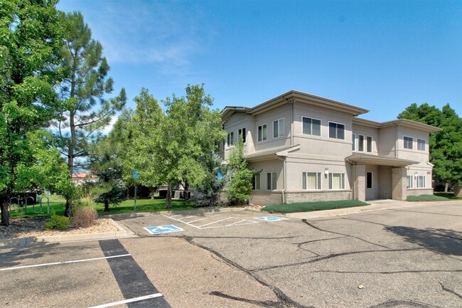
Property Detail
6620 Gunpark Dr
1463112-11-013
LOT 16 GUNBARREL SQUARE
Storesoffices
BOULDER
MF
Colorado
B and X Area of moderate flood hazard, usually the area between the limits of the 100-year and 500-year floods.
16
2024
0.66 AC
2025
Boulder
012707
Denver
9,044 SF
Boulder, CO
NEARBY LISTINGS FOR SALE OR LEASE
DEMOGRAPHICS near 6620 Gunpark Dr
1 mile
3 mile
5 mile
2025 Total Population
6,207
17,040
63,905
2030 Population
6,118
16,885
63,801
Pop Growth 2025-2030
(1.43%)
(0.91%)
(0.16%)
Average Age
42
44
42
2025 Total Households
3,136
7,393
27,628
HH Growth 2025-2030
(1.63%)
(1.10%)
(0.18%)
Median Household Inc
$103,640
$117,965
$106,164
Avg Household Size
2.00
2.20
2.20
2025 Avg HH Vehicles
2.00
2.00
2.00
Median Home Value
$798,414
$847,085
$925,341
Median Year Built
1984
1982
1983
Nearby Places
Map Layers
Map Styles
 Street
 Aerial
Layers
 Traffic
 Biking
Places
Listings with unknown addresses are not visible on the map
- Restaurants
- Banks
- Shops
- Fitness
- Groceries
PUBLIC TRANSPORTATION
AIRPORT
Denver International
Drive
Walk
Distance
Denver International
55 min
44.0 mi
SALE & LEASE HISTORY
LISTING DATE
SALE/LEASE

Sep 19, 2022
For Sale
Oct 27, 2021
For Sale
Nov 09, 2021
For Lease
May 11, 2023
For Lease
Jan 26, 2021
For Lease
Nearby Properties
Address
Land Use
TOTAL SIZE
Lot Size
Zoning
Address
Land Use
TOTAL SIZE
Lot Size
Zoning
17.51 AC
Address
Land Use
TOTAL SIZE
Lot Size
Zoning
155.96 AC
Address
Land Use
TOTAL SIZE
Lot Size
Zoning
141.82 AC
A
Address
Land Use
TOTAL SIZE
Lot Size
Zoning
2,696,002 SF
344.44 AC
Address
Land Use
TOTAL SIZE
Lot Size
Zoning
97.48 AC
A
Address
Land Use
TOTAL SIZE
Lot Size
Zoning
558,472 SF
23.18 AC
Address
Land Use
TOTAL SIZE
Lot Size
Zoning
228.08 AC
A
Address
Land Use
TOTAL SIZE
Lot Size
Zoning
158.31 AC
Address
Land Use
TOTAL SIZE
Lot Size
Zoning
38.79 AC
RR
Address
Land Use
TOTAL SIZE
Lot Size
Zoning
147.13 AC
A
Address
Land Use
TOTAL SIZE
Lot Size
Zoning
48.98 AC
A
Address
Land Use
TOTAL SIZE
Lot Size
Zoning
161.08 AC
A
Address
Land Use
TOTAL SIZE
Lot Size
Zoning
158.19 AC
A
Address
Land Use
TOTAL SIZE
Lot Size
Zoning
159.19 AC
A
Address
Land Use
TOTAL SIZE
Lot Size
Zoning
42.88 AC
RR
Address
Land Use
TOTAL SIZE
Lot Size
Zoning
161,711 SF
20.40 AC
MH
Address
Land Use
TOTAL SIZE
Lot Size
Zoning
107.31 AC
A
Address
Land Use
TOTAL SIZE
Lot Size
Zoning
27.92 AC
RR
Address
Land Use
TOTAL SIZE
Lot Size
Zoning
223,669 SF
14.27 AC
Address
Land Use
TOTAL SIZE
Lot Size
Zoning
304,116 SF
23.66 AC
MF
Address
Land Use
TOTAL SIZE
Lot Size
Zoning
165.77 AC
A
Address
Land Use
TOTAL SIZE
Lot Size
Zoning
86.70 AC
A
Address
Land Use
TOTAL SIZE
Lot Size
Zoning
267.15 AC
RR
Address
Land Use
TOTAL SIZE
Lot Size
Zoning
33.28 AC
A
Address
Land Use
TOTAL SIZE
Lot Size
Zoning
150.10 AC
A
Address
Land Use
TOTAL SIZE
Lot Size
Zoning
1,072,030 SF
119.89 AC
Address
Land Use
TOTAL SIZE
Lot Size
Zoning
84.07 AC
A
Address
Land Use
TOTAL SIZE
Lot Size
Zoning
80.83 AC
A
Address
Land Use
TOTAL SIZE
Lot Size
Zoning
79.23 AC
A
Address
Land Use
TOTAL SIZE
Lot Size
Zoning
118.35 AC
The World's #1 Commercial Real Estate Marketplace
Connect with us
© 2026 CoStar Group
The information above has been obtained from sources believed reliable. While we do not doubt its accuracy we have not verified it and make no guarantee, warranty or representation about it. It is your responsibility to independently confirm its accuracy and completeness. Any projections, opinions, assumptions, or estimates used are for example only and do not represent the current or future performance of the property. The value of this transaction to you depends on tax and other factors which should be evaluated by your tax, financial, and legal advisors. You and your advisors should conduct a careful, independent investigation of the property to determine to your satisfaction the suitability of the property for your needs.